Boat Instruments
$6.99
2.52for iPhone, iPad and more
Age Rating
Boat Instruments Screenshots
About Boat Instruments
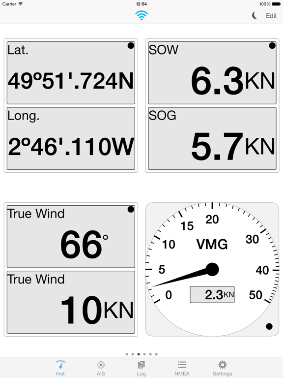
AIS, GPS and instruments for your boat. Essential and useful companion to boat instrumentation or to complement the GPS functions of your device. The app connects through Wifi to NMEA bridges that transmit instrumentation and AIS data. You can configure flexible pages of analog and digital instruments, which display realistic gauges and panels:
● Depth, speed, course, wind, location, rudder, rpm. More instruments in future versions.
The AIS screen shows relative position, speed and course for nearby targets that the on board AIS receiver is reporting. A minimum safe distance can be used to show warnings about potential collisions. The relative direction of travel of targets is shown in colours to indicate relative position in 5, 10 and 20 minutes.
● Relative course and speed, collision detection, forecast position.
ABOUT US
Imray is the leading publisher of nautical charts, books and apps. Our charts, designed and published in England for nearly 200 years, feature popular, carefully edited and award-winning cartography.
Look out for other applications in the Marine Navigation Series from Imray
Follow us on Twitter @imray_charts
Facebook @imraynautical
LANGUAGES
English, Dutch, French, German, Italian, Spanish, Japanese
Show More
What's New in the Latest Version 2.52
Last updated on Nov 17, 2020
Old Versions
New November 2020 - bug fix for shortened NMEA sentences
Show More
Version History
2.52
Nov 17, 2020
New November 2020 - bug fix for shortened NMEA sentences
2.5
Oct 7, 2019
• iOS13 compatibility including dark mode.
2.43
Aug 1, 2018
Option to set GPS source (NMEA or iPad/iPhone). In Preferences, for iPad/iPhone GPS, set GPS>On and Pref>GPS. For NMEA, set GPS>On and Pref>NMEA
2.42
Feb 13, 2018
Updated app compatibility
2.41
Apr 19, 2017
Updated app compatibility
2.40
Oct 10, 2016
NEW:
• iOS10 compatibility
2.30
Nov 21, 2014
AIS Target list
2.20
Jul 19, 2014
NEW:
• Polar instrument for true wind
• AIS distance rings display
2.10
• Speed instruments for lower speed sailing boats (0-20)
• Polar instrument for apparent wind
• AIS: order targets by closest distance
• AIS: settings to show or hide components
• AIS: option to show the course of a ship as true or relative
• AIS: auto-update of ship information
• Tide calculation using the best heading available (true, magnetic, COG)
• Wind calculation using the best heading available (true, magnetic, COG).
2.10
Jul 17, 2014
NEW:
• Speed instruments for lower speed sailing boats (0-20)
• Polar instrument for apparent wind
• AIS: order targets by closest distance
• AIS: settings to show or hide components
• AIS: option to show the course of a ship as true or relative
• AIS: auto-update of ship information
• Tide calculation using the best heading available (true, magnetic, COG)
• Wind calculation using the best heading available (true, magnetic, COG).
2.00
Apr 26, 2014
• New user interface for iOS7
• AIS target colour identifiers for different types of ship
• Support for magnetic wind to north direction when true value is not received from NMEA
• AIS target colour identifiers for different types of ship
• Support for magnetic wind to north direction when true value is not received from NMEA
1.80
Oct 21, 2013
NEW:
• Velocity Made Good instrument
• AIS target information now expands
• iOS7 enable AIS & NMEA in charts application
• Velocity Made Good instrument
• AIS target information now expands
• iOS7 enable AIS & NMEA in charts application
1.70
Sep 12, 2013
NEW:
• iOS compatibility
• AIS view retina compatibility
• iOS compatibility
• AIS view retina compatibility
1.60
Jul 10, 2013
NEW:
• North up / course up for AIS
• Simrad AIS compatibility
• AIS base stations
• Enhanced night / day visibility
• Support for NMEA Pressure, Air Temperature, Voltage, Current
• Calculated true wind
• North up / course up for AIS
• Simrad AIS compatibility
• AIS base stations
• Enhanced night / day visibility
• Support for NMEA Pressure, Air Temperature, Voltage, Current
• Calculated true wind
1.50
May 24, 2013
NEW:
• Farenheit sea temperature instrument
• Additional NMEA sources
• Auto update target display list
• Stability improvements
• Farenheit sea temperature instrument
• Additional NMEA sources
• Auto update target display list
• Stability improvements
1.40
May 7, 2013
NEW:
• Analog, digital, history, composite instruments grouping
• Auto-reconnect on connection or data timeout
• Settings on/off
• Performance improvements
• Analog, digital, history, composite instruments grouping
• Auto-reconnect on connection or data timeout
• Settings on/off
• Performance improvements
1.30
Apr 18, 2013
NEW:
• Additional AIS information about vessels (destination, eta, gps device)
• Improvements to target viewing (individual and group)
• Combine device GPS and data from AIS receiver
• Export targets
• Improvement to heading, when not available from certain AIS messages
• Additional AIS information about vessels (destination, eta, gps device)
• Improvements to target viewing (individual and group)
• Combine device GPS and data from AIS receiver
• Export targets
• Improvement to heading, when not available from certain AIS messages
1.2
Apr 3, 2013
NEW:
• UDP connection
1.1
• Composite gauge showing true and apparent wind on the same gauge
• Graphical gauges for depth, SOW, SOG and true wind speed showing changes over time
• Show AIS on top of charts (requires Marine Imray Charts app)
• AIS simulation uses realistic data
• Support for new NMEA sentences
• Display now shows indicator for number of pages
• Improved usability when adding and removing gauges
• Depth changes added to simulation
1.1
Mar 26, 2013
NEW:
• Composite gauge showing true and apparent wind on the same gauge
• Graphical gauges for depth, SOW, SOG and true wind speed showing changes over time
• Show AIS on top of charts (requires Marine Imray Charts app)
• AIS simulation uses realistic data
• Support for new NMEA sentences
• Display now shows indicator for number of pages
• Improved usability when adding and removing gauges
• Depth changes added to simulation
UDP in Version 1.2
1.0
Jan 30, 2013
Boat Instruments FAQ
Click here to learn how to download Boat Instruments in restricted country or region.
Check the following list to see the minimum requirements of Boat Instruments.
iPhone
Requires iOS 8.0 or later.
iPad
Requires iPadOS 8.0 or later.
iPod touch
Requires iOS 8.0 or later.
Boat Instruments supports English, Dutch, French, German, Italian, Japanese, Spanish