Apps in this category do not contain restricted content.
9+
Apps in this category may contain mild or occasional cartoon, fantasy or real-life violence, as well as occasional or mild adult, sexually suggestive or horrifying content and may not be suitable for children under 9 years of age.
12+
Apps in this category may contain occasional mild indecent language, frequent or intense cartoon or real-life violence, minor or occasional adult or sexually suggestive material, and simulated gambling, and may be for children under 12 years of age.
17+
You must be at least 17 years old to access this App.
Apps in this category may contain frequent and intense offensive language; Frequent and intense cartoon, fantasy or realistic violence: frequent and intense adult, scary and sexually suggestive subjects: as well as sexual content, nudity, tobacco, alcohol and drugs, may not be suitable for children under 17 years of age.
NYC Maps – Subway, Bus, & LIRR Capturas de tela
About NYC Maps – Subway, Bus, & LIRR
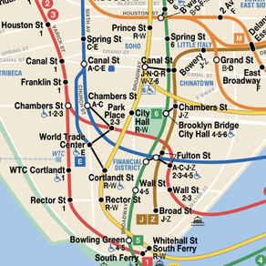
A simple New York City (NYC) subway map, along with bus maps for the Bronx, Manhattan, Brooklyn, Queens, and Staten Island, and a map of the LIRR. Zoom in as far as you'd like, the map stays crisp and clear.