- Share a GeoPDF file with the app to import it and use it as a custom map
- Filter nearby peaks by isolation
- Indicate whether peaks have saved maps when viewing list of peaks
- Update offline peak databases
- Save common filter settings as presets
- Topographic maps for British Columbia, Serbia, Bosnia and Herzegovina, Montenegro, Montserrat, Dominica, British Virgin Islands, Saint Helena
- Individual settings for units of temperature and wind speed
- Update 2023 fire layer
- Update offline peak databases
- Includes all peaks in the Database of British and Irish Hills
- Links to peaks on hikr.org, mostly in Europe
- Topographic maps for Peru
- Update 2023 fire layer
- Update offline peak databases
- Fix the smoke layer
- Fix background track recording on iOS 16.4+
- Topographic maps for Britain, Dominican Republic, Faroe Islands, Greenland, Haiti, Italy, Kosovo, Montenegro, Namibia, Portugal, Puerto Rico, US Virgin Islands, French overseas areas
- Show range for peaks (on More page); click to see all peaks in range
- Add 2023 fire layer
- Update offline peak databases
- Topographic maps for Ecuador, Slovenia, Taiwan, South Africa, Guatemala, Nicaragua, El Salvador, Costa Rica, Panama, and much of Nepal
- Measure distance between two points on the map
- Highlight buddies on leaderboards
- Leaderboards for prominence thresholds (access via Statistics)
- Links to some European peaks on hribi.net
- Update offline peak databases
- New photo viewer mode with pinch-to-zoom and swipe right/left
- Show ascents without peaks (created via the Web site)
- Update offline peak databases
- Update 2022 fire layer
- Italian language translation
- Waypoint icons
- Map layer showing areas saved offline
- Improved behavior with large fonts
- Update offline peak databases
- Update 2022 fire layer
- Polish language translation
- Show frequent climbing buddies on ascent stats page
- Offer to translate trip reports to your device's language
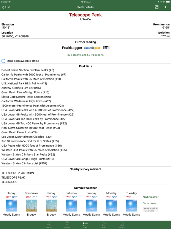
- Show weather forecasts for non-US peaks
- Option to retry failed downloads (in failure notification)
- Menu option to sort folders at the bottom of the saved tracks list
- Update offline peak databases
- Update 2022 fire layer
Fehlerbehebungen und neue Funktionen
- Topo maps for Germany, Sweden, Norway, Finland, Iceland
- Option to disable drawing all tracks on the map
- Option to reset nearby peak filter settings
- Share a peak to other apps
- Select ascent's start elevation from the map
- Search by coordinates handles more formats
- Bug fixes
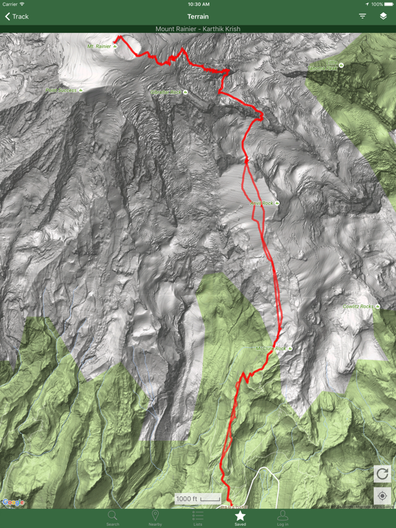
- 3D satellite mode
- Download up to 10 tracks for a peak at once ("Download tracks" from menu)
- Historical fire layer showing all years at once
- Get stats for a subsection of an elevation profile by holding down two fingers
- Create a peak list from nearby peaks ("Create new list" from menu)
- Topo maps for Switzerland, Belgium and Queensland
- Update offline peak databases
- Show prominence on climbed peaks on the map
- See what peaks on a list one of your buddies has climbed ("View as buddy" from menu when viewing a list)
- Filter option to see all nearby peaks above a prominence threshold, or peaks on a list, at the same time
- Sort list of peak lists by distance to you
- Indicate which peaks are saved when looking at a list
- German, Russian, Lithuanian translations
- Update offline peak databases
- Add 2021 fire layer
- Snap drawn tracks to trails or roads
- Show first ascents, solo ascents, route/gear tables on ascent stats page
- Share peak lists with others (via menu on list details page)
- Search on buddies page
- Small bug fixes and interface improvements
- Snap drawn tracks to trails or roads
- Show first ascents, solo ascents, route/gear tables on ascent stats page
- Share peak lists with others (via menu on list details page)
- Search on buddies page
- Small bug fixes and interface improvements
- Edit and simplify tracks (via menu on track details page)
- Global slope angle map layer
- Searching for climbers matches both first and last names
- Setting to override dark mode
- Snow cover layer on map
- Make location dot into a directional arrow
- Import FIT files (from Garmin, Strava, etc.)
- Filter nearby peaks to those with tracks
- Add "electric bike" to ascent machine options
- Update offline peak databases
- Show links to Summits on the Air and the Database of British and Irish Hills on the peak details page, including when offline
- High temperature, wind speed, and precipitation layers for the U.S.
- Show photos of benchmarks when available (bottom of datasheet page)
- Show peak names in phone's language where available
- Peaks with less than 300 feet (or 100m) of prominence are shown with smaller red dots on the map
- Interactive track trimming mode (from menu), in case you forget to stop recording a track when you drive away
- Reworked map tile selection menu
- Update 2020 fire layer
- Menu option to go from track to ascent it came from (newly added tracks only)
- Interactive track smoothing mode
- Improved fire and smoke layers
- Historical fires back to the year 2000
- Bug fixes and small adjustments
- Read all trip reports for a peak on one page
- Menu option to smooth a jittery GPS track
- Share a URL to an ascent
- Update offline peak database
- Update 2020 fire layer
- Bug fixes
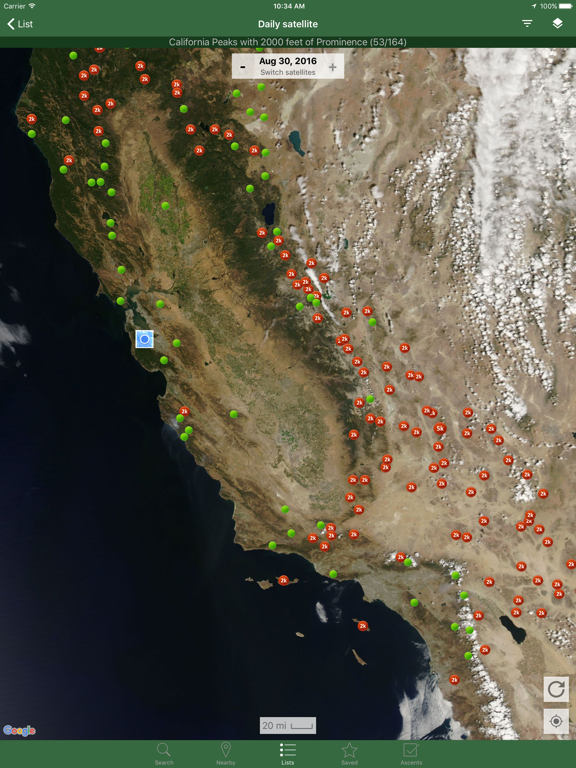
- New weekly satellite imagery
- Topo maps for South Australia
- Bulk delete in track waypoint and route pages
- Show phase of the moon and hours of daylight
- Protected land layer can be saved offline
- Topo maps in Mexico can be saved offline
- Click on key saddle on peak's "More" page to see it on a map
- Click on "+N more" ascents on a peak to see all of your ascents of the peak when you have more than 5
- Update offline peak databases
- Spanish translation
- Fix some layout and large font bugs
- Filter nearby peaks to minimum and maximum elevation
- Get weather anywhere (long press on the map, U.S. only)
- Show moonrise and moonset on peak details page
- Put timestamps on waypoints
- Dark mode
- Option to ignore a peak list (in menu when viewing a list)
- Improve look and behavior of search box on list pages on iOS 11+
- Update offline peak databases
- Update 2019 fire layer
- Fixes for iOS 13
- Animated weather radar
- Graph of routes and gear used for a peak under "More"
- Allow much larger tracks to be loaded without simplification, up to 75k points
- New mode that shows lists of a composite track's waypoints and routes ("Waypoints & routes" from menu when viewing a track that has waypoints or sub-routes)
- Option to sort a climber's personal peak lists on top in Lists
- Update offline peak database
- Update global topo layer: cover all northern latitudes, newer OpenStreetMap data, fix holes in contour lines
- Add 2019 fire layer
- Many small bug fixes
- Set personal priority on anyone's personal list to add it to your lists
- Leaderboards for prominence index (P-Index) and other indices in menu
- ListsOfJohn.com members can see nearby ListsOfJohn peaks while offline
- Personal lists can be deleted, and peaks can be bulk removed from personal lists
- On statistics page, select prominence threshold for per-day calendar display
- 3D Touch on app icon for shortcuts
- Fix track recording stopping after a long period of being stationary