FingerMap

FingerMap


Calculate distance and surface


$0.99

2.1.0for iPad
Gilthonwe Apps
Developer
47.6 MB
Size
Jun 28, 2022
Update Date
Utilities
Category
4+
Age Rating
Age Rating
4+
Apps in this category do not contain restricted content.
9+
Apps in this category may contain mild or occasional cartoon, fantasy or real-life violence, as well as occasional or mild adult, sexually suggestive or horrifying content and may not be suitable for children under 9 years of age.
12+
Apps in this category may contain occasional mild indecent language, frequent or intense cartoon or real-life violence, minor or occasional adult or sexually suggestive material, and simulated gambling, and may be for children under 12 years of age.
17+
You must be at least 17 years old to access this App.
Apps in this category may contain frequent and intense offensive language; Frequent and intense cartoon, fantasy or realistic violence: frequent and intense adult, scary and sexually suggestive subjects: as well as sexual content, nudity, tobacco, alcohol and drugs, may not be suitable for children under 17 years of age.
FingerMap Screenshots
FingerMap posterFingerMap posterFingerMap posterFingerMap posterFingerMap poster

About FingerMap

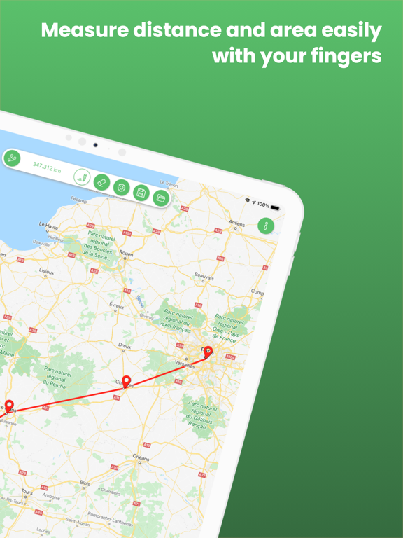
Whether you want to calculate the distance between two or more locations or the area of any places (e.g. stadium, park, lake, mountain, city, etc.), FingerMap is the perfect tool for you!

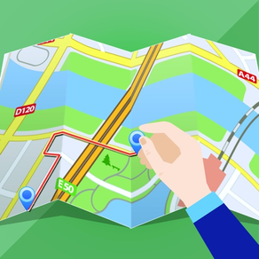
To draw a path on the map is really easy. Simply hold on your finger on the map until a pin appears where your finger is, then just move your finger on the map. Once you release your raise your finger, the drawing is done.
If you want to draw lines, simple hold on your finger on various locations of the map until they are reunited with a line.
You can switch from distance to area move and vice versa. The drawing on the map will be automatically updated.

When you are ok with your drawing, simply save it with a name to use it later. All saved drawings can be exported to GPX or KML file and shared with your contacts. You can even see the image generated by the path without the need of an internet connection.

You can customize the drawing by choosing any color you want.

Various types of map to choose from:
- Apple (standard / satellite / hybrid)
- HikeBikes
- Nokia OVI Maps (normal / satellite / terrain)
- OpenCycleMap (normal and transport)
- OpenStreetMap

With a swipe of a finger on the measure, you can easily change the unit used. Based on the measure, the system will automatically take the most appropriate unit.

For distance:
- meter / kilometer
- yard / mile
- rod / chain
- fathom / nautical mile

For area:
- square meter / square kilometer
- square yard / square mile
- are / hectare
- rood / acre

More exciting features to come in the future…

If you have any questions or feedback, please don’t hesitate to contact us via the feedback form in the app or by sending us an email at support@gilthonwe.com
Show More

What's New in the Latest Version 2.1.0

Last updated on Jun 28, 2022
Old Versions
Bugfixes and improvements
Show More
Version History
2.1.0
Jun 28, 2022
Bugfixes and improvements
2.0.0
Dec 12, 2020
We have completely rebuilt the app from scratch.
We updated the layout to make it clearer and more simple.
Lots of improvements and bugfixes under the hood!
1.2.1
Jul 17, 2017
Bugfixes
1.2
Aug 1, 2016
- Removed support for MapQuest map tiles
- Added compatibility with iPad Pro
- Added portrait mode
- Added support for multitasking / split view
- Fixed a bug when saving path
- Dropped support for iOS7
1.1.2
May 3, 2015
Bugfix
1.1.1
Nov 3, 2014
Bugfixes
1.1
Oct 4, 2014
Bugfixes for iOS8
1.0
Aug 24, 2014

FingerMap FAQ

Click here to learn how to download FingerMap in restricted country or region.
Check the following list to see the minimum requirements of FingerMap.
iPad
Requires iPadOS 12.0 or later.
FingerMap supports English, French

FingerMap Alternative

You May Also Like

Get more from Gilthonwe Apps