* Added Map Token Support for editing maps shared by a map token.* Added Support for Multi Profiles & Accounts (login to multiple accounts at the same night, without needing to logout)* New Map Groups on the Main Menu organized by recently opened, incident near me, map types and more.* Optional Read-only/Locked mode for shared maps to prevent accidental edits to shared maps.
* Base layer screen can now be accessed from the main menu sidebar.
* New download region screen for downloading base layers as local tile caches
* New release notes screen for viewing recent changes to the app. This now appears on new installs and can also be accessed from the main menu sidebar
* Added torch to QR Code scanner* Bug Fixes including important fix for iOS 12 devices crashes during startup.* Bug fix for NSW Traffic Cameras layer*
- bug fixes
- added terms and conditions
- better error messages for location permission issues
Feature Toolbar Changes - added semi-transparent background to the toolbar to make the toolbar easier to see on top of the map. The background changes based on if the user is using the toolbar, selecting a feature, opens a feature editor or moves the map around. The toolbar goes transparent with the user is using the map and opaque when the user is using the toolbar in order to make the most of the available screen space.
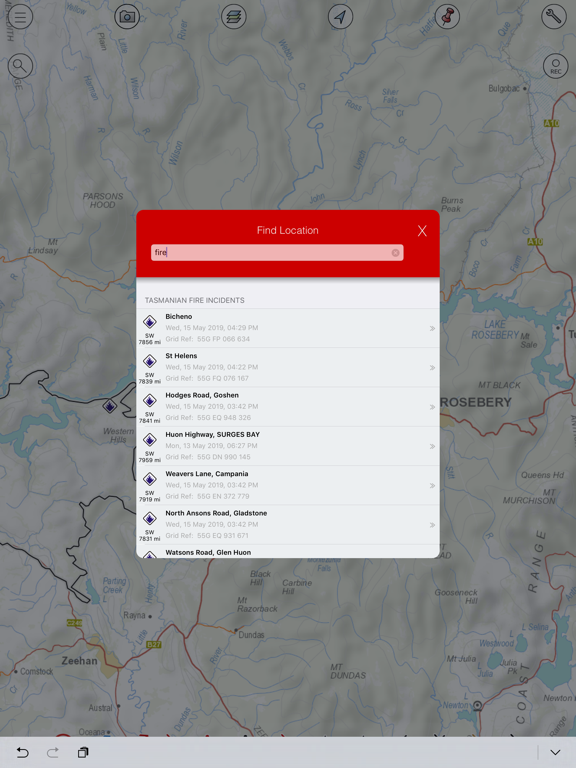
Feature Type Search - added a search screen for searching for feature types. You can search for multiple key words such as “Red Label”, which will break up the search to first filter by the value “Red” and then filter the result set again by “Label”, to only show results that match on “Red” and “Label”. Any type selected on the symbology screen is added to the recent section of the toolbar. There is a maximum of 5 of the most recent items in the recent section. If you select a item on the toolbar directly (via one of the favorite groups, it does NOT get added to the recent types list)
Rotation Popup View - added a popup that appears when adding a point type that supports a rotation. This popup is designed to make it much easier to add rotated points to the map.
Fixed KML Export - removed deleted features from export.
Layer Brightness Support - added layer brightness support to the toolbar, so the toolbar background is black when the layer brightness is turned down and white background when the layer brightness is turned up. Also added support for the point/lines/area/label editors for layer brightness support.
High Resolution Photo support
Bug Fixes
-> feature size slider for changing the size of features on the map-> layer brightness slider for changing the layer brightness on the map-> bug fixes
Bug fix for iPhone 11 & iPhone 14.
-> Updated main menu layout
-> Added ability to search maps from the main menu
-> New smart QR code scanner for scanning QR codes for GeoPDFs, KML, KMZ, GPX files. Can also be used to scan FireMapper Licence QR codes.
-> added support for WA DBCA GeoPDFs-> added support for viewing PDF attachments on shared maps-> added status to shared map list so its easier to see if there are connection issues on the main menu (e.g. no internet connection)
-> added dropbox menu on the main menu in the top right corner for quick access to user profile, symbology and documentation.-> updated the popup view for selected features (6 figure grid ref is now displayed in bold, time interval is since last change is displayed in the top corner of the popup)
- fixed CSV export bug- address field is now auto-populated when adding point features to the map (if you are zoomed in on the map when adding a point)- new layer sidebar (for changing base layers, turning on/off overlays, turning on/off feature layers, show/hide feature types)- new camera tool and photo overlay (new camera view for iPads)- improvements for location sharing- adding support for searching for tracks.- improved support for NZTM- improved Send Map As Email (deleted features removed)
* support for importing geopdfs generated by FireWatch Pro/Landgate website.
* support for importing geospatial pdfs generated by ArcGIS Pro (with PDF compression). This allows users to import GeoPDFs that are commonly used by NIFC/Cal Fire.
* An error message is now displayed if an imported pdf has a map projection that is not supported by FireMapper.
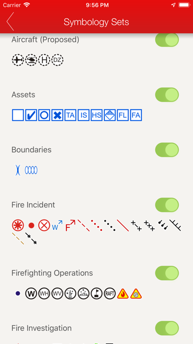
* Added new USA ICS symbols (NWCG Standard Geospatial Operations). This includes all the new USA symbology for 2022.
* Updated PDF manual in the iOS app. This manual is included in the app so it is available offline (with no internet connection).
* Added a link on the main menu of the app to the new FireMapper Support Hub (docs.firemapper.app) for downloading manuals, user guides and more.
* Improved performance when switching between different base layers, especially over slower internet connections.* Fixes for Quebec Romer Grid Searches* Added support for easting/northing searches
-> Added Search and Rescue symbols
-> Added Photos to CSV export
- SK Retardant Calculator- Fixes to line and area editors
-> added a fit to extents that moves the map view to the shared features on the map-> fix for line feature layer
-> Added support for drawing areas-> UI Improvements
fixed bug with photo upload
-> Updated line editor
-> Added the ability to edit existing lines
bug fix for editing map name/notes on map properties screen
Navigate to the selected feature with Foreflight & OzRunways
-> Added Foreflight + OZ Runways Integration-> Fixes for KML/GPX export.
-> New Download Feature dialog