V12.3.3
- Resolved additional Glympse issues
- iOS 17 compatibility improvements
- Fixed an issue that caused Glympse to not work correctly on iPads (v12.3.2)
--------
V12.3.0 - 12.3.1
-------
- Added Support for Hot Air Pyrometers!
- updates for iOS 14
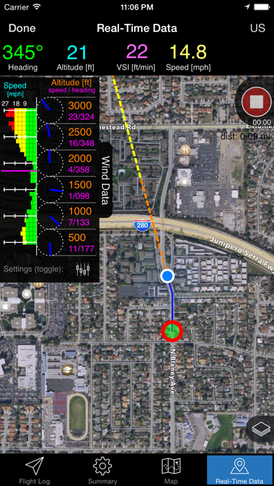
- Updates to the real-time display - added extra bar to better clearly display flight time and Pyrometer temperature. Extra bar needed to remain compatible with devices with small screens.
- Facebook SDK updated to 14.1.0. (from 9.3.0)
- Changed the 4th default weather service to: https://ltaweather.com/ (from Weather underground)
- Other small bug fixes
- Version 12.3.1 specifically fixed a small potential crash when performing an intermediate save of a track in the background while recording a flight.
v12.3.0:
- Added Support for Hot Air Pyrometers!
- updates for iOS 14
- Updates to the real-time display - added extra bar to better clearly display flight time and Pyrometer temperature. Extra bar needed to remain compatible with devices with small screens.
- Facebook SDK updated
- Other small bug fixes
--------
New In Version 12.2.0
-------
- Added Apple Watch Extension
- iOS 15 compatibility updates
- A few minor bug fixes
- Limited Glympse invite expirations to +4 hours. This is a due to a Glympse library limitation. If times were selected that were longer than 4 hours it resulted in an error.
- Fixed crashes related to devices whose default language is French
- Glympse: Added option to set a custom avatar (icon)
- Glympse: Fixed crash when sending invite on some devices
- Glympse: Properly stopped sending position updates when closing real-time tab
- Backup/Export: slight update to the interface
- Wind Data Plot: Improved visibility of wind direction line
- Wind Data Plot: swapped wind speed and heading (now reads heading / speed)
- iPad support for split screen
- Reduced iOS requirement to iOS 12.3+
- Version 12.0.1 - addresses some crashes on app launch
- Glympse: Fully revamped integration
- Glympse Tags (hashtags): Can be used to track multiple balloons at once! (Great when flying with others or at Festivals)
- Measure tool: new highly requested feature
- Offline maps: revamped to work with latest Mapbox API. Fully updated map imagery (clear cache and re-download for potential new imagery in your area)
- Offline maps: auto downloader potential crash fixed
- KML overlays: Added the ability to open/import KML or KMZ files directly from local Files or iCloud storage
- KML overlays: Added option to share (export) an overlay (swipe left on overlay item)
- KML overlays: Fixed potentially erroneous import error messages
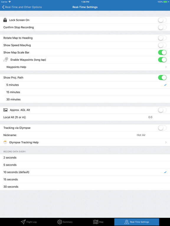
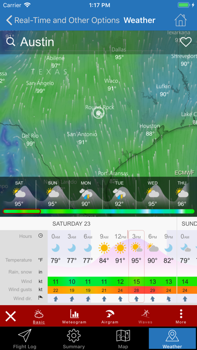
- Weather: Customize up to four different weather sites to use from within the app
- AGL Altitude (approx.): Added option to ask what ground elevation reference to use for displaying altitude between the saved value set in the settings, the current GPS value, or to revert to MSL.
- AGL Altitude (approx.): fixed a bug where wind data was always in MSL even if the AGL setting was turned on (now if the altitude display is AGL so is the wind data).
- Map Tab: Added option to customize the date range to show flights on the map (and a label that shows the flight count).
- Sharing all Flight Tracks ("New/Export Flight Tracks" on Real-time tab [as KML]) now uses the standard Apple share dialog instead of being limited to just e-mail
- iOS 14 compatibility updates (extensive) [app now requires iOS 13.0+]
- Updated to latest Facebook SDK (v9.1.0)
- New Icon
- Glympse: Fully revamped integration
- Glympse Tags (hashtags): Can be used to track multiple balloons at once! (Great when flying with others or at Festivals)
- Measure tool: new highly requested feature
- Offline maps: revamped to work with latest Mapbox API. Fully updated map imagery (clear cache and re-download for potential new imagery in your area)
- Offline maps: auto downloader potential crash fixed
- KML overlays: Added the ability to open/import KML or KMZ files directly from local Files or iCloud storage
- KML overlays: Added option to share (export) an overlay (swipe left on overlay item)
- KML overlays: Fixed potentially erroneous import error messages
- Weather: Customize up to four different weather sites to use from within the app
- AGL Altitude (approx.): Added option to ask what ground elevation reference to use for displaying altitude between the saved value set in the settings, the current GPS value, or to revert to MSL.
- AGL Altitude (approx.): fixed a bug where wind data was always in MSL even if the AGL setting was turned on (now if the altitude display is AGL so is the wind data).
- Map Tab: Added option to customize the date range to show flights on the map (and a label that shows the flight count).
- Sharing all Flight Tracks ("New/Export Flight Tracks" on Real-time tab [as KML]) now uses the standard Apple share dialog instead of being limited to just e-mail
- iOS 14 compatibility updates (extensive) [app now requires iOS 13.0+]
- Updated to latest Facebook SDK (v9.1.0)
- New Icon
Version 11.0.1: Fixed issue when restoring a backup.
-----------
New In Version 11.0
-----------
- Added waypoints! See the Waypoints help section under real-time settings for details on how to use the feature.
- Added a summary of crew flight frequency (all time, 30, 90, 180, and 365 days) to the Summary Tab. This data is sortable by crew member name or by flight count.
- KMZ files are now supported for overlays! (The KMZ files are expanded and converted to KML by the Hot Air app). KML is still preferred but many KMZ files should now work.
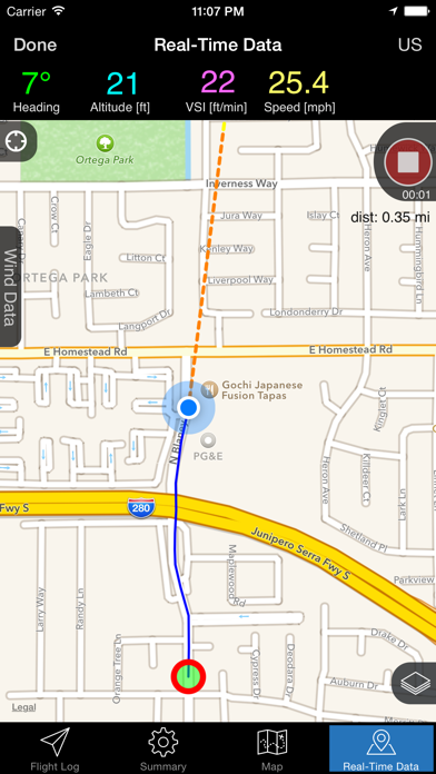
- Changed the real-time wind speed/direction chart to now increment by 100 ft (100 m) instead of 500 ft (200 m) so it can be more finely tuned.
- Flight track images can now be shared to any app (not just e-mail) including being saved to the photo library
- Significant improvements to all flight track sharing options
- Added 3D touch shortcuts to quickly open Real-Time Flight Tracking and the Payload Calculator
- The "Real-Time Flight Tracking" menu item now stands out more (the cell is taller and the icon larger and red).
- Updated interface graphics (e.g., solid blue title bars which makes buttons and titles easier to read, etc.)
- Added additional sharing options in Backup data for "export all flight data" as sometimes these files may get too large to send via e-mail
- Added haptic feedback (small vibration) when real-time recording is started and stopped.
- Compass on real-time map now appears in the lower left corner of the map when needed (iOS 11+)
- Fixed passengers count limit (the app was not saving values over 100)
- App rating request system updated to make it easier to rate app and hopefully less annoying (thanks for taking the time to do this it really helps!)
- Updated Facebook SDK to 4.33.0 (for sharing to Facebook)
- Many other small bug fixes and improvements (iOS 11.4 compatibility, etc.)
- Thanks to everyone who has sent me suggestions. If your ideas didn't make it into this version I either wasn't able to come up with a good way to add it yet or ran out of time. However, they are all still on my idea list and will be considered for future updates.
-----------
New In Version 11.0
-----------
- Added waypoints! See the Waypoints help section under real-time settings for details on how to use the feature.
- Added a summary of crew flight frequency (all time, 30, 90, 180, and 365 days) to the Summary Tab. This data is sortable by crew member name or by flight count.
- KMZ files are now supported for overlays! (The KMZ files are expanded and converted to KML by the Hot Air app). KML is still preferred but many KMZ files should now work.
- Changed the real-time wind speed/direction chart to now increment by 100 ft (100 m) instead of 500 ft (200 m) so it can be more finely tuned.
- Flight track images can now be shared to any app (not just e-mail) including being saved to the photo library
- Significant improvements to all flight track sharing options
- Added 3D touch shortcuts to quickly open Real-Time Flight Tracking and the Payload Calculator
- The "Real-Time Flight Tracking" menu item now stands out more (the cell is taller and the icon larger and red).
- Updated interface graphics (e.g., solid blue title bars which makes buttons and titles easier to read, etc.)
- Added additional sharing options in Backup data for "export all flight data" as sometimes these files may get too large to send via e-mail
- Added haptic feedback (small vibration) when real-time recording is started and stopped.
- Compass on real-time map now appears in the lower left corner of the map when needed (iOS 11+)
- Fixed passengers count limit (the app was not saving values over 100)
- App rating request system updated to make it easier to rate app and hopefully less annoying (thanks for taking the time to do this it really helps!)
- Updated Facebook SDK to 4.33.0 (for sharing to Facebook)
- Many other small bug fixes and improvements (iOS 11.4 compatibility, etc.)
- Thanks to everyone who has sent me suggestions. If your ideas didn't make it into this version I either wasn't able to come up with a good way to add it yet or ran out of time. However, they are all still on my idea list and will be considered for future updates.
Version 10.1.1: Fixed issue with sharing a ground track to Facebook on iOS 11.
------------------
Version 10.1 Updates:
-------------------
iOS 11 compatibility updates including:
- fixed issue for KML overlay pins not showing text when selected
- fixed issue of KML overlay selection not saving between sessions
- iPhone X Compatibility
- fixed flight track trim button, so it isn't so close to the edge to help the control work better
- facebook posting iOS 11
- Export/import a single flight track from one device to another (available in the share options of the Flight Track Details view)
- Export flight tracks as .GPX (GPS Exchange Format)
- Display a map scale option (default this is turned on)
- Option to get a confirmation dialog when ending a flight recording to prevent accidentally stopping a recording. (default this is off)
- Added more KML sharing options for Flight Track export (e.g., iMessage, Airdrop, etc.); now it isn't as specific to sharing with just the Google Earth app.
- Fixed Glympse crashes when loading contacts information (in iOS 10+)
- iOS 10 compatibility updates
- Fixed the issue with sharing ground tracks to Facebook where only a link to Hot Air would appear and not the flight track image (this was due to a change by Facebook)
- The flight track line is now thicker when sharing an image via Facebook or e-mail
- Fixed a couple of small bugs
V9.1.3
-----------
- Improved the real-time tracking to lessen the chance that the track will "snap" to roads.
V9.1.2
-----------
- Fixed issue dealing with Offline In-App Purchases (Apple recently changed how to verify the results)
- Optimization improvements
- Updated icon for the larger iPad Pro
New in Version 9.1:
-----------------------
- Added a payload calculator!
- Added the ability to view weather within the app (via https://www.windyty.com)
- iOS 9 compatibility updates
- Enabled split screen on capable iOS 9 iPads
- Now requires iOS 8.0+
New in version 9.0
-------------------------
- Offline Maps Major New Feature: Auto map downloader. This makes it much easier to download maps for a specific area for offline use
- iPhone 6, and 6+ native resolution support!
- Super high-resolution graphics for retina HD compatible devices
- Flatter cleaner graphics (e.g., record/stop buttons, flight log list, tab bar)
- When recording a flight track the time-elapsed is displayed below the button to make it easier to read.
- GPS warning now includes directions for Settings/Privacy/Enable Location Services which sometimes gets disabled when updating iOS versions.
- Other small bug fixes and iOS 8 compatibility issues
Bug fixes for the iPad:
- e-mail bar and text were both white, now the bar is blue
- corrected issue where on some devices the e-mail composer wouldn't display when trying to send KML files
New in Version 9.1:
-----------------------
- Added a payload calculator!
- Added the ability to view weather within the app (via https://www.windyty.com)
- iOS 9 compatibility updates
- Enabled split screen on capable iOS 9 iPads
- Now requires iOS 8.0+
New in version 9.0
-------------------------
- Offline Maps Major New Feature: Auto map downloader. This makes it much easier to download maps for a specific area for offline use
- iPhone 6, and 6+ native resolution support!
- Super high-resolution graphics for retina HD compatible devices
- Flatter cleaner graphics (e.g., record/stop buttons, flight log list, tab bar)
- When recording a flight track the time-elapsed is displayed below the button to make it easier to read.
- GPS warning now includes directions for Settings/Privacy/Enable Location Services which sometimes gets disabled when updating iOS versions.
- Other small bug fixes and iOS 8 compatibility issues
Note: I had planned on including a lot of other features in this update (thanks to all who have sent me their ideas). Some are taking me a little longer to implement. So instead of holding back all of the finished features I decided to release this version now. Some of the big items I am working on are adding customizable waypoints, a lift calculator, and better data export options.
- a few iOS 8 compatibility fixes
- Glympse stability improvements
(Cooler stuff coming later)
- Fixed a bug that could, under certain cases, cause too much data to be trimmed from a flight track.
- Fixed drag and drop bug
- Glympse update - now it plays nicely with status bar on iOS 7
v8.0.2
------
- Fixed Glympse!
- Now you can e-mail a single KML file that contains all the 3D flight paths of all saved flight tracks.
- Added splash screens
v8.0
------
This a big update and marks the 4th year Hot Air has been on the App Store! (This also marks the 34th free update) Thanks for all the support!
- iOS 7 optimizations and redesign
- Offline maps! This allows the map data to be cached locally and used when you have poor connectivity or to save data. (This option is available through a reasonably priced yearly subscription to help cover the map data and server fees.)
- Offline maps include two styles: terrain map and hybrid satellite imagery
- Trim saved flight tracks! Next time you forget to stop recording a flight, you can easily trim off the extra data from within the app! This also lets you visualize the flight path over time.
- Significantly better Facebook sharing. Including posting a map with your full flight track that is color coded for altitude.
- Major performance increase in rendering KML overlays.
- Real-time map rotation (2-finger gesture) and 3D perspective.
- Automated cleanup of any iCloud data corruption issues (this should clear some cases that would cause the app to crash when saving data).
- Many other smaller updates and bug fixes.