The online tourist guide of Hungary, specially developed for hikers, bikers, trailrunners, rockclimbers and water sports lovers, featuring a built-in tour planner, as well as hundreds of recommended tours and thousands of sights, all with detailed descriptions and plenty of photographs, comfortably viewable on an interactive map. Available for free, with a subscription option for extended functionality.
Features
• Various interactive, zoomable, vectorized, worldwide hiking maps with all the marked trails, showing your current position
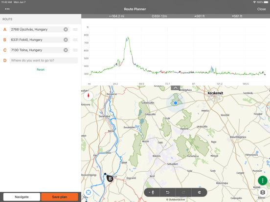
• A convenient way to plan your own tour on the map, and get length, duration and elevation profile immediately
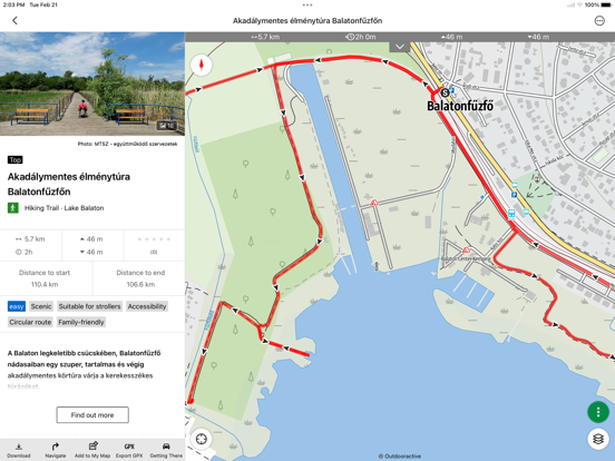
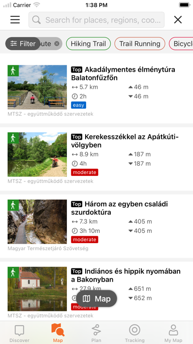
• More than a thousand recommended tours for hikers, bikers, trail runners and canoers, with practical data, detailed description of the best sights nearby, natural and cultural background, good quality photographs and information on how to get there
• Thousands of recommended sights in Hungary, including lookout towers, natural panorama points, forest trains, fortresses and museums, with detailed description, good quality photographs, plus information on how to get there
• Hundreds of accomodations, including huts, tourist hotels and apartments, near marked trails
• Useful collections with map view: beaches around lake Balaton, ice-skating arenas, botenical gardens, the best trail-running routes, rock-climbing places, tours for people living with disabilities etc.
• Notices, warnings and closures
• Download map sections, tours and sights for offline use
• On-the-fly navigation along the route with a live elevation profile and voice instructions
• Record your route
• BuddyBeacon: share your positon with friends live
• The complete Hungarian Blue Tour, with official sections and route, POIs and accomodations
• Synchronise all your content between computer and mobile devices running the app
• Check the local weather forecast
• 3D-flight: a virtual bird’s eye view of the tour
• Useful tools built in, such as peak finder (Skyline) and compass with your current position
• Community services: rate and share contents with your friends
Exclusively for Pro members
Go anywhere : Outdooractive Pro works offline without mobile and data signals. Unlimited lists can also be created and the app is ad-free. In addition, you are able to view satellite imagery, the unique Outdooractive map with over 30 activity trail networks and official topographic maps.
Exclusively for Pro+ members
Pro+ also contains official maps from Alpine Associations as well as premium maps from KOMPASS.
Apple Watch:
Record a track or follow a route on your phone and see it on your watch. Pan and zoom maps.
Apple Health:
Record a track or follow a route on your phone and see it on your watch. Pan and zoom maps.When you record a cycling, hiking, walking or running track you are able to save work outs to Apple Health. Data from HealthKit will not be used for marketing or promotional purposes.
Your iTunes account will be charged to the amount of the subscription fee after your purchase has been confirmed and after the trial period has expired. The subscription renews annually unless the automatic renewal is deactivated at least 24 hours before the end of the current billing cycle or during the trial period. Costs for any unused periods of the term will not be reimbursed. The option to deactivate can be found in your iTunes account settings. Your account will be charged for the renewal amount within the 24-hour period before the end of the current billing cycle. www.outdooractive.com/en/terms-and-conditions.html
If you have questions or suggestions, please visit https://www.termeszetjaro.hu/hu/p/gyakran-ismetelt-kerdesek/41050512/
Our desktop version:
https://www.termeszetjaro.hu/
Follow us on Facebook:
https://www.facebook.com/Termeszetjaro.hu/
Contact us:
termeszetjaro@termeszetjaro.hu
More about the TEKA card:
http://www.termeszetjarokartya.hu/