Visitor Map

Visitor Map


Map of Forest Service lands


무료

1.2.8for iPhone, iPad and more
5.1
53 Ratings
US Forest Service
Developer
225.4MB
Size
Dec 13, 2023
Update Date
Travel
Category
4+
Age Rating
Age Rating
4+
Apps in this category do not contain restricted content.
9+
Apps in this category may contain mild or occasional cartoon, fantasy or real-life violence, as well as occasional or mild adult, sexually suggestive or horrifying content and may not be suitable for children under 9 years of age.
12+
Apps in this category may contain occasional mild indecent language, frequent or intense cartoon or real-life violence, minor or occasional adult or sexually suggestive material, and simulated gambling, and may be for children under 12 years of age.
17+
You must be at least 17 years old to access this App.
Apps in this category may contain frequent and intense offensive language; Frequent and intense cartoon, fantasy or realistic violence: frequent and intense adult, scary and sexually suggestive subjects: as well as sexual content, nudity, tobacco, alcohol and drugs, may not be suitable for children under 17 years of age.
Visitor Map 스크린 샷
Visitor Map 포스터Visitor Map 포스터Visitor Map 포스터Visitor Map 포스터Visitor Map 포스터Visitor Map 포스터Visitor Map 포스터Visitor Map 포스터

About Visitor Map

Explore the great outdoors by visiting America’s backyard -- 193 million acres of national forests and grasslands. Find your perfect spot on these expansive lands that include more than 4,300 campgrounds and 158,000 miles of trails, including 31,900 miles on pristine wilderness areas.

Discover our rich cultural heritage at such destinations as Chimney Rock National Monument. Step back into time by stepping on tracks left 150 million years ago by dinosaurs at the Picket Wire Trail in southeast Colorado, where you also can see Native American rock art, ruins from the Dolores Mission and Cemetery and the old Rourke cattle ranch.

These lands also play host to more than 6,000 miles of wild and scenic rivers that offer leisurely rides passed awe-inspiring scenery or breathtaking rollercoaster-like rides down rapids. We are your year-round destination, including skiing on one of the 122 ski areas in the winter, photographing the bursting colors of wildflowers, cooking s’mores around the campfire in the summer or watching leaves change colors in the fall.

Notable app. features include:
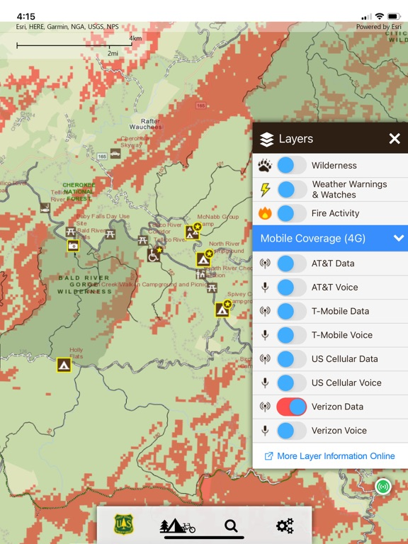
* accessible recreation locations
* simplified and streamlined map interface
* national-level search capabilities
* wildfire and weather warnings/watches
* easily share the map through email or on social networks
Show More

최신 버전 1.2.8의 새로운 기능

Last updated on Dec 13, 2023
오래된 버전
Fixes broken links.
Show More
Version History
1.2.8
Dec 13, 2023
Fixes broken links.
1.2.6
Oct 6, 2022
• Enabled multiple activity selection. Ability added to allow multiple activities to be selected at one time. Ability to favorite a recreation site and include notes
• Added the ability to favorite recreation opportunity sites and add notes.
• Added major mobile provider 4G data and voice coverage area layers (online only)
• Added sorting (ascending and descending) by date or forest name to offline maps list.
• Temporarily disabled feedback feature.
• Updated weather service to new NOAA service (resolves issue with weather layer loading).
• Updated base map services to new hybrid Esri Arcgis.com services.
• Added loader when toggling on- and offline
• Implemented support for app config changes between app releases (auto-download of updated configs)
• Updated domain url references to fs.usda.gov
• Miscellaneous bug fixes
• Miscellaneous styling updates
1.2.3
May 5, 2021
- "Force Offline" - ability added to force application to use offline maps. Useful for saving bandwidth and in locations with spotty connectivity.
- Increased height of main navigation to better support iPhone 11+
- Fonts updated
- Error reporting refined
- Fixed "my location" bug
- Fixed bug in RSS feed for fire data that prevented all data from displaying on map.
- Reworked map print to still include rasterized forest layers
1.2.2
Sep 9, 2020
* Critical patch for activity selection and map identification
- Misc. bug fixes
- Forest/Wilderness extent fix
- Informative popup added to initial offline basemap download
- Release notes linked on tools menu
1.2.1
Jul 14, 2020
Minimum iOS version set to 11
Basemap switched to tiled imagery for improved performance
Reported bug zooming in and out from clustered activities
1.2.0
Apr 24, 2020
• "Offline" mode – provides brand new capabilities without an internet connection.
- Providing nearly 100% app functionality while offline.
- Ability to download all forest data to local storage and view with a national basemap.
• Various stability enhancements.
1.1.0
Feb 3, 2020
- “Locate Me” feature and enhanced user interaction reporting and crash information.
- Enhanced analytics (Firebase integration)
- Updated map service references.
- Various bug fixes.
1.0.0
Jun 4, 2019

Visitor Map FAQ

제한된 국가 또는 지역에서 Visitor Map를 다운로드하는 방법을 알아보려면 여기를 클릭하십시오.
Visitor Map의 최소 요구 사항을 보려면 다음 목록을 확인하십시오.
iPhone
iOS 14.4 이상 필요.
iPad
iPadOS 14.4 이상 필요.
iPod touch
iOS 14.4 이상 필요.

Visitor Map 대안

당신은 또한 좋아할 수도 있습니다

US Forest Service에서 더 많은 것을 얻기