MapMyPlaces

MapMyPlaces


Multi-stop routing made easy.


FreeOffers In-App Purchases

2.9.8for iPhone, iPad and more
5.7
15 Ratings
John Kearon
Developer
6.2 MB
Size
Mar 20, 2023
Update Date
Navigation
Category
4+
Age Rating
Age Rating
4+
Apps in this category do not contain restricted content.
9+
Apps in this category may contain mild or occasional cartoon, fantasy or real-life violence, as well as occasional or mild adult, sexually suggestive or horrifying content and may not be suitable for children under 9 years of age.
12+
Apps in this category may contain occasional mild indecent language, frequent or intense cartoon or real-life violence, minor or occasional adult or sexually suggestive material, and simulated gambling, and may be for children under 12 years of age.
17+
You must be at least 17 years old to access this App.
Apps in this category may contain frequent and intense offensive language; Frequent and intense cartoon, fantasy or realistic violence: frequent and intense adult, scary and sexually suggestive subjects: as well as sexual content, nudity, tobacco, alcohol and drugs, may not be suitable for children under 17 years of age.
MapMyPlaces Screenshots
MapMyPlaces posterMapMyPlaces posterMapMyPlaces posterMapMyPlaces posterMapMyPlaces posterMapMyPlaces poster

About MapMyPlaces

MapMyPlaces is a great tool for generating directions from multiple locations, not just 2 locations.

Use this app to plan or record a multi-step tour or journey.

Add a location by simply touching the map, entering a search term in the search bar, selecting a location from your contacts or by selecting a photo from your photo albums.

IFeatures:

▪ Add any number of locations on a map.
▪ Add locations by touching the map, entering an address or search term in the Search Bar, by selecting a contact or by selecting a photo from your photo albums.
▪ Locations added from photo albums will automatically have their addresses looked up and displayed.
▪ Create and view a slideshow of photos you select from your camera roll.

Optional Features:

Save Data, Plot Photos & Email (Optional)

▪ Preserves your privacy by storing your data on your device, not on a website, you have to log into to use. (Data is stored on your device not in iCloud, so try to backup your device periodically).
▪ Create a group of locations once, then save them so that you don’t have to recreate them again the future.
▪ Plot locations and create a route using any photo with geolocation data on your device or in iCloud.
▪ Create a slideshow from any photo on your device (by double tapping the photo attached to a location), while also displaying the photo’s location on a map..
▪ For locations you will use repeatedly, save it as a favorite. The addresses of these photos will be automatically generated.
▪ Location address information can be added to your Contacts Address book.
▪ The order of locations can be modified or reversed.
▪ Import and Export location and route data in GPX and KML format..
▪ Emailed groups have a image of your route, a text description of your route, and both GPX and KML attachments that can be loaded onto GPS devices and various websites.
▪ Sync routes among your devices and the devices of your friends and associates by emailing the route to them.
▪ An unlimited number of routes can be saved and viewed even when your device is not connected to the internet.

Routing (Optional)

▪ Create walking, cycling or driving routes of up to 26 locations while connected to the internet.
▪ Create point-to-point routes with an unlimited number of locations even when your device is not connected to the internet.
▪ Preserves your privacy by storing your data on your device, not on a website you have to log into to use.
▪ Both visual and written directions with distance and time estimates are created for a route.
▪ Distances are measured in miles or kilometers.
▪ The distance to a pin location from your current location can be displayed.
▪ A scale of miles/kilometers is displayed at the top of your map.
Show More

What's New in the Latest Version 2.9.8

Last updated on Mar 20, 2023
Old Versions
On the main menu, replaced Email a route with Export a Route. Upon selecting the Export Route menu option, the user will be presented with a choice of three methods of exporting a route to another app or device.

Email format will generate an email consisting of a print out of all the locations in the route, as well as a TXT attachment which can be used to import the route into this app on other devices.

GPX format consists of the Latitude and Longitude (GPS) data of the route, which can be exported to apps that can read GPX data on this device or other devices.

KML format consists of the Latitude and Longitude (GPS) data of the route, which can be exported to apps that can read KML data on this device or other devices.
Show More
Version History
2.9.8
Mar 20, 2023
On the main menu, replaced Email a route with Export a Route. Upon selecting the Export Route menu option, the user will be presented with a choice of three methods of exporting a route to another app or device.

Email format will generate an email consisting of a print out of all the locations in the route, as well as a TXT attachment which can be used to import the route into this app on other devices.

GPX format consists of the Latitude and Longitude (GPS) data of the route, which can be exported to apps that can read GPX data on this device or other devices.

KML format consists of the Latitude and Longitude (GPS) data of the route, which can be exported to apps that can read KML data on this device or other devices.
2.9.7
Nov 12, 2022
Fixed issues that prevented MapQuest and Apple directions from working properly.
2.9.6
Nov 30, 2021
Minor bug fixes.
2.9.5
May 19, 2021
Fixed issues involving importing KML files into the app.
2.9.4
Jul 30, 2020
Added display of your compass heading in degrees, latitude, longitude and altitude when viewing your devices heading.

To center your map on your current position, tap on the current location icon located in the bottom left corner of your map. Tapping on the current location button a second time, displays your heading, where the map rotates in the direction you are holding your device. When you do that, the compass degrees are now displayed, along with your latitude, longitude and altitude. Tapping the current location button a third time, turns off your heading display. To return the map to showing north at the tap of your device, tap on the Compass button located in the top right hand corner of your map.
2.9.3
May 20, 2020
Various minor bug fixes.
2.9.2
Oct 9, 2019
Restored the background color of pins to the original green color.
Corrected the display of the panorama images displayed in your photo albums.
2.9.1
Oct 2, 2019
Added support for iOS 13 Dark Mode.

Added support for the “mmp” file type to enable emailing your route data between your devices.
2.9
Jun 13, 2019
Improved the search feature.
2.8.9
Apr 30, 2019
Added a prompt for the user's permission to access the device's Photo Library when attempting to create a screenshot using the "Save Route Image" main menu option. This prompt will only appear if the user had not previously given the app permission to access the device's Photo Library.

For suggestions or questions about how to use this App please contact the developer via email using the FAQ option on the Main Menu. Using the FAQ email option provides the developer with the ability to have a conversation with the user concerning any issues with this App.
2.8.8
Dec 19, 2018
Expanded the display of pin location detail information to fully fill the screen on the iPhone X series of phones.
Added the display of a pin location's title when viewing a slide show of photos in your route.

Anyone with questions or suggestions about this app can contact the developer via the FAQ option on the app's main menu.
2.8.7
Nov 21, 2018
Refined the display of map area photo moments to display only those photos that are located in the map area displayed on your device.

Previously, if a single photo was located within the map area photo moment, all the photos within that moment would be displayed including photos located outside the map area of your device.

A photo moment is all the photos you took on a single day. You may have taken photos over a large area and only wish to plot those photos in one part of this large area. Now you can limit the photos to be plotted to only those photos contained in the map area displayed on your device.
2.8.6
Aug 31, 2018
Fixed an issue with Apple generated directions that was causing the app to crash.
2.8.5
Apr 28, 2018
1) Added the option of displaying a 3D map
2) Added the option of copying the location of a pin to your clipboard so that you can paste it into another app.
2.8.4
Dec 15, 2017
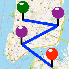
As requested, added the display of the distance between locations alongside the previous display of cumulative distance for locations in your route.
2.8.3
Nov 4, 2017
Enlarged the thumbnail images of photos in your photo albums and route locations.

This should make it much easier to select the photos that you want to use to create a route. It will also make it much easier to view the thumbnail images of any route locations that have an photos.
2.8.2
Oct 7, 2017
Added the option to limit the display of Photo Moments to those Moments that have photos taken in the current map area displayed on your device.

Just tap on the Map Area button at the top of the Photo Moments Listing screen to reduce the display of moments to the current map area displayed on your device.

This feature will make it easier to create routes in your current map area, from your device or iCloud photos, without having to remember when you originally took those photos.
2.8.1
Jul 29, 2017
1) Minor bug fixes in anticipation of the future release of iOS 11.
2) Added video preview to App Store.
2.8
Jul 14, 2017
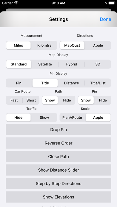
1) Added support for the display of traffic conditions on your map.

2) Added the option of displaying Apple or PlanARoute scale of distance on your map.
2.7
Jun 23, 2017
Added the ability to share your current location via your device's clipboard.
2.6.1
Apr 23, 2017
Minor number formatting bug fixes.
2.6
Mar 28, 2017
Minor bug fixes
2.5
Jan 6, 2017
MapMyPlaces is now a "Universal" app, which means it works the same way on your iPad and iPhone.

iPad users will now be able to use MapMyPlaces in a "Slide Over" or "Split View" window on their iPad.

With this feature iPad users can use MapMyPlaces simultaneously along with another app.
2.4.3
Dec 3, 2016
1) Fixed a bug when attempting to "Save As" when merging a group into your current group. You now can choose to save the merged group into your current group, or save the combined group into a new group.
2) Fixed occasional crashes that may have occurred when buying optional features from the app store
2.4.2
Oct 22, 2016
Hopefully, fixed the bug of the "Loading Spinning Wheel" doesn't disappear when downloading the app for the first time from the App Store.

MapMyPlaces FAQ

Click here to learn how to download MapMyPlaces in restricted country or region.
Check the following list to see the minimum requirements of MapMyPlaces.
iPhone
Requires iOS 12.0 or later.
iPad
Requires iPadOS 12.0 or later.
iPod touch
Requires iOS 12.0 or later.
MapMyPlaces supports English, French, German, Spanish, Traditional Chinese
MapMyPlaces contains in-app purchases. Please check the pricing plan as below:
Routing
$1.99
Save Data, Plot Photos & Email
$1.99

Related Videos

Latest introduction video of MapMyPlaces on iPhone

MapMyPlaces Alternative

You May Also Like

Get more from John Kearon