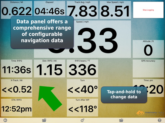
Main-screen data boxes enhanced (tap-and-hold at edge of screen)
Display GPS range-rings (GPS Settings)
New Odometer data item (tap-and-hold to reset, pause or rename)
Access overlays list from main screen toolbar
Improved many dialog layouts
Tap a track to select/edit
Find time, speed and altitude at any point on a track
Split/Join tracks (tap on track)
Split/Join routes (Waypoint Operations)
Track-to-Route and Route-to-Track conversion
New Live Data item: Goto / Show % Along Route
New Context menu for Live Data Goto and Track Items
New Live Data items: Instruments / True Wind Range and True Wind Gust.
View Map list by Folder
Info button to show total size of maps in a folder
Delete a set of maps by folder
Added "Other -> Load Layout" button for switching between Nav data layouts
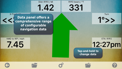
Added new "Instrument" Nav data items
Bug fixes
Bug fixes
"Coming up" waypoint list in Nav Data screen
Timer & Start Line in Nav Data
Configurable "Drop Mark" button in Nav Data
Access the GPS Lock and Unlock button for iPhone X
Much faster map downloads
Map list uses Expanding view instead of Map Types button
Layout works with iPhone X, XR, XS
Network works with system proxy setup
2.0.2: Fix for default background location activity mode.
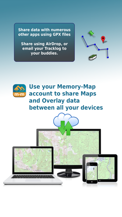
2.0.0: Major update with many new features. Memory-Map is now available for Mac, too. Use your desktop for planning, then sync your routes to the iPhone or iPad for use on the go. Afterwards, sync again to review, analyze and archive your tracklogs.
+ On-screen map scale bar
+ Overlay settings to hide/show marks/routes/tracks
+ Bulk Download option to download the whole map
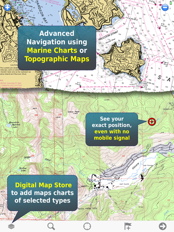
+ My Online Maps - shows a list of maps you have purchased in the Digital Map Store
+ Search Digital Map Store by keyword or place name
+ Interactively re-arrange live navigation data panel items
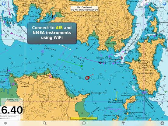
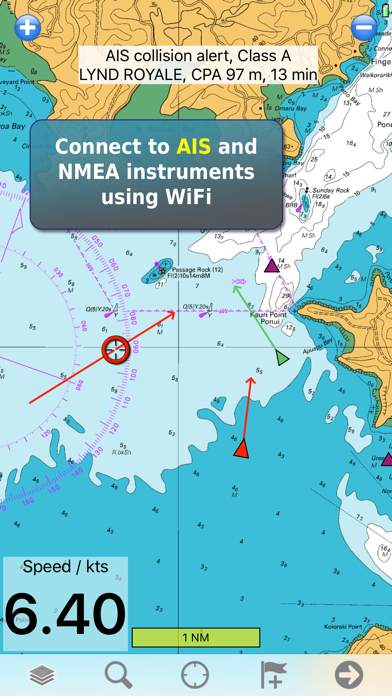
+ AIS, connect to marine instruments via WiFi (pro feature)
+ Proximity alarm, Anchor alarm (pro feature)
Please review the app if you like this update!
2.0.1: Fix for default background location activity mode.
2.0.0: Major update with many new features. Memory-Map is now available for Mac, too. Use your desktop for planning, then sync your routes to the iPhone or iPad for use on the go. Afterwards, sync again to review, analyze and archive your tracklogs.
+ On-screen map scale bar
+ Overlay settings to hide/show marks/routes/tracks
+ Bulk Download option to download the whole map
+ My Online Maps - shows a list of maps you have purchased in the Digital Map Store
+ Search Digital Map Store by keyword or place name
+ Interactively re-arrange live navigation data panel items
+ AIS, connect to marine instruments via WiFi (pro feature)
+ Proximity alarm, Anchor alarm (pro feature)
Please review the app if you like this update!
Major update with many new features. Memory-Map is now available for Mac, too. Use your desktop for planning, then sync your routes to the iPhone or iPad for use on the go. Afterwards, sync again to review, analyze and archive your tracklogs.
+ On-screen map scale bar
+ Overlay settings to hide/show marks/routes/tracks
+ Bulk Download option to download the whole map
+ My Online Maps - shows a list of maps you have purchased in the Digital Map Store
+ Search Digital Map Store by keyword or place name
+ Interactively re-arrange live navigation data panel items
+ AIS, connect to marine instruments via WiFi (pro feature)
+ Proximity alarm, Anchor alarm (pro feature)
Please review the app if you like this update!
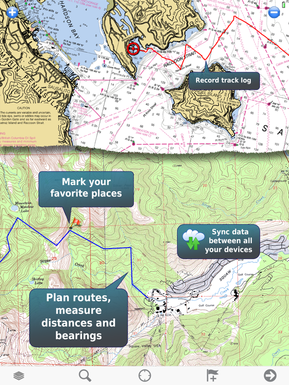
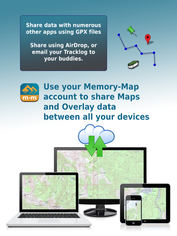
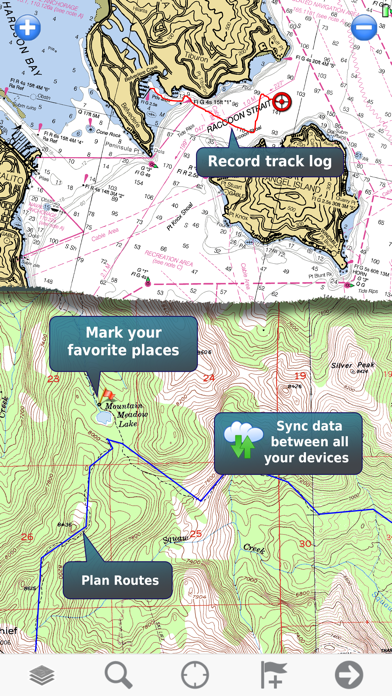
Cloud Sync your marks, routes and tracks between all your devices
Performance and stability improvements
"Cancel Navigation" to stop Go-To or Follow Route
Changed minimum iOS deployment target to iOS 8.1
No other changes.
iOS 7 users who recently updated and are having compatibility problems should now delete the app and reinstall from the app store. This should put you back to Memory-Map version 1.6.2.
Bug fix for iOS8
Map detail page shows update/revision info
NOTE: This update requires iOS 9.0 or later.
Fixed crash when viewing marks and waypoints imported from other apps
Fixed 3D touch problems
Fixed auto-rotation and multi-tasking layout problems
Fixed background GPS tracklog recording
IMPORTANT NOTE: There is a bug in this update that causes a crash if you are using marks or routes imported from other apps. Please contact Memory-Map if your app is crashing and we can help you work around the problem. A new update is coming soon.
New app icon
Fixed bug: Change Data on Main Screen
Fixed bug: iPad flip-side screen size
Fixed loss of map licenses after uninstall
Fixed sliders for track/route line width and opacity
Added support for map packages
Full set of mark icons from PC app
Better icon selector
Classic Maps is now an In-app purchase (Free for a limited time)
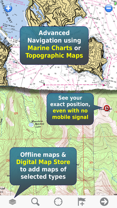
DeLorme Topo maps available in-app. Up-to-date topo maps with trails and public land boundaries.
Tap "More Maps" and "Digital Map Shop" to access a range of premium maps.
"Preview" maps before buying.
1.6.1: No changes from 1.6.0
1.6.0: Added support for iPhone 5.
Added in-app purchase of selected maps
iPhone 5, full screen mode
Add the ability to purchase selected maps and to import 3rd party maps with in-app purchase
Performance improvements for iPad3
Map List now shows online maps that are already in your account.
Online maps that have you have previously purchased and activated on this device, are now accessible for download via the Online Maps listing.
Fixed Compass, which did not work in some devices.
Added option to turn off velocity averaging. If you are using a 3G iphone, we recommend turning velocity averaging on. Newer devices work best with it off.
WARNING: if your iOS device storage is nearly full, do not update. The operating system will delete your downloaded maps if you install the update.
This app now only shows free online maps & charts, and permits you to load maps you already own from your PC. There is no opportunity to buy additional content through the app.
Fixed importing of GPX icons.
Fixed accented characters in index, etc.
Fixed saving of sort settings
Fixed iphone-sized data layout on ipad
Fixed: occasional crash
Fixed: occasional duplication of overlay data.
GPS position icon is larger & has user-selectable color
Marks & waypoints have choice of icons and color
Wifi upload removed
Register button removed
Map detail shows whether the map was Downloaded from DMS or loaded into the iTunes shared documents folder.
Sort map list by name, scale or distance
Sort overlay data by name, date or distance
A number of important bug fixes, and new features to help manage DMS maps. If you like this update, write a review!
Fixed: Distance to End wrong if you follow a route, then goto a different waypoint.
Fixed: on iPad, data overlays on main map screen show in the wrong position.
Location button enabled while location is not from GPS
Fixed: Edit Track: Send button missing in Landscape mode
Fixed: Crash importing GPX file with empty CDATA (findmespot) or content begining with "/"
Fixed: When maps are added by iTunes filesharing, they now automatically appear int the map list.
Added: Configurable data item: Waypoint name
Added: Reverse route.
Added: Button to download a strip of map covering a route (downloadable QC3 maps only).
Added: For DMS Selections maps: Bulk Download -> Download All. Downloads all activated areas.
Added: Visualize your downloaded and activated map chunks
Text data fields have a translucent background for better readability.
Fixed: Save overlay name before sending email
Fixed: Magnetic bearings measured a long distance from the current GPS location
Added: Goto Mark and Follow route (Mark edit menus)
Added: Configurable data fields on main screen and flip side.
Added: Lock waypoints / Marks to prevent accidentally moving them.
Added: Changing the color of the active track now also sets the color of the GPS velocity vector, and sets the default color for new tracks.
Added: Wikipedia search (shows articles about the location viewed on the map).
Fixed: Send GPX file, cancel out of the email -> crash
Faster map downloads.
Fixed: Change maps automatically when GPS locked-on.
Better tracking when device is switched off and on
Note, if you like this app, please give us a quick review in the app store. It really helps us a lot!
+ Hi-res screen support for iphone 4
+ Fixed bulk download bug (incorrect area after download is cancelled)
+ Fixed blank map screen after you Cancel the map list
+ Fixed opening URL/GPX while app is running in the background
+ Fixed unintentional GPS use when device is turned off.
Ported to iOS4
Support for File Sharing in iTunes
Support for running as background process
Fixed WiFi upload crash
Compass turned off when moving, to save power
Fixed sending individual marks, routes and tracks as GPX files
Tightened valid GPS accuracy threshold (again)