RealityMaps 3D tour planner

RealityMaps 3D tour planner


Ski, Hike, Bike, Mountaineer


FreeOffers In-App Purchases

1.9.230913for iPhone, iPad and more
9.7
19 Ratings
3D RealityMaps GmbH
Developer
463.2 MB
Size
Sep 14, 2023
Update Date
Navigation
Category
4+
Age Rating
Age Rating
4+
Apps in this category do not contain restricted content.
9+
Apps in this category may contain mild or occasional cartoon, fantasy or real-life violence, as well as occasional or mild adult, sexually suggestive or horrifying content and may not be suitable for children under 9 years of age.
12+
Apps in this category may contain occasional mild indecent language, frequent or intense cartoon or real-life violence, minor or occasional adult or sexually suggestive material, and simulated gambling, and may be for children under 12 years of age.
17+
You must be at least 17 years old to access this App.
Apps in this category may contain frequent and intense offensive language; Frequent and intense cartoon, fantasy or realistic violence: frequent and intense adult, scary and sexually suggestive subjects: as well as sexual content, nudity, tobacco, alcohol and drugs, may not be suitable for children under 17 years of age.
RealityMaps 3D tour planner Screenshots
RealityMaps 3D tour planner posterRealityMaps 3D tour planner posterRealityMaps 3D tour planner posterRealityMaps 3D tour planner posterRealityMaps 3D tour planner posterRealityMaps 3D tour planner posterRealityMaps 3D tour planner posterRealityMaps 3D tour planner poster

About RealityMaps 3D tour planner

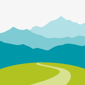
PHOTOREALISTIC 3D MAPS FOR BETTER TRIP PLANNING
The award-winning outdoor navigation app is the perfect tool for planning your next trip and finding your way around. The unique photo-realistic 3D representation of the mountain landscape allows an intuitive, realistic assessment of the terrain and the requirements. Many practical features help you to plan your next trip. These include GPS tracking, a routing function, GPX import into the 3D map and map download for offline use.


MAPS FOR SUMMER & WINTER
The 3D map summer is based on aerial photos with a resolution of 20 cm and a matchless terrain model with a resolution of 60 cm. For winter we provide a 3D relief map with all ski resorts and high-resolution aerial photos for selected regions.


QUALITY-CERTED TOURS
The app offers hiking, mountain, ski and bike tours exclusively researched by experts from Bergverlag Rother and other partners. For all tours there is an elevation profile, photos and directions. With the GPS function, you can easily follow the marked route while on tour. A highlight is the import of any tours in GPX format or from Komoot into the 3D map.


SIMPLE AND SAFE ORIENTATION ON THE MOVE
With the combination of 3D map, aerial photo and topographical relief map on a scale of 1:25,000, you can perfectly prepare yourself for a trip. With the routing function, you can plan new routes on the 3D map. The GPS tracking function turns your smartphone into a full-fledged navigation device. On tour, your current location is always displayed live on the map. A virtual 360° panorama with information about the surrounding landscape makes it easier for you to find your way around.


RECORD YOUR OWN TRACKS
With the tracking function, you can record your track and display the route covered live on the 3D map. Duration, distance, altitude and speed are continuously determined. With a user account, you can save the recorded tracks in your personal tour cloud, transfer your tracks to other smartphones or tablets and share them with friends.


MORE SAFETY IN THE MOUNTAINS - OFFLINE MAPS
The app offers an unprecedented level of security. In the photo-realistic 3D map you can read the exposure and condition of the terrain and identify danger spots. In bad weather, in fog or at night, you can find your way around as the map depicts the real terrain. Another safety aspect: you can load the maps onto your smartphone for offline use.


EXCLUSIVELY FOR PREMIUM USERS
With a PREMIUM subscription, you can record, save, share and transfer your tracks to other devices, save maps offline on your smartphone, import tours in GPX format and from Komoot, and plan tours in 3D. With the subscription we finance the further development of the app and the creation of the 3D maps. The subscription runs through the store and can be canceled at any time.


FREE TRIAL SUBSCRIPTION
With a test subscription you can use all PREMIUM functions for one week free of charge.


For more information visit https://www.realitymaps.app/realitymaps-app/


Terms and Conditions: https://www.realitymaps.app/agb/
Show More

What's New in the Latest Version 1.9.230913

Last updated on Sep 14, 2023
Old Versions
- Planning routes is now even easier
- Over 10,000 new tours
- Faster app launch
- Full integration of the new Tour Planner for the PC
- Plan with the Tour Planner for the PC directly on the 3D
Show More
Version History
1.9.230913
Sep 14, 2023
- Planning routes is now even easier
- Over 10,000 new tours
- Faster app launch
- Full integration of the new Tour Planner for the PC
- Plan with the Tour Planner for the PC directly on the 3D
1.9.230809
Aug 10, 2023
- Planning routes is now even easier
- Over 10,000 new tours
- Faster app launch
- Full integration of the new Tour Planner for the PC
- Plan with the Tour Planner for the PC directly on the 3D
1.9.230720
Jul 21, 2023
- Planning routes is now even easier
- Over 10,000 new tours
- Faster app launch
- Full integration of the new Tour Planner for the PC
- Plan with the Tour Planner for the PC directly on the 3D map
1.9.230714
Jul 15, 2023
10,000 new tours
Faster app launch
Improved handling when routing
Improvements to the tour cloud (faster saving and loading of own tours)
1.9.230712
Jul 13, 2023
Improved handling when routing
Several other improvements and bug fixes
1.9.230620
Jun 21, 2023
Improved loading time of the app
Further improvements and bug fixes
1.9.260525
May 26, 2023
Improved loading time of the app
Further improvements and bug fixes
1.9.230517
May 20, 2023
Several improvements and bug fixes.
1.9.221222
Dec 22, 2022
Discover the new regions "Julian Alps" and "Savinja Alps" as well as the new 3D winter map of the Pyrenees!
1.9.221216
Dec 16, 2022
We have completely revised the 'Plan tour' feature.
First select an activity and plan the tour on the topo map.
You can then display the tour on the 3D map.

You can now also
1.) set waypoints for intermediate destinations
2.) further edit an already planned and saved tour (move / delete waypoints)
3.) select the path condition that should be taken into account when routing
1.9.221215
Dec 15, 2022
We have completely revised the 'Plan tour' feature.
First select an activity and plan the tour on the topo map.
You can then display the tour on the 3D map.

You can now also
1.) set waypoints for intermediate destinations
2.) further edit an already planned and saved tour (move / delete waypoints)
3.) select the path condition that should be taken into account when routing
1.9.221012
Oct 13, 2022
We have completely revised the 'Plan tour' feature.
First select an activity and plan the tour on the topo map.
You can then display the tour on the 3D map.

You can now also
1.) set waypoints for intermediate destinations
2.) further edit an already planned and saved tour (move / delete waypoints)
3.) select the path condition that should be taken into account when routing
1.9.221007
Oct 7, 2022
We have completely revised the 'Plan tour' feature.
First select an activity and plan the tour on the topo map.
You can then display the tour on the 3D map.

You can now also
1.) set waypoints for intermediate destinations
2.) further edit an already planned and saved tour (move / delete waypoints)
3.) select the path condition that should be taken into account when routing
1.9.220909
Sep 10, 2022
Brand new 3D maps!
Discover the following new regions in addition to the existing 3D maps of the Alps:
- Himalaya with the highlight Mount Everest and Khumbu
- Ladakh
- Balearic Islands
- Canary Islands
- Corsica
- Pyrenees
1.9.220819
Aug 23, 2022
Brand new 3D maps!
Discover the following new regions in addition to the existing 3D maps of the Alps:
- Himalaya with the highlight Mount Everest and Khumbu
- Ladakh
- Balearic Islands
- Canary Islands
- Corsica
- Pyrenees
1.9.220805
Aug 5, 2022
Brand new 3D maps!
Discover the following new regions in addition to the existing 3D maps of the Alps:
- Himalaya with the highlight Mount Everest and Khumbu
- Ladakh
- Balearic Islands
- Canary Islands
- Corsica
- Pyrenees
1.9.220708
Jul 8, 2022
Brand new 3D maps!
Discover the following new regions in addition to the existing 3D maps of the Alps:
- Himalaya with the highlight Mount Everest and Khumbu
- Ladakh
- Balearic Islands
- Canary Islands
- Corsica
- Pyrenees
1.9.220701
Jul 1, 2022
Brand new 3D maps!
Discover the following new regions in addition to the existing 3D maps of the Alps:
- Himalaya with the highlight Mount Everest and Khumbu
- Ladakh
- Balearic Islands
- Canary Islands
- Corsica
- Pyrenees
3,777
1.9.220617
Jun 17, 2022
Brand new 3D maps!
Discover the following new regions in addition to the existing 3D maps of the Alps:
- Himalaya with the highlight Mount Everest and Khumbu
- Ladakh
- Balearic Islands
- Canary Islands
- Corsica
- Pyrenees
1.9.220609
Jun 9, 2022
Brand new 3D maps!
Discover the following new regions in addition to the existing 3D maps of the Alps:
- Himalaya with the highlight Mount Everest and Khumbu
- Ladakh
- Balearic Islands
- Canary Islands
- Corsica
- Pyrenees
1.9.220520
May 20, 2022
Brand new 3D maps!
Discover the following new regions in addition to the existing 3D maps of the Alps:
- Himalaya with the highlight Mount Everest and Khumbu
- Ladakh
- Balearic Islands
- Canary Islands
- Corsica
- Pyrenees
1.9.220513
May 16, 2022
Brand new 3D maps!
Discover the following new regions in addition to the existing 3D maps of the Alps:
- Himalaya with the highlight Mount Everest and Khumbu
- Ladakh
- Canary Islands
- Corsica
- Pyrenees
1.9.220414
Apr 14, 2022
Brand new 3D maps!
You can now also discover Mount Everest and the Canaries in 3D, in addition to the existing 3D map of the Alps.
1.9.220318
Mar 19, 2022
Updated 3D winter map
General improvements
1.9.220303
Mar 4, 2022
Updated 3D winter map
General improvements

RealityMaps 3D tour planner FAQ

Click here to learn how to download RealityMaps 3D tour planner in restricted country or region.
Check the following list to see the minimum requirements of RealityMaps 3D tour planner.
iPhone
Requires iOS 12.0 or later.
iPad
Requires iPadOS 12.0 or later.
iPod touch
Requires iOS 12.0 or later.
RealityMaps 3D tour planner supports English, German
RealityMaps 3D tour planner contains in-app purchases. Please check the pricing plan as below:
Premium (7 days)
$4.49
Premium (1 month)
$9.49
Premium (1 year)
$37.99

RealityMaps 3D tour planner Alternative

You May Also Like

Get more from 3D RealityMaps GmbH