What’s new in Wärtsilä iSailor
In this latest release, we are introducing a new annual subscription service. This means that all newly purchased chart folios will include a free correction service available to you all year round.
Whenever you choose your next sailing destination and purchase the chart folio through the Chart Store, you will see the subscription end-date for your correction service under the folio name.
Each time when a chart update is available, you will see a star notification and an update button in the Chart Store.
Your subscription will automatically renew unless auto-renewal is turned off at least 24 hours before the end of the subscription period. You can cancel your subscription in the Chart Store any time.
All previously purchased chart folios will remain available for you and can be restored from the service via the Chart Restore function. To receive subsequent chart corrections for your purchased charts, you will need to subscribe to the annual updates in the Chart Store.
NOTE: App Store will charge payment after confirmation of the chart correction purchase. You may manage your subscriptions and turn off the auto-renewal service in the Account Settings. If you re-subscribe, your new subscription will be automatically updated at the current price unless you cancel chart update service before the subscription period ends in Settings -> iTunes & App Store -> Apple ID -> View Apple ID -> Account -> Subscriptions.
We hope you enjoy this update and improved version of iSailor!
Happy sailing!
What’s new in the Transas iSailor 1.10.1:
• Bug Fixing, General Performance and Improvements
Sincerely yours,
Transas iSailor team
What’s new in the Transas iSailor 1.10.0:
• New GDPR EULA
• New ‘Navigational Danger’ alarm
• NMEA Trace logger for the technical support
• Improvements for Import & Export of the user data
• Advanced track export into GPX/KML/KMZ format
• Bug Fixing, General Performance and Improvements
Sincerely yours,
Transas Pilot team
• Bug fix for the AIS target name presentation
Sincerely Yours,
Transas iSailor team
• Bug fixing for sensors TCP connectivity
Sincerely Yours,
Transas iSailor team
What's new in the Transas iSailor version 1.9.1:
• New 'NavData from AIS Class A' in-app purchase option
Receive dynamic navigational data from AIS Class A (IMO type) transponders via TCP or UDP connection. When connected to the ECDIS or Pilot Plug port of the AIS Class A transponder, you can receive the following data:
- Positioning data
- Course-Over-Ground (COG)
- Speed-Over-Ground (SOG)
- Heading (HDG) and Rate-Of-Turn (ROT) data, if provided
Note: this option can only be purchased if the 'AIS Receiver Support' feature has been enabled before in iSailor
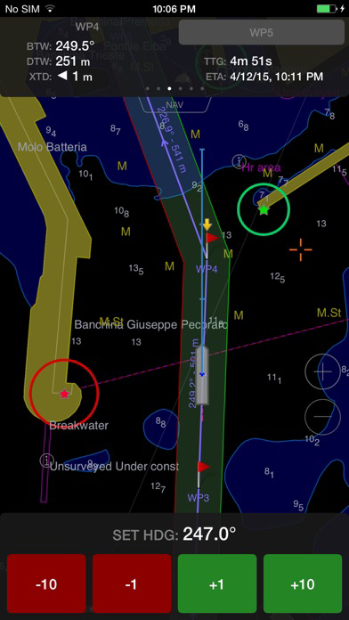
• Schedule information widget in the Route monitoring panel (iPad only)
With this new widget you can estimate planned time of arrival to any selected waypoint of the route by entering the assumed speed-to-go and vice versa.
• New fuel consumption unit introduced: diesel motor ton per hour (mt/h)
Long-requested feature for large boats and yachts.
• Indication of the current chart scale
This feature is available in the lower left corner of the chart area
• Updated marinas sailing guides database
• Updated Tides and Currents database
Bug fixing
• Black chart area screen issue on the 2017 iPad model
• TCP/IP connectivity issue to external sensors over Wi-Fi
Enjoy iSailing and share your feedback with us!
Sincerely Yours,
Transas iSailor team
What's new in the Transas iSailor version 1.9.0
* Bug fixing in relation to the 'black' chart area screen on the New iPad (2017) model
* New: 'Schedule Information' widget in the 'Route Monitoring' panel (iPad only)
* New: Fuel Consumption unit ‘mt/h’ (Diesel motor ton per hour)
* New: actual Chart Scale is indicated right now on the left bottom side
* Sailing Guides database (Marinas) has been updated
Sincerely Yours,
Transas iSailor team
- Improved performance and stability.
- Fix for the Track 'Info' crash (for large recorded tracks only!)
• Advanced Data Logging and Playback option
This functionality allows for the recording and sharing of the following track data between iSailor users:
- NAV: Position, Speed, Course, Heading, ROT, AIS targets, Depth, Wind, etc.
- Selected Route
- Alarms & Settings
The Playback mode can be accessed via the Advanced Track 'Info' submenu.
Check the 'Data Recording' setting in the 'Sensors' menu. Activate the advanced track recording in the 'Monitoring' panel.
• New Sailing Guides
- United States, Inland Waters
- Canada and Northern Atlantic Waters
- South and Latin America
- South Africa and Near East
- Eurasia
- Europe Inland Waters
These are 1-year subscription options (iOS 8.x.x or higher is required)
• New Safety Contour parameter in the 'Chart Settings' menu
• Display of the JHOD Permit # 282511 when Japanese charts are loaded
• *.RTZ format route import added
• Apple Watch support
• The new Battery Level Alarm for the Anchor Watch mode
Minor bug fixes and other improvements
• The Swedish language user interface
• Sensors Multi-Connection via Wi-Fi
Simultaneous connection to the following different data sources:
- NMEA sensors or NMEA multiplexers
- AIS transponder / transceiver or receiver
- Internet AIS data streams
• BRG / DIST data for the cursor position
• New multi-unit for the Ownship and Target Speed: m/s (meters per second)
• Minor bug fixes and other improvements
• NEW!!! Sailing Guides. Regional Marinas.
This option unlocks a detailed information on all the marinas: "South East Asia, Micronesia, Popua New Guinea and Solomon Islands” and "Australia, New Zealand and the islands of the South Pacific Ocean (Polynesia & Fiji, Vanuatu, New Caledonia)" as well as on anchorage places, fishing harbors, boat stations and customs harbors.
These are annual subscription options (iOS 7.x.x or higher is required).
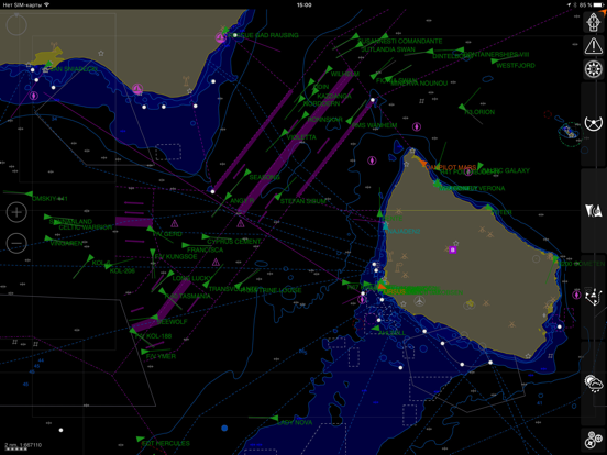
∙ NEW!!! AIS Target table.
The AIS Target table allows for quick real-time table-style filtering and search between hundreds of AIS targets.
∙ NEW!!! The Portugese language support.
∙ NEW!!! Tidal widget (iPad version only).
This functionality enables to display the selected tidal reference point, tidal trend and its current value.
∙ Weather Service enhancement.
It is now possible to save the needed weather parameters for a given region in application so that they can later be used offline. Saving several weather forecasts for different sailing regions is also possible.
∙ Minor bug fixes and other improvements.
In the new version 1.7.5 of Transas iSailor:
• NEW!!! Sailing Guides: USA Pacific. West Coast.
All the USA West Coast marinas, as well as anchorage places, fishing harbors, boat stations and customs harbors. These are annual subscription options (iOS 7.x.x or higher is required).
• NEW!!! Japanese language support.
• NEW!!! Autopilot drift compensation mode. This option makes it possible to compensate for the drift while underway in the autopilot mode. Heading data is necessary for drift compensation. In the Dodge mode it is now possible to monitor the temporary set heading line in the chart area. Corrected data is sent to the autopilot in NMEA messages.
• NEW!!! Ownship Headline function: OFF, By COG, By HDG.
Additionally:
- The length of ‘Text’ type user objects plotted on the chart has been extended up to 30 characters; the same is valid for Waypoint names.
- If necessary, chart folio(s) can now be removed manually using 'Swipe' and 'Delete' commands in the ‘Chart Folios & Updates’ menu item. It is possible to restore afterwards all the folios purchased earlier for a device.
- A new setting in the ‘Chart Settings’ menu item: Zoom Buttons ON/OFF.
- The ‘Anchor Watch radius’ alarm setting value can now be set to up to 600 meters.
Minor bug fixes and other improvements.
In the new version 1.7.4 of Transas iSailor:
• NEW!!! A new chart server has been launched.
Correction updates for all the chart folios purchased earlier are possible only for iSailor 1.7.4 and higher version users.
• NEW!!! NMEA Option - Autopilot
This option enables the user to control the vessel autopilot in both ‘Track’ and ‘Dodge’ modes via Wi-Fi (TCP or UDP connection with the Autopilot is required). Supported NMEA output sentences: APB, BOD, BWC, BWR, HSC, RMB, RMC and XTE. NMEA input rudder angle: RSA.
Make sure that your boat equipment allows such connection and operation!
• NEW!!! MOB functionality
This option enables the user to quickly set and monitor a given point position.
• NEW!!! Sailing Guides. Regional Marinas.
This option unlocks a detailed information on all the marinas: “UK, Iceland and Faroe”, “European marinas (from Gibraltar to Skagerrak)”, “Northern and Central Europe marinas (including Norway, Sweden, Kattegat and Baltic Sea)” and “USA East Coast marinas”, as well as on anchorage places, fishing harbors, boat stations and customs harbors.
These are annual subscription options (iOS 7.x.x or higher is required).
New regions are coming soon!
Additionally:
- New dangerous depth indication method (with a specific red color). This feature can be reached via the ‘Chart Settings’ menu: “Dangerous Depth – On/Off”.
- A new setting in the ‘Sensors’ menu: “Input Checksum Processing – On/Off”.
- A new setting in the “AIS & NMEA Connections” section (only for the UDP connection): ‘Input Port’ and ‘Output Port’.
- Danish language support.
- Tides and Currents functionality has been improved. It is now possible to use negative ‘Minimum Chart Depth’ values.
Minor bug fixes and some other features and improvements.
In the new version 1.7.3 of Transas iSailor:
Minor bug fixes, including ‘Export’ function and some others.
• NEW!!! Tides & Tidal Currents functionality.
The tides calculation in iSailor is performed on the base of four Main harmonics as well as shallow water corrections. The calculation process is based on Simplified Harmonic Method of Tidal Predictions that can be found in different publications, for example Admiralty Tide Tables. This is a 1-year subscription option (Require iOS 7.x.x or higher)
• NEW!!! Sailing Guides. Regional Marinas.
First two regions are available right now! These are ‘Mediterranean Region’ and ‘Caribbean Region’. All marinas are presented as a layer on the chart area and extended info can be taken from any selected marina. 1-year subscription option (Require iOS 7.x.x or higher)
New regions are coming soon!
Additionally:
- New in the ‘Chart Settings’ menu: ‘Show Light Sectors’ – ON/OFF
- New in the ‘Boat Settings’ menu: ‘Own Ship MMSI’. This setting may be used for filtering of the own ship AIS target received via ‘Internet AIS Service’
- Some improvements for the ‘Wind Sensor’ indicator: ‘AWD’ button renamed to ‘AWA’. ‘TWA’ is shown in the “magnifier” mode instead of the ‘TWD’ value. The ‘TWD’ is still available in the standard presentation mode.
… and some other features and improvements
In the new version 1.7.2 of Transas iSailor:
• NEW!!! Tides & Tidal Currents functionality.
The tides calculation in iSailor is performed on the base of four Main harmonics as well as shallow water corrections. The calculation process is based on Simplified Harmonic Method of Tidal Predictions that can be found in different publications, for example Admiralty Tide Tables. This is a 1-year subscription option (Require iOS 7.x.x or higher)
• NEW!!! Sailing Guides. Regional Marinas.
First two regions are available right now! These are ‘Mediterranean Region’ and ‘Caribbean Region’. All marinas are presented as a layer on the chart area and extended info can be taken from any selected marina. 1-year subscription option (Require iOS 7.x.x or higher)
New regions are coming soon!
Additionally:
- New in the ‘Chart Settings’ menu: ‘Show Light Sectors’ – ON/OFF
- New in the ‘Boat Settings’ menu: ‘Own Ship MMSI’. This setting may be used for filtering of the own ship AIS target received via ‘Internet AIS Service’
- Some improvements for the ‘Wind Sensor’ indicator: ‘AWD’ button renamed to ‘AWA’. ‘TWA’ is shown in the “magnifier” mode instead of the ‘TWD’ value. The ‘TWD’ is still available in the standard presentation mode.
… and some other features and improvements
compared to the previous Transas iSailor version 1.7.0:
∙ NEW!!! Ready for iOS 8.x.x! Minimal supported iOS version: 7.x.x and higher
∙ NEW!!! Ready for iPhone 6 and iPhone 6 Plus
∙ NEW!!! NMEA Echo Sounder and Water temperature sensor, including graphical Echogram and 'Sounder Depth' alarm (Optionally)
∙ NEW!!! NMEA Wind sensor including True & Relative Wind calculation (Optionally)
Additionally:
- Extended support of NMEA sentences from Heading sensor (THS, HDT, ROT, VHW, HDM, HDG, VHW)
- ‘Zoom In’ & ‘Zoom Out’ transparent buttons can be enabled for usage in the chart area
- ‘Schedule Information’ window (ETA/TTG) in the Route monitoring page was optimized
- Short distance unit format changed from ‘Cables’ to ‘NM’
- Updated multi-language support for: English, Deutsch, Español, Français, Italiano, Russian, Korean
… and some other features and improvements
Compared to the previous iSailor version 1.6.2:
• NEW!!! Multi-language support: English, Deutsch, Español, Français, Italiano, Russian, Korean, Chinese.
• NEW!!! ‘Internet AIS Service’: real time map view of ships via global AIS Internet Service. This is a 1-year subscription option (Requires iOS 7.x.x and internet availability)
• NEW!!! ‘Weather’: Global coverage real time Weather Forecast. Different weather parameters are supported (Wind Speed & Direction, Pressure, Wave Height, Precipitations). This is a 1-year or monthly subscription option (Requires iOS 7.x.x and internet availability)
• New types of AIS targets are supported: Aids-To-Navigation (AtoN) and Base Stations
• Extended set of symbols for the User Object library (‘Cardinal’ buoys, ‘Service’ symbols)
• Improvements for the Cursor ‘Call Up’ window (ERBL, AIS Target data)
• Improvements for the graphical Route Editing mode (no linkage in ‘Ahead’ plotting mode)
• ‘Boat Dimensions’ settings are optimized
• New colors for following elements: Ownship contour, Motion Vectors, Route
• iPhone interface: more graphics and simplicity
… and some other features and improvements
Compared to the previous iSailor version 1.6.0:
• NEW!!! Multi-language support: English, Spanish, German, Russian, Korean (others coming soon)
• New In-App option ‘NMEA GPS’ sensor and its support via Wi-Fi connection
• New In-App option ‘NMEA Compass & ROT’ sensors and their support via Wi-Fi connection
• New In-App option ‘AIS Ship Contours’ at large chart scales
• Adjusted ‘Anchor Watch’ radius is presented on the chart layer
• Multi Units: Statute Miles and Cables for short distances
• ‘Dangerous Depth’ setting and their presentation in bold font
• “Visible Lighthouses’ by BRG & RNG from the own position
• “GoTo” route via advanced cursor function
• AIS Target Labels (MMSI, NAME, CALL) can be presented on the chart layer
• ‘CPA / TCPA’ alarm and settings for AIS targets
• Head Up chart orientation is available based on NMEA or AIS Compass data
• Calculated Rate-Of-Turn is available based on NMEA or AIS Compass data
• Bridge Elevation is shown on chart
• Photo can be attached to any User Object
• User Object with picture can be exported to Google Earth via KMZ format
• Cursor Position sharing via: Facebook, Twitter, iMessenger, E-Mail
• User Object sharing via: Facebook, Twitter, iMessenger, E-Mail
• Direct access to the iSailor page on Facebook
• ‘Default Fuel consumption’ setting
• ‘Boat Length’ value is increased up to 150 meters
• and some other improvements
• German interface localization fixes
Compared to the previous iSailor version 1.6.0:
• NEW!!! Multi-language support: English, Spanish, German, Russian, Korean (others coming soon)
• New In-App option ‘NMEA GPS’ sensor and its support via Wi-Fi connection
• New In-App option ‘NMEA Compass & ROT’ sensors and their support via Wi-Fi connection
• New In-App option ‘AIS Ship Contours’ at large chart scales
• Adjusted ‘Anchor Watch’ radius is presented on the chart layer
• Multi Units: Statute Miles and Cables for short distances
• ‘Dangerous Depth’ setting and their presentation in bold font
• ‘Visible Lighthouses’ by BRG & RNG from the own position
• ‘GoTo’ route via advanced cursor function
• AIS Target Labels (MMSI, NAME, CALL) can be presented on the chart layer
• ‘CPA / TCPA’ alarm and settings for AIS targets
• Head Up chart orientation is available based on NMEA or AIS Compass data
• Calculated Rate-Of-Turn is available based on NMEA or AIS Compass data
• Bridge Elevation is shown on chart
• Photo can be attached to any User Object
• User Object with picture can be exported to Google Earth via KMZ format
• Cursor Position sharing via: Facebook, Twitter, iMessenger, E-Mail
• User Object sharing via: Facebook, Twitter, iMessenger, E-Mail
• Direct access to the iSailor page on Facebook
• ‘Default Fuel consumption’ setting
• ‘Boat Length’ value is increased up to 150 meters
• and some other improvements
Compared to the previous iSailor version 1.5.7:
• New Graphic User Interface
• The Compass Rose control, with COG/SOG indicators and Bearing To Waypoint mark (iPad only)
• Variable length for the Ownship and AIS targets vectors
• Boat dimensions and GPS reference point on large scales
• Ownship ERBL – fixed and movable modes
• Extended “Route” functionality, including Focus and Searching functions
• Turn Radiuses can be adjusted for all WPs separately
• Course and Distance presentation on the route legs
• Extended “User Objects” database, including Import & Export functionality
• Extended “Track” functionality, including Focus and Searching functions
• Positioning System Accuracy, native XTD Bar (iPad only)
• ETA / TTG calculation to current WP or to any selected WP ahead
• and many others