Improved new Vector text rendering
GPS reception display improvements
POI language improvements
Heading and speed filter improvements
Track sharing issues resolved
Size setting for heading line, speed and heading display size
AIS rate of turn display improvements
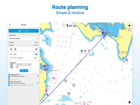
VMG usage for ETA calculation
Autorouting download management in My Charts
Decimal seperation improvements in settings
Vector Feet / Meter improvements
# 365-day licence with access to all NV Charts App services and functions with paper charts or as in-app purchase
# Let us know what you think: support@nvcharts.com
# Autorouting enhancement in calculations and coverage improvements for European waters.
# Internal GPS enhancements.
# Velocity made good (VMG) in expert mode for a better knowledge of the speed to the next waypoint along your route.
# Improved chart update management.
# Overzoom display warning.
# 365-day licence with access to all NV Charts App services and functions with valid edition paper charts or as in-app purchase.
# Let us know what you think: support@nvcharts.com
# Autorouting enhancement in calculations and coverage improvements for European waters.
# Velocity made good (VMG) in expert mode for a better knowledge of the speed to the next waypoint along your route.
# Improved chart update management.
# Overzoom display warning.
# 365-day licence with access to all NV Charts App services and functions with paper charts or as in-app purchase
# Let us know what you think: support@nvcharts.com
# Autorouting enhancement in calculations and coverage improvements for European waters.
# Velocity Made Good (VMG) in expert mode for a better knowledge of the speed to the next waypoint along your route.
# Improved chart update management.
# 365-day licence with access to all NV Charts App services and functions with paper charts or as in-app purchase
# Let us know what you think: support@nvcharts.com
# TCP/UDP switch reconnect improvement
# iOS 15 improvements, note that we are still waiting for iOS 15.1+ to be released to fix iOS bugs of version 15.0.1+
# iOS 14 fix
# 365-day licence with access to all NV Charts App services and functions with paper charts or as in-app purchase
# Let us know what you think: support@nvcharts.com
# TCP/UDP switch reconnect improvement
# iOS 15 improvements, note that we are still waiting for iOS 15.1+ to be released to fix iOS bugs of version 15.0.1+
# 365-day licence with access to all NV Charts App services and functions with paper charts or as in-app purchase
# Let us know what you think: support@nvcharts.com
# AIS enhancements
# 365-day licence with access to all NV Charts App services and functions with paper charts or as in-app purchase
# Let us know what you think: support@nvcharts.com
# GPS acquisition improvements
# Let us know what you think: support@nvcharts.com
# Add autoroute* waypoint enhancement
# Ruler lock on boat
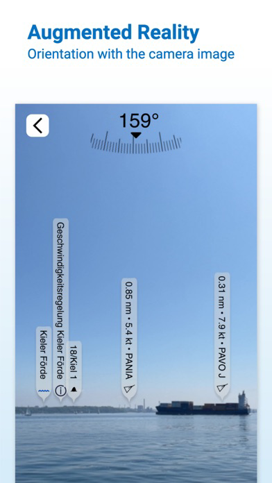
# Augmented Reality live position display
# Message centre enhancement
# Lock north
# 365-day licence with access to all NV Charts App services and functions with paper charts or as in-app purchase
# Let us know what you think: support@nvcharts.com
*available in the Western Baltic, German North Sea, Netherland, and German Inland Waters
# 7 day trials
# Augmented Reality (AR) View
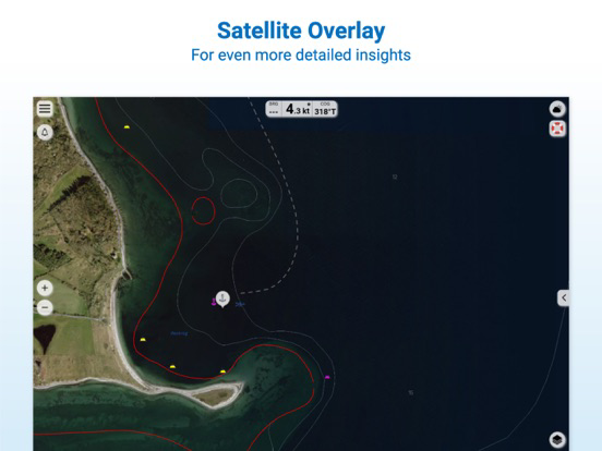
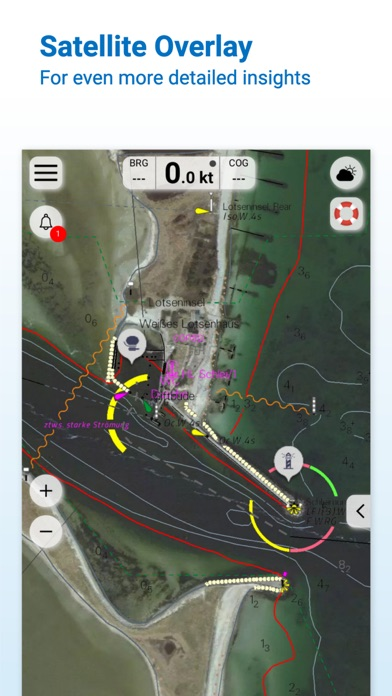
# Satellite images layer
# Easy layer toggle
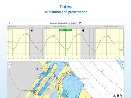
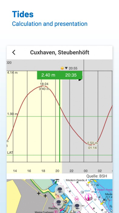
# Date selection tides
# Night mode improvements
# Message center
# 365-day licence with access to all NV Charts App services and functions with paper charts or as in-app purchase
# Autorouting improvements*
# NMEA AIS UDP
# Let us know what you think: support@nvcharts.com
*available in the Western Baltic, German North Sea, Netherland, and German Inland Waters
# Stability improvement
# Augmented Reality (AR) View
# Satellite images layer
# Easy layer toggle
# Date selection tides
# Night mode improvements
# Message center
# 365-day licence with access to all NV Charts App services and functions with paper charts or as in-app purchase
# Autorouting improvements*
# NMEA AIS UDP
# Let us know what you think: support@nvcharts.com
*available in the Western Baltic, German North Sea, Netherland, and German Inland Waters
# Augmented Reality (AR) View
# Satellite images layer
# Easy layer toggle
# Date selection tides
# Night mode improvements
# Message center
# Autorouting improvements
# NMEA AIS UDP
# Let us know what you think: support@nvcharts.com
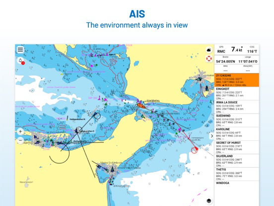
AIS improvements in combination with internal sensor and tags
AIS own ship display selection improvement
Fixed track storage problem with some devices
Added data management settings and improved start time
Dashboard AIS scroll
AIS: Red highlight for collision CPA less than 250m in chart display an AIS target list in the dashboard
iPad Pro 2020 issue with the activation of vector charts fix
Routes sorting improvements
Autoroute Switch improvement
POI notification timing improvements
Minor improvements
AIS: Red highlight for collision CPA less than 250m in chart display an AIS target list in the dashboard
iPad Pro 2020 issue with the activation of vector charts fix
Routes sorting improvements
Autoroute Switch improvement
POI notification timing improvements
Minor improvements
- Search function
- Improved logbook and track recording with sharing and download
- Autorouting (NL,DE, DK, SE + other regions to follow soon)
- The current charts already show the planned new traffic separation areas in the Baltic Sea.
- Free online nautical chart preview for planning
- Community Layer / Points of Interest(POI)
- Background anchor alarm
Tide prediction fix
Language settings fix
AIS disconnecting improvements
Internet connection check improvements
Track recording with logging indication in top menu
Speed display improvements
Chart loading improvements following ship
Dashboard swipe
Own ship and AIS targets display improvements
Bearing tool in quick menu
Basemap loading improvements
Chart manager improvements
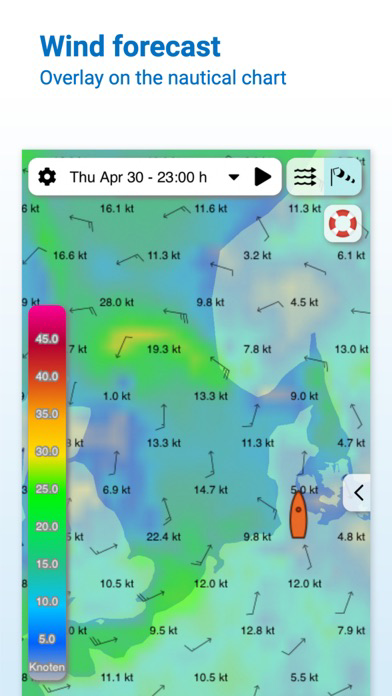
Wind scale with units
Wind and Current data saving issue
Coordinates in at location menu
Bugfixes
## Bugfixes for
## Language initializing
## Grey screens
## Chart download issues
## New App Design
## In App Purchase for digital charts and updates for charts
## Easy routing
## Logbook with pictures
## Markers with pictures
## Improved automatic chart selection
## Online Charts as preview
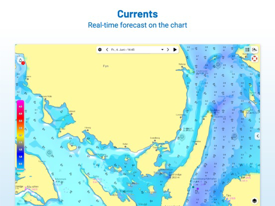
## Real time ocean currents for German North Sea and Baltic Sea and Gulf Stream
## In App Purchase for digital charts
## Track logging issues fixed / Hotfix Internal GPS NMEA cooperation
## Real time ocean currents for German North Sea and Baltic Sea and Gulf Stream
## In App Purchase for digital charts
## Track logging issues fixed