Sea Level Rise
Sea Level Rise Capturing Tool
Free
3.0.5for iPhone, iPad and more
Age Rating
Sea Level Rise Screenshots
About Sea Level Rise
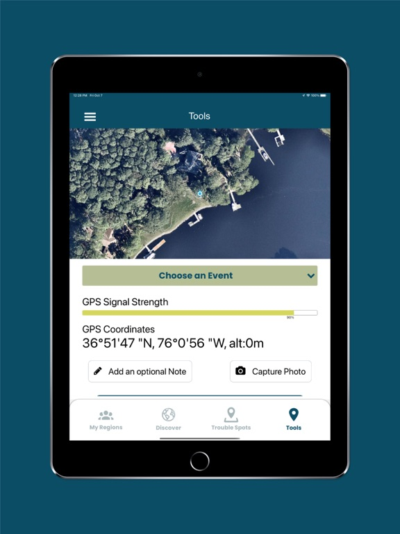
The Sea Level Rise app allows anyone to map the flooding in their community, helping document sea level rise and other flooding impacts.
While virtually everyone in and around a low-lying coastal region is or will be affected by sea level rise, we started our work in Hampton Roads, Virginia and have learned from the mapping efforts of thousands of volunteers during annual "Catch the King Tide" events. Developed by Wetlands Watch, this app moves us in the direction of being a better informed and connected community so we can stay ahead of sea level rise.
Access user-submitted information about this global phenomena and participate (as a volunteer) in capturing the street-level data we need to better understand and solve the challenges it brings! With the app, you can:
• Participate in crowd-sourcing events to capture the localized data researchers and civic leaders require, but lack
• Find and add nearby "Trouble" spots where high water affects your travel during times of inclement weather
• Capture and share photos that document what's occurring in your community
• Access specific collaboration spaces, called regions, where you can manage volunteers and schedule mapping events
Show More
What's New in the Latest Version 3.0.5
Last updated on Jan 17, 2024
Old Versions
Added the following feature,
- Implement the pin clustering in region listing -> region detail -> mapping -> Pins screen.
- Handle large amount of data Implement the data to pin to handle large amount of data.
- Implement the pin clustering in region listing -> region detail -> mapping -> Pins screen.
- Handle large amount of data Implement the data to pin to handle large amount of data.
Show More
Version History
3.0.5
Jan 17, 2024
Added the following feature,
- Implement the pin clustering in region listing -> region detail -> mapping -> Pins screen.
- Handle large amount of data Implement the data to pin to handle large amount of data.
- Implement the pin clustering in region listing -> region detail -> mapping -> Pins screen.
- Handle large amount of data Implement the data to pin to handle large amount of data.
3.0.4
Nov 3, 2023
- Minor app functionalities fixing
3.0.3
Sep 20, 2023
- Minor app functionalities fixing.
3.0.2
Sep 13, 2023
- Minor fixing and UI changes.
3.0.1
Oct 21, 2022
- Minor Improvements
3.0.0
Oct 12, 2022
Sea Level Rise 3.0.0 is a major update which includes:
• An “Official” region filter to find approved regions and events
• Filter mapping events by date and location
• New graphics and color scheme
• An “Official” region filter to find approved regions and events
• Filter mapping events by date and location
• New graphics and color scheme
2.0.1
Oct 26, 2016
This app has been updated by Apple to display the Apple Watch app icon.
In 2.0.1, creating a new region sets the country properly. Sea Level Rise 2.0 is a major update which allows anyone in the world to begin mapping sea level rise! We started in Hampton Roads, Virginia and have learned from the mapping efforts of 1,000s of volunteers along the U.S. coast. In this updated release you can start a regional group, schedule your own mapping events, and use GPS tools to contribute data points for weather and tide events. Since we have made many improvements to the scope of the app, existing users are being asked to sign up again to be able to manage and participate in their own regional groups. We look forward to future mappings with you!
In 2.0.1, creating a new region sets the country properly. Sea Level Rise 2.0 is a major update which allows anyone in the world to begin mapping sea level rise! We started in Hampton Roads, Virginia and have learned from the mapping efforts of 1,000s of volunteers along the U.S. coast. In this updated release you can start a regional group, schedule your own mapping events, and use GPS tools to contribute data points for weather and tide events. Since we have made many improvements to the scope of the app, existing users are being asked to sign up again to be able to manage and participate in their own regional groups. We look forward to future mappings with you!
2.0.0
Oct 3, 2016
Sea Level Rise 2.0 is a major update which allows anyone in the world to begin mapping sea level rise! We started in Hampton Roads, Virginia and have learned from the mapping efforts of 1,000s of volunteers along the U.S. coast. In this updated release you can start a regional group, schedule your own mapping events, and use GPS tools to contribute data points for weather and tide events. Since we have made many improvements to the scope of the app, existing users are being asked to sign up again to be able to manage and participate in their own regional groups. We look forward to future mappings with you!
1.0.1
Oct 12, 2015
Updated for iOS9.
The app has a new look, a GPS history tool, and bug fixes.
The app has a new look, a GPS history tool, and bug fixes.
1.0.0
Jun 23, 2014
Sea Level Rise FAQ
Click here to learn how to download Sea Level Rise in restricted country or region.
Check the following list to see the minimum requirements of Sea Level Rise.
iPhone
Requires iOS 10.0 or later.
iPad
Requires iPadOS 10.0 or later.
iPod touch
Requires iOS 10.0 or later.
Sea Level Rise supports English


