Soil Explorer
Free
2.1.4for iPhone, iPad and more
8.5
6 Ratings
Purdue University
Developer
180.5 MB
Size
Apr 1, 2024
Update Date
Education
Category
4+
Age Rating
Age Rating
Soil Explorer Screenshots
About Soil Explorer
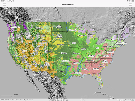
Explore detailed maps of soil properties and landscapes for various U.S. states, as well as small-scale maps of soil distributions for the world. Examine the details for a specific area, but also see the overview for a large area. Learn how features shown on the maps correspond to what you observe in the field.
Soil Explorer utilizes detailed soil survey data from the USDA Natural Resources Conservation Service and data and maps from the U. S. Geological Survey and other sources to produce informative, highly engaging maps. These maps are designed to show the complex interrelationships between soil properties and the landscapes in which soils occur.
Show More
What's New in the Latest Version 2.1.4
Last updated on Apr 1, 2024
Old Versions
Updated help content.
Show More
Version History
2.1.4
Apr 1, 2024
Updated help content.
2.1.3
Mar 29, 2024
Bug fixes.
2.1.2
Mar 26, 2024
Location search. Support for an active overlay feature that allows queryable soil polygons and field trip routes to be displayed on top of any thematic map.
2.0.1
Aug 12, 2020
Completely new and redesigned app that is faster and more responsive and now works on both iPad and iPhone. New, icon-driven interface that can be accessed from either the right or left side of the screen. Scale bar. Slide out shows GPS latitude, longitude and elevation. Support for Spanish.
2.0.0
Jul 27, 2020
Completely new and redesigned app that is faster and more responsive and now works on both iPad and iPhone. New, icon-driven interface that can be accessed from either the right or left side of the screen. Scale bar. Slide out shows GPS latitude, longitude and elevation. Support for Spanish.
1.5.1
Jun 2, 2017
Renamed the app to better reflect its content.
Bug fixes.
Bug fixes.
1.5
Jun 28, 2016
•Map queries are now supported for online maps. If a map is formatted for queries, a tap on the map will open a popup with the map unit name. Some maps also have additional descriptive information. Queries are not supported for local maps.
•The configuration file is now online so that additional online maps and overlays can be added as they come available.
•Added USGS Imagery, USGS Topo, and USGS National Hydrography Dataset (NHD) maps from the USGS The National Map.
•Numerous bug fixes.
•The configuration file is now online so that additional online maps and overlays can be added as they come available.
•Added USGS Imagery, USGS Topo, and USGS National Hydrography Dataset (NHD) maps from the USGS The National Map.
•Numerous bug fixes.
1.0
May 29, 2015
Soil Explorer FAQ
Click here to learn how to download Soil Explorer in restricted country or region.
Check the following list to see the minimum requirements of Soil Explorer.
iPhone
Requires iOS 14.7 or later.
iPad
Requires iPadOS 14.7 or later.
iPod touch
Requires iOS 14.7 or later.
Soil Explorer supports English, Spanish