Aqua Map Boating
Marine navigation and fishing
免費Offers In-App Purchases
37.8for iPhone, iPad and more
Age Rating
Aqua Map Boating 螢幕截圖
About Aqua Map Boating
Start Your 14-Day Free Trial on All Subscriptions Today
Get the latest charts you can use offline, weather, tides and POIs from ActiveCaptain and Waterway Guide.
Connect AIS and your boat GPS and instruments data via WiFi connection. Plan routes, record your tracks, find new friends on the water and share your data across the Live Sharing community.
THE MOST ADVANCED MARINE NAVIGATION APP
• Optimised for both iPhone and iPad with multi-screen mode
• Vector and raster nautical charts for offline use, updated regularly
• Satellite image
• Routes/Tracks navigation with real-time information on bridges, hazards, and best fuel prices
• Manual route planning
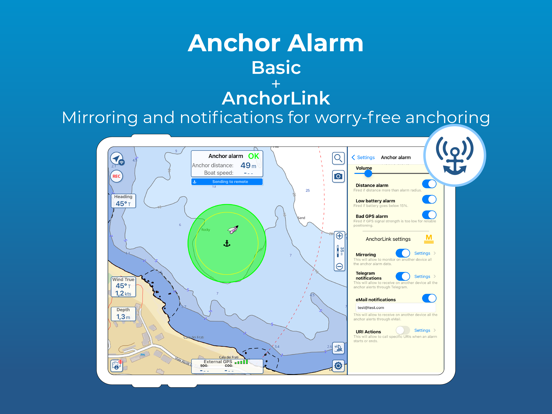
• Basic anchor alarm and AnchorLink with mirroring and email/telegram notifications
• Marine Forecasts for wind, waves, currents and worldwide weather information
• 1800+ Weather buoys to get real time sea info
• Tide & Current predictions and simulations
• USACE surveys and USCG List of lights
• 14000+ vector lake maps
• Easy sharing and uploading of tracks, markers and routes
• Live Sharing-Aqua Map community to find new friends on the water
• ActiveCaptain & Waterway Guide community integration
• Real time display of NMEA instruments (depth sounder, wind sensor, compass, GPS)
• AIS target display with automatic collision detection
• Powerful search with advanced settings
• Light/Dark display
• Optimised battery usage
► NAUTICAL CHARTS
Official NOAA charts complete with depth contours, navigation markers, buoys, lights and other chart features. You can download the maps at home on all your devices and use them on the boat offline (no internet connection required).
► ROUTES and WAYPOINTS
Plan your trip, insert and edit waypoints. Navigate your route and your track, monitor distance, time (ETA), course and heading to next waypoint or your final destination.
► ANCHOR ALARM
Set the anchor position and drift radius and monitor in real time. If the GPS position is outside the defined range, an acoustic alarm is sounded and a visual alarm is displayed. Low battery and bad GPS reception alarms are also available.
► TIDES & CURRENTS
You can calculate the prediction for more than 7500 stations in US, Canada, Bahamas & Australia. See the T&C trend on the map and simulate any future date.
► LOADING and SHARING
You can share your favorite's markers on Facebook or send an email with your last daily track. Not only, you can also load any KML, KMZ, GPX found in internet or received from your friends.
► COMMUNITIES
Join “Live Sharing” and become part of Aqua Map community: find new friend on the water, chat and send your data to anyone without leaving the app.
Access tens of thousands of points of interests and reviews all over the world from ActiveCaptain and Waterway Guide communities.
► AQUA MAP MASTER
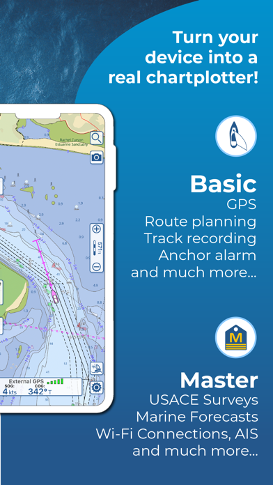
Transform your device into a chartplotter:
• Most updated USACE surveys and USCG List of Lights
• Marine forecasts (wind, waves, currents and weather)
• AnchorLink with mirroring and telegram/email notifications
• Connect NMEA (and SignalK) devices through WiFi and use instrument and AIS data all across the app (navigation and anchor alarm)
• Display AIS targets on the chart with automatic collision detection
• Route Explorer with real-time information on bridges, hazards, and best fuel prices
(Note: This subscription includes extra features but does not include cartography; it must therefore be paired with a cartography subscription)
► TYPE OF PURCHASES
Unlimited: download and update forever (available only for some subscription)
Subscription: one year auto-renewable subscription. The payment will be made through your (Apple ID) account. The subscription will renew automatically unless cancelled at least 24 hours before the expiration. The user can manage their subscription and turn off auto-renewal in the Apple ID Account Settings section after purchase.
Terms of Service: https://www.aquamap.app/terms-and-conditions
Privacy Policy: https://www.aquamap.app/privacy-policy
Show More
最新版本37.8更新日誌
Last updated on 2024年04月10日
歷史版本
+ Small improvements to always have the most reliable application
Show More
Version History
37.8
2024年04月10日
+ Small improvements to always have the most reliable application
37.7
2024年04月08日
+ Added State and County boundaries
+ Small improvements to always have the most reliable application
+ Small improvements to always have the most reliable application
37.6
2024年03月25日
+ Small improvements to always have the most reliable application
37.5
2024年03月20日
+ Small improvements to always have the most reliable application
37.4
2024年02月29日
+ Small improvements to always have the most reliable application
37.3
2024年02月07日
+ Small improvements to always have the most reliable application
37.2
2024年01月31日
+ Small improvements to always have the most reliable application
37.1
2024年01月23日
+ Small improvements to always have the most reliable application
37.0
2024年01月17日
+ Small improvements to always have the most reliable application
36.9
2024年01月16日
+ Small improvements to always have the most reliable application
36.8
2024年01月15日
+ Small improvements to always have the most reliable application
36.7
2024年01月05日
+ Small improvements to always have the most reliable application
36.6
2023年12月16日
+ Added support for StrikeLines 3D Charts
+ Added the possibility to split a track in 2 parts
+ Small improvements to always have the most reliable application
+ Added the possibility to split a track in 2 parts
+ Small improvements to always have the most reliable application
36.5
2023年11月27日
+ Small improvements to always have the most reliable application
36.4
2023年11月10日
+ Some small improvements
36.3
2023年11月06日
+ Some small improvements
36.2
2023年10月19日
+ Some small improvements
36.0
2023年09月12日
+ Added the Canadian Coast Guard NAVWARNs data, updated daily
+ Added Wind, Depth and Heading mirroring in the AnchorLink function
+ Added Wind, Depth and Heading mirroring in the AnchorLink function
35.5
2023年09月04日
+ Some minor fixing
35.4
2023年08月30日
+ Added Finland, Fiji and Vanuatu charts
+ Some minor fixing
+ Some minor fixing
35.3
2023年07月18日
+ Now you can purchase and use the StrikeLInes HardBottomHD fishing charts
+ Some small improvement and fixing
+ Some small improvement and fixing
35.2
2023年06月26日
+ Some small improvement and fixing
35.1
2023年06月19日
+ Some small improvement and fixing
35.0
2023年06月06日
New feature: Public Folder !!!
Now you have a new way to share your data with the entire Aqua Map community. Put your data in the new "public" folder in your GEC Account and everyone will be able to access it and keep the data synced through your Live Sharing page.
Now you have a new way to share your data with the entire Aqua Map community. Put your data in the new "public" folder in your GEC Account and everyone will be able to access it and keep the data synced through your Live Sharing page.
34.3
2023年05月11日
+ Some small improvements and bug fixing
Aqua Map Boating FAQ
點擊此處瞭解如何在受限國家或地區下載Aqua Map Boating。
以下為Aqua Map Boating的最低配置要求。
iPhone
須使用 iOS 12.0 或以上版本。
iPad
須使用 iPadOS 12.0 或以上版本。
iPod touch
須使用 iOS 12.0 或以上版本。
Aqua Map Boating支持德文, 意大利文, 法文, 英文, 荷蘭文, 葡萄牙文, 西班牙文
Aqua Map Boating包含應用內購買。 以下為Aqua Map Boating應用內購買價格清單。
Aqua Map Master
$14.99
US - Nautical & Lakes charts
$9.99
Florida - NOAA Nautical chart
$4.99
Bahamas - Explorer Charts
$49.99
US & Canada - Nautical chart
$14.99
Virginia to Georgia - Charts
$4.99
Cape Cod to Chesapeake Charts
$4.99
New England - Nautical charts
$4.99
US & Canada - Nautical chart
$49.99
Caribbean South Nautical chart
$14.99


