Aqua Map Wisconsin Lakes GPS +

Aqua Map Wisconsin Lakes GPS +


Fishing & Boating depth charts


$9.99

9.2for iPhone, iPad
8.5
6 Ratings
GEC s.r.l.
Developer
2018年04月03日
Update Date
Navigation
Category
Age Rating
4+
Apps in this category do not contain restricted content.
9+
Apps in this category may contain mild or occasional cartoon, fantasy or real-life violence, as well as occasional or mild adult, sexually suggestive or horrifying content and may not be suitable for children under 9 years of age.
12+
Apps in this category may contain occasional mild indecent language, frequent or intense cartoon or real-life violence, minor or occasional adult or sexually suggestive material, and simulated gambling, and may be for children under 12 years of age.
17+
You must be at least 17 years old to access this App.
Apps in this category may contain frequent and intense offensive language; Frequent and intense cartoon, fantasy or realistic violence: frequent and intense adult, scary and sexually suggestive subjects: as well as sexual content, nudity, tobacco, alcohol and drugs, may not be suitable for children under 17 years of age.
Aqua Map Wisconsin Lakes GPS + 螢幕截圖
Aqua Map Wisconsin Lakes GPS + 海報Aqua Map Wisconsin Lakes GPS + 海報Aqua Map Wisconsin Lakes GPS + 海報Aqua Map Wisconsin Lakes GPS + 海報Aqua Map Wisconsin Lakes GPS + 海報Aqua Map Wisconsin Lakes GPS + 海報

About Aqua Map Wisconsin Lakes GPS +

An app to satisfy all your Fishing and Boating's needs, developed with the help of professional fishermen.
► CHECK YOUR LAKE HERE BEFORE YOU BUY!: http://www.globalaquamaps.com/WIViewer.html
You will be able to download the best maps and enjoy your new fishing season. Press the RECORD button, put the phone in your pocket and record your fishing trolling track....and much more.

►► Features:
• Optimised for both iPhone and iPad use.
• Amazingly clear nautical charts, thanks to the Retina technology usage.
• 150 Wisconsin lakes available, plus a complete topographic map to reach the most remote lakes and rivers.
• You can download maps (for FREE, no additional purchase is required) on the device, to be used later without any internet connection.
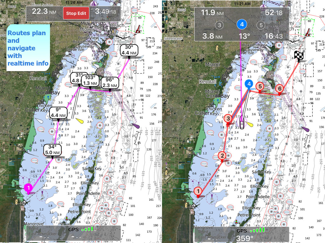
• Plan and navigate your ROUTE
• *** NEW *** Expand your horizons with mapXpan (patent pending).
• Easy to use.
• Optimized battery usage with battery consumption monitoring; up to 14 hours continuous track.
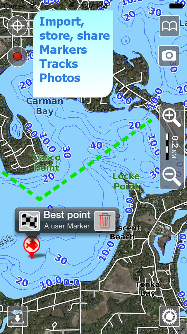
• Share tracks, markers, routes and pictures in various formats (KMZ and GPX).
• Store an unlimited number of tracks, markers and routes.
• Customize your Marker's icon and Track's color.
• Switch between Map display modes (Offline, Satellite, Roads).
• Measure distances on the map.
• Load any track, marker and route from internet communities (KMZ, KML, GPX also if zipped)
• Query map objects with your finger tip
• Search map objects around you or search places by name worldwide 

► FUTURE UPDATES
This app, for technical reasons, will not be updated in the future. The new FREE app called "Aqua Map Lakes - Fishing charts" is going to substitute it with the relative inApp purchases for over 10,000 lakes in USA and Canada.

► MAPS
Aqua Map lets you download - for FREE!! - maps with depth contours, boat ramps, etc. but also a complete Topographic map with road network, trails, elevation contours, lakes, rivers, etc. and all it is necessary to enjoy your best outdoor experience. No additional purchase is required. You can download the maps at home within your device and then use them on the boat without any Internet connection.

► SHARING
Why do not sharing your favorite's markers on Facebook or sending an email with your last daily track, with all the pictures you captured to show them on a PC ? With Aqua Map it is just a click.

► ROUTES and WAYPOINTS
Plan your trip, insert and edit waypoints. Navigate your route and monitor distance, time and direction toward your next waypoint.

► LOADING OTHER's TRACKS, ROUTES AND MARKERS
Aqua Map can load any KML, KMZ, GPX (also zipped) you can find over the internet or received from your friends. You can load tracks and markers generated from any application (e.g. Google EarthTM, Maps, or other iPhone/iPad apps), obviously including Aqua Map, or any device (e.g. Garmin, Nuvi, Magellan, etc.).

► OPTIMIZED BATTERY USAGE
Unlike many other apps, Aqua Map is designed to use at the best the battery power. Its Battery Consumption Monitoring will stop the track recording when the battery is too low, in order to ensure the phone is still usable at the end of your outdoor's day.

► iOS BACKGROUND MODE
Aqua Map works also when in background, you can receive/make calls and messages while the track recording is running.

————

Like any GPS, the signal quality can vary very much depending by the amount of visible sky, foliage, weather condition, etc. GPS is not reliable indoor.

The continuous GPS usage, also in background, can drastically reduce the battery life.
Show More

最新版本9.2更新日誌

Last updated on 2018年04月03日
歷史版本
IMPORTANT: this is the LAST update for this app. For technological reasons we cannot update it any longer. If you would like to stay aligned with the state-of-art of technology you should download the FREE "Aqua Map Lakes - Fishing Charts". The area you purchased with your current Aqua Map app will be automatically transferred into the FREE app after you install this update, so you will continue to enjoy it and its updates, without any additional expense.
Show More
Version History
9.2
2018年04月03日
IMPORTANT: this is the LAST update for this app. For technological reasons we cannot update it any longer. If you would like to stay aligned with the state-of-art of technology you should download the FREE "Aqua Map Lakes - Fishing Charts". The area you purchased with your current Aqua Map app will be automatically transferred into the FREE app after you install this update, so you will continue to enjoy it and its updates, without any additional expense.
8.3.5
2018年01月03日
• Greatly improved Map Info pop-up, adding the possibility to select and manage multiple objects.
• Added the option to search Aqua Map Lakes (lakes with depth details) in the Search page.
• Improved the Around You tab in the Search page, now you can search and manage also User Data and Aqua Map Lakes
• Added date and time for track in the Map Info popup
• Now Track and Route line width can be changed in the Settings
• Some small improvements
8.2.5
2017年11月28日
- iOS 11, iPhone X and iPhone 8 compatible
- Solved an issue when taking photos from inside the App
- Minor improvements
8.1
2017年11月16日
- iOS 11, iPhone X and iPhone 8 compatible
- Added ETA for Routes
- Added GPS Direction/Compass option for Heading Up Mode
- Minor improvements
7.1
2017年06月01日
- We introduce a new exclusive way to display the maps: mapXpan.
This new functionality will greatly expand your display; you will have the details you need for a safe navigation seamlessly integrated with a large overview area.
7.0.2
2017年05月03日
• Improved drawing speed on detailed zoom
7.0
2017年04月21日
• We added the option to enable/disable the land data overlay
6.2.1
2016年12月20日
- Small improvements to benefit fully from iOS10
- Minor fixing
6.1
2016年08月30日
- Added a new option to permanently store Offline Maps avoiding removal by the automatic iOS memory clean-up in case of low disk space.
- Improved speed graph to draw data accordingly to unit of measure selected
- Bug Fixing and optimizations
6.0.10
2016年06月04日
- The map drawing has been greatly improved with a new 3D map style perception.
- We updated all the maps adding more details
- Minor improvements
5.5
2016年02月02日
• Improved Active Captain data management
• Minor improvements
5.4
2015年11月25日
• Improved gps tracking in background
5.3
2015年10月21日
• IOS 9 Compatibility
• Added possibility to select map tiles to be canceled from disk
• Added possibility to reverse a route
• The product is now available for both iPhone and iPad
5.1
2015年08月22日
• ActiveCaptain routes sync: store your Routes into the ActiveCaptain community to share with other users and with all your devices, keep your Aqua Map in sync with your Active Captain Account.
• Improved compatibility with Facebook for data upload.
5.0
2015年07月01日
Your App is now integrated with your GEC Account to archive your experiences and share them with friends ... manage your tracks, photos, markers and tours on a PC ... get any GPS file from internet, friends and communities ... modify and create your own itineraries ... load them on this App to be used for your next trip !
4.5.1
2015年06月15日
Improved backward compatibility with IOS 7
4.4
2015年05月26日
• Improved user data sharing
4.3
2015年03月25日
• Sharing of sets of objects
• Optimized support for 64 bit platforms
• New function for setting transparency on map overlays
• Bug fixing
3.5
2014年11月12日
Fixed an issue with ActiveCaptain sometime loosing the connection
Fixed a crash during device rotation
3.4
2014年09月28日
• iOS8 Compatibility
• Solved issue app blocked in some cases after 3.3 update
• Minor fixing on Facebook sharing
3.3
2014年08月28日
• Improved stand-by management
• Fixed an issue with the display of some AciveCaptain reviews
• Added search of ActiveCaptain POIs
3.2
2014年08月15日
ActiveCaptain Community integration:
Join the community of more than 100.000 boaters who write reviews, update data and provide up to date hazard information on ActiveCaptain
3.1
2014年07月02日
• Capability to insert and edit the WayPoints of a Route by coordinates
• Advanced sharing on Facebook and Twitter, now you can see the shared markers,routes and tracks directly drawn on our web viewer
• Minor Bug Fixing
3.0
2014年06月04日

Aqua Map Wisconsin Lakes GPS + FAQ

點擊此處瞭解如何在受限國家或地區下載Aqua Map Wisconsin Lakes GPS +。
以下為Aqua Map Wisconsin Lakes GPS +的最低配置要求。
iPhone
iPad
Aqua Map Wisconsin Lakes GPS +支持Dutch, English, French, German, Italian, Portuguese, Spanish

Aqua Map Wisconsin Lakes GPS +相關應用

你可能還喜歡

GEC s.r.l. 開發者的更多應用