River Thames Guide Lite

River Thames Guide Lite


Free

24.3for iPhone, iPad and more
Jeff Maynard
Developer
104 MB
Size
Mar 7, 2024
Update Date
Navigation
Category
4+
Age Rating
Age Rating
4+
Apps in this category do not contain restricted content.
9+
Apps in this category may contain mild or occasional cartoon, fantasy or real-life violence, as well as occasional or mild adult, sexually suggestive or horrifying content and may not be suitable for children under 9 years of age.
12+
Apps in this category may contain occasional mild indecent language, frequent or intense cartoon or real-life violence, minor or occasional adult or sexually suggestive material, and simulated gambling, and may be for children under 12 years of age.
17+
You must be at least 17 years old to access this App.
Apps in this category may contain frequent and intense offensive language; Frequent and intense cartoon, fantasy or realistic violence: frequent and intense adult, scary and sexually suggestive subjects: as well as sexual content, nudity, tobacco, alcohol and drugs, may not be suitable for children under 17 years of age.
River Thames Guide Lite Screenshots
River Thames Guide Lite posterRiver Thames Guide Lite posterRiver Thames Guide Lite posterRiver Thames Guide Lite posterRiver Thames Guide Lite posterRiver Thames Guide Lite posterRiver Thames Guide Lite posterRiver Thames Guide Lite poster
River Thames Guide Lite posterRiver Thames Guide Lite posterRiver Thames Guide Lite posterRiver Thames Guide Lite posterRiver Thames Guide Lite posterRiver Thames Guide Lite posterRiver Thames Guide Lite poster

About River Thames Guide Lite

The complete planner and guide for travel and leisure on the River Thames (from its source to the Thames Barrier) and the Wey Navigation including where you can go, how you get there and what’s on the way - includes these key features:

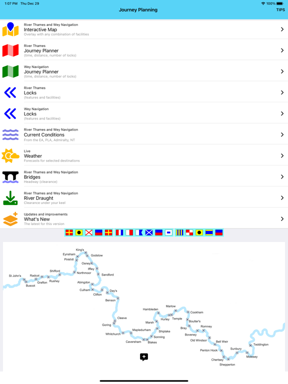
Thames Map and Guide:
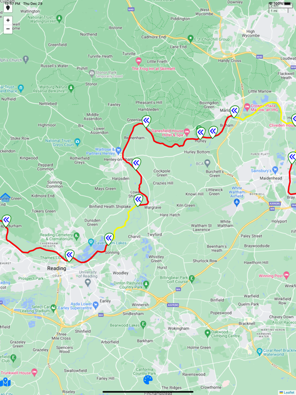
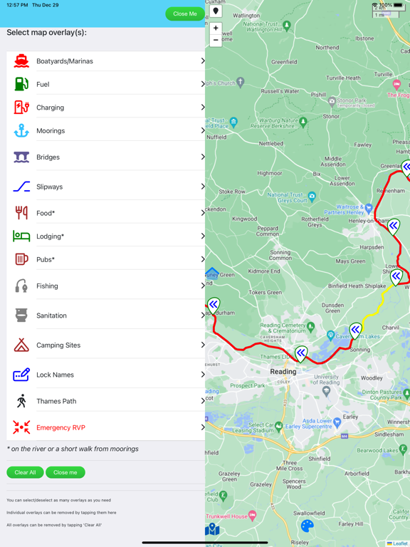
•Interactive River Map*
•Journey Planner: time (at 5, 3 , 1 mph), distance and number of locks between any two of 102 River Thames points (45 on Wey)
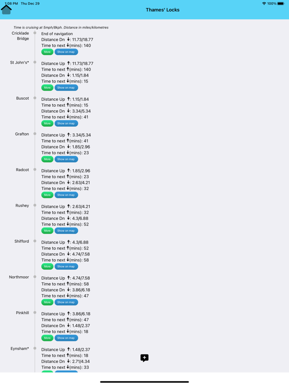
•Locks: need to know detail on every lock
•Bridges: headway in metres and feet
•River draught (depth of water)
•Weather for selected locations*
•Current river conditions (non-tidal and tidal)*

Boating Advice:
•Rules for the River
•Preventing Problems
•Emergency Help and Guidance (RNLI approved)

INTERACTIVE RIVER MAP*: pinch or squeeze to zoom to the required level of detail. Add any combination of locks, moorings, boatyards, fuel, marinas, pubs, restaurants, lodgings, sanitation, fishing, emergency RVP and/or bridges; tapping any icon pops up further details including phone number, post code, maximum stay etc (where available).

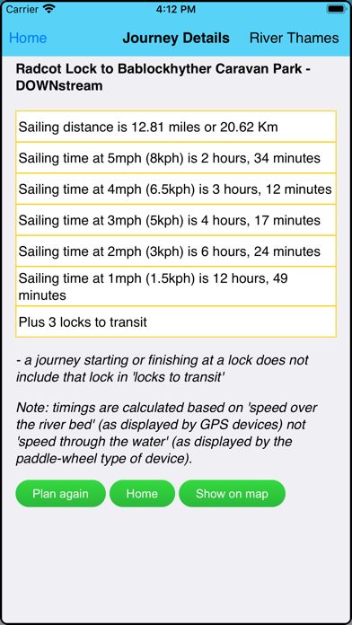
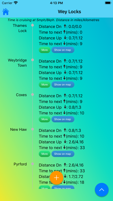
JOURNEY PLANNER: select a starting point and destination from the supplied list of 102 landmarks (including locks, marinas, moorings, bridges and places of interest (from Lechlade to the Thames Barrier) and immediately see the sailing distance, direction (up or downstream), sailing time (at 5 mph, 3 mph and 1 mph) and the number of locks to transit to complete your journey; Wey navigation planner features 45 locations.

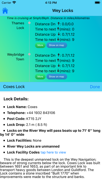
LOCK FEATURES: every Thames lock is listed in order from Cricklade Bridge to Teddington with distance to next lock both up and downstream. Touch any lock to see much more information including: telephone number; post code; lock type; width, drop and length; lock keeper’s hours; facilities available (such as WC, water, pump out etc). From the lock detail just tap to highlight this lock in the middle of the interactive map. Portage Maps for Sonning to Teddington locks.

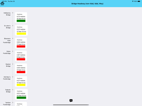
BRIDGE HEADWAY: every bridge listed in order with headway in feet and metres; bridge headways are colour coded for ease of use and instant check to see if you need to lower any masts.

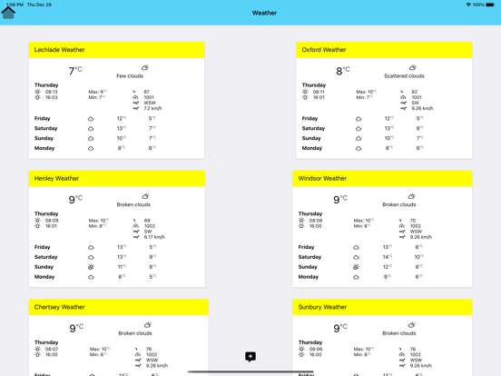
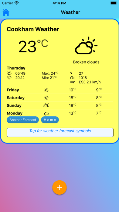
WEATHER*: select one of 20 location on the river for an up-to-date weather forecast for today and tomorrow (includes temperature, winds, humidity, visibility, sunrise and sunset). Requires an Internet connection. The weather page includes the current nautical twilight (the correct time to strike your ensign).

CURRENT RIVER CONDITIONS*: for safer river use always verify the current official conditions before setting off; non-tidal conditions are provided by the Environment Agency (the River Thames authority) and categorised as Red, Yellow or Green – tap to view an explanation of the colours. Tidal conditions are provided by the Port of London Authority. Includes current and planned river closures and river restrictions.

IN CASE OF EMERGENCY: River Thames Guide includes an SOS section with information, endorsed by the RNLI, on how to deal with various problems including: Man Overboard; Boat Sinking; Boat on Fire; Boat Drifting. NOTE: these sections should be studied before embarking so that you can react properly to any emergency. Better still: take an appropriate course before using the river.

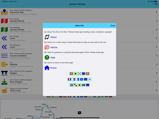
HELP: every page contains tips on using River Thames Guide to help plan your journey, find somewhere to eat or stay, using the map, and more.

* requires an active Internet connection
Show More

What's New in the Latest Version 24.3

Last updated on Mar 7, 2024
Old Versions
Conditions' Widgets
Three stretch widget
One stretch widget (for tidal and non-tidal)
all for iPhone, iPad, Mac

New Home Screen layout
optimised to suit user's screen size
Upgrade to back end
to improve app resilience
Improvements for small screens
information on non-tidal and Wey Navigation issues
now summarised rather than opening long agency page
Show More
Version History
24.3
Mar 7, 2024
Conditions' Widgets
Three stretch widget
One stretch widget (for tidal and non-tidal)
all for iPhone, iPad, Mac

New Home Screen layout
optimised to suit user's screen size
Upgrade to back end
to improve app resilience
Improvements for small screens
information on non-tidal and Wey Navigation issues
now summarised rather than opening long agency page
23.6
Jun 3, 2023
Updated map engine (improved user response)
Conditions display restored
for non-Tidal improved
in river order with conditions colour coded
(without all the extraneous stuff on the EA conditions web page!)
Conditions overlayed on map
each section (lock to lock) on non-tidal
overlayed with live condition colour
23.4
Apr 25, 2023
Updated backend
underlying framework updated
for improved look and feel
and more responsive to user input
Conditions display
for non-Tidal improved
Minor GUI improvements
23.1
Feb 17, 2023
New Maps
new map tiles used for easier reading
RTG Lite only offers much greater magnification when viewing the map
Easier to use map overlay selection
the side panel to select overlays for the interactive map
now expands on smaller screens (to make selections easier)
Easier to use right panel overlays
the left side panel now expands on smaller screens (to make selections easier)
MISSING update - the planned update to show live river conditions on the interactive map has been withheld after the Environment Agency decided (without notice or consultation) to withdraw the RSS service used by the app.
22.5
May 15, 2022
Improved 'Hone' link for smaller screens
Added 'Home' link in popup.
22.04
May 6, 2022
A big maintenance update
new, improved map engine
better stability, faster response to user input and more
AND developed in Ukraine, so happy to support...
Popups on maps clearer
changed the font for easier reading on smaller screens
EA Mooring conditions updated
to reflect latest rules
added summary of those rules (in Advice section)
Updated most icons
to improve readability
larger, cleaner, better colours
22.03
Mar 2, 2022
2022 lockkeepers' hours for all locks on Thames.
New icons for easier readability.
Behind the scenes improvements for performance and stability.
Facilities updated for selected marinas.
Improved Wey Navigation conditions.
21.8
Aug 15, 2021
Mainly a maintenance update
new, improved back end
better stability, faster response to user input and more
Navigation improvements
making it easier to select options
Changed Ensign striking calculation
now using Sunset as recommended by RYA
20.8
Aug 9, 2021
Mainly a maintenance update
new, improved back end
better stability, faster response to user input and more
Navigation improvements
making it easier to select options
Changed Ensign striking calculation
now using Sunset as recommended by RYA
21.3
Mar 17, 2021
Link to Thames Widgets - real time river conditions for your selected stretches on Today screen (iPad) or any screen (iPhone).
Plus some minor tweaks behind the scenes.
20.92
Sep 11, 2020
Remembered to include the changes promised in the previous version (20.91)!
20.91
Sep 10, 2020
- Updated the map engine
- removed the rain radar viewer due to incompatibility with new engine (will restore when working again)
20.81
Aug 19, 2020
Added new map overlay for electric charging points
highlighting locks, marinas etc with electric charging
(check non-locks for availability before mooring!)
Added new map option for rain radar
tap 'cloud' icon at top left of map
to see rain radar overlaid on interactive map
use the buttons to see rain progress
or press Play/Stop to see last two hours of radar coverage
Updated lock keepers hours to new 2020 schedule (Thames Locks/Help)
20.72
Jul 25, 2020
Actually provide the updated version! The 'update' to version 20.71 was the same as 20.51. Apologies for the error, this should now provide the new functionality...
20.71
Jul 22, 2020
Improvements to the weather page
easier to use on smaller screens
Time to strike your Ensign moved to home page
Improved navigation on PLA Advice for smaller screens

Under the hood improvements
for better performance
and more stability
20.52
May 31, 2020
Fixed an issue preventing the app from updating or downloading...
20.51
May 23, 2020
Fixed an issue where some popups were partly hidden on smaller screens.
Upder the hood improvements to stability and performance.
20.4
Apr 29, 2020
Removal of large pictures at the bottom of most screens; rarely seen on mobile devices; removing them does not change the app functionality but saves space!
Improved options when no internet available
Under the hood improvements for better performance and greater stability.
20.3
Mar 4, 2020
Fixed an issue where current river conditions did not display correctly on some devices
20.2
Feb 6, 2020
Non-tidal River Thames current conditions, closures and restrictions in a more mobile-friendly format
Wey Navigation current conditions, closures and restrictions in a more mobile-friendly format
Under the hood improvements for better performance and greater stability.
19.99.12
Dec 19, 2019
On the Home page a new Tips option
Tap 'Tips' in the right hand menu bar
and see a selection of popups to help you get the best from River Thames Guide
All telephone numbers now 'hot' links
just tap to call from your smartphone
Updated marina map overlay (again!)
with more boat hire options
with loads of pubs on the Wey Navigation
Optimised images
to reduce size of app
and improve performance
Added some safety advice graphics from PLA
available on the Advice page
Info on how to get river conditions without an Internet connection
no longer needs an Internet connection!!
19.99.11
Nov 7, 2019
Update to underlying framework
to make app more responsive
and preparation for some new features later
Navbar scrolls off page to reveal more screen
Better layout for iPhones with 'notch'
app data no longer sometimes obscured by 'notch'
Tweak to appearance of weather page
and added countdown timer to Strike Ensign popup
Updated marina map overlay
19.99.10
Oct 4, 2019
Compatibility with iOS 13 Dark Mode - note: to ensure that both Dark adn Light modes work well, some icons and background images have been changed. Functionality is unchanged.
19.9
Sep 24, 2019
Thames Journey Planner - show your route on map
plan your journey
and show the route highlighted on the interactive map
Added simple, accurate ‘Find me’ for Emergency Services or friends
use simple one-click to find the three words describing your location to within three metres
Emergency Services can use the three words to pinpoint your exact location
email friends or colleagues with link to show your location to within three metres
instructions and link on Advice page
Fixed an issue with Locks page popups
facilities and lock keepers’ hours did not always popup
Trivial change to the grammar in Planner results
19.81
Aug 13, 2019
Thames Journey Planner display improvements
rather than always show 104 locations:
choose which river sections to show (one or more)
use Settings to select your default sections to open
Thames Journey Planner improved accuracy
all distances re-measured to higher accuracy
measurements to/from locks to middle of lock
measurements to/from marinas to mid-channel opposite entrance
Thames Journey Planner new locations
added Bray Marina and Windsor Marina
Tidal locations revised to marinas/piers where available (rather than bridges)
improvement to Lock info popups
on smaller screens, lock info partly obscured by navigation buttons
all info now fully visible on all screen sizes
Preparation for iOS 13
Home page looks nicer with some new icons

River Thames Guide Lite FAQ

Click here to learn how to download River Thames Guide Lite in restricted country or region.
Check the following list to see the minimum requirements of River Thames Guide Lite.
iPhone
Requires iOS 11.0 or later.
iPad
Requires iPadOS 11.0 or later.
iPod touch
Requires iOS 11.0 or later.
River Thames Guide Lite supports English

River Thames Guide Lite Alternative

You May Also Like

Get more from Jeff Maynard