Spyglass ist ein wesentliches GPS-Toolkit für draußen und Offroad-Navigation. Vollgepackt mit Tools, dient es als Fernglas, Frontscheibenanzeige, Hightech-Kompass mit Karten, Kreiselkompass, GPS-Empfänger, Wegpunkt-Tracker, Tacho, Höhenmesser, Sonne-, Mond-und Sterne-Finder, künstlicher Horizont, Entfernungsmesser, Koordinaten-Konverter, Sextant, Neigungsmesser, Winkelrechner und Kamera. Es speichert Ihre benutzerdefinierten Standorte und Wegpunkte, navigiert später genau zu ihnen hin, zeigt sie unter Verwendung von Augmented-Reality auf Karten an, zeigt detaillierte GPS-Infos, misst Distanzen, Größen, Winkel und kann noch viel mehr.
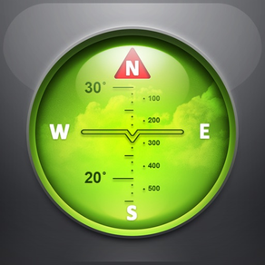
KOMPASS & KREISELKOMPASS
Die in Spyglass enthaltenen Techniken zur Verbesserung der Genauigkeit, spezielle Kompass-Modi und Kalibrierungsmethoden, machen es zu einem echten Instrument und modernsten, präzisesten digitalen Kompass.
FINDER, TRACKER & AR NAVIGATION
Spyglass funktioniert dreidimensional und verwendet Augmented Reality, um Objektpositionen, Informationen und Wegbeschreibungen zu ihnen als Überlagerung von Kamerabild und Karten anzuzeigen.
Speichern Sie aktuelle Positionen, fügen Sie Punkte aus Karten hinzu, geben Sie Koordinaten und Standort-Funkpeilungen manuell ein, fügen Sie Sterne manuell hinzu oder verwenden Sie einen integrierten Sternkatalog.
Finden Sie gespeicherte Orte und Objekte später einfach, indem Sie Richtungspfeilen folgen.
Spyglass verfolgt mehrere Ziele gleichzeitig und zeigt Informationen dazu an: Entfernung, Richtung, Abweichung, Elevation und Ankunftszeit.
Unter Verwendung vieler unterstützter Formate können Sie Standorte, Koordinaten und Kartenlinks kopieren, einfügen und teilen.
GPS, TACHO & HÖHENMESSER
Finden und verfolgen Sie Ihre Position und erhalten Sie detaillierte Echtzeit-GPS-Daten – Koordinaten in Dutzenden von Formaten, Höhe, Kurs, aktuelle, maximale und vertikale Geschwindigkeit unter Verwendung britischer, metrischer, nautischer Maß- und Vermessungseinheiten.
KARTEN
Sehen Sie sich Ihre Position und die Zielposition mithilfe verschiedener Kartenstile und alternativer Kartenanbieter an – planen Sie Wegpunkte und messen Sie Entfernungen.
VERFOLGEN VON STERNEN, SONNE UND MOND & NAVIGIEREN NACH STERNEN
Verfolgen Sie die Positionen von Sternen, Sonne und Mond mit der Präzision von Bogensekunden – Verwenden Sie sie als Referenz, um den Kompass für maximale Genauigkeit zu kalibrieren.
OPTISCHER ENTFERNUNGSMESSER
Messen Sie Entfernungen zu Objekten in Echtzeit, ähnlich wie beim Visier von Scharfschützen, mit einem Messsucher-Fadenkreuz.
SEXTANT, WINKELRECHNER UND WINKELMESSER
Finden Sie die Höhe von Objekten und die Entfernung zu ihnen heraus – nehmen Sie visuelle Messungen vor und berechnen Sie Abmessungen und Entfernungen.
KAMERA
Machen Sie mit allen verfügbaren positionellen und direktionalen GPS-Daten überlagerte Aufnahmen.
DEMO & HILFE
Videos:
http://j.mp/spyglass_vids
Handbücher:
http://j.mp/spyglass_help