Spyglass

Spyglass


GPS, compass and maps toolkit


6,99 €

3.17for iPhone, iPad and more
9.5
760 Ratings
Pavel Ahafonau
Developer
55,2 Mo
Size
Dec 7, 2022
Update Date
#26
in Navigation
4+
Age Rating
Age Rating
4+
Apps in this category do not contain restricted content.
9+
Apps in this category may contain mild or occasional cartoon, fantasy or real-life violence, as well as occasional or mild adult, sexually suggestive or horrifying content and may not be suitable for children under 9 years of age.
12+
Apps in this category may contain occasional mild indecent language, frequent or intense cartoon or real-life violence, minor or occasional adult or sexually suggestive material, and simulated gambling, and may be for children under 12 years of age.
17+
You must be at least 17 years old to access this App.
Apps in this category may contain frequent and intense offensive language; Frequent and intense cartoon, fantasy or realistic violence: frequent and intense adult, scary and sexually suggestive subjects: as well as sexual content, nudity, tobacco, alcohol and drugs, may not be suitable for children under 17 years of age.
Spyglass Captures d'écran
Spyglass AfficheSpyglass AfficheSpyglass AfficheSpyglass AfficheSpyglass AfficheSpyglass AfficheSpyglass AfficheSpyglass Affiche

About Spyglass

Spyglass, boîte à outils GPS de navigation en plein air et tout terrain pour s'en servir comme de jumelles, viseur haute-technologie, boussole high-tech avec carte, compas gyroscopique, récepteur GPS, traceur de balisage, compteur de vitesse, altimètre, cadran solaire, détecteur de la lune et des étoiles, gyroscope d’horizon, télémètre, convertisseur de données, sextant, inclinomètre, calculatrice d’angle et appareil photo. Elle sauvegarde vos lieux et vos points habituels, navigue précieusement vers eux ultérieurement, les montre sur des cartes grâce à la réalité augmentée en temps-réel, affiche des informations GPS détaillées, mesure des distances, des dimensions, des angles et plus encore.

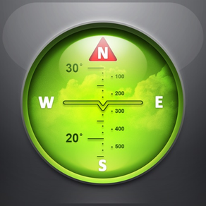
BOUSSOLE ET COMPAS GYROSCOPIQUE

Les techniques d’amélioration de la précision, les modes boussole spéciaux et les méthodes d’étalonnage disponibles dans Spyglass en font un véritable instrument unique – la boussole numérique la plus avancée et la plus précise.

EXPLORATEUR, TRACEUR ET NAVIGATEUR

Spyglass fonctionne en 3D et utilise la réalité augmentée pour montrer la position des objets en temps réel, les informations et les distances superposé sur un appareil photo ou des cartes.

Sauvegardez la position actuelle, ajoutez des points à partir des cartes, saisissez manuellement les coordonnées des emplacements et des releveurs, ajoutez des étoiles à la main ou utilisez un catalogue d’étoiles intégré.

Trouvez des lieux et des objets ultérieurement en suivant simplement les flèches directionnelles.

Spyglass suit plusieurs cibles en simultané et affiche leurs informations – distance, direction, azimuts, altitude et heure d’arrivée estimée.

Copiez, collez et partagez les emplacements, les coordonnées et les liens de carte pris en charge sous de nombreux formats.

GPS, COMPTEUR DE VITESSE ET ALTIMÈTRE

Découvrez et suivez votre position puis obtenez en temps réel des données GPS détaillées – coordonnées en dizaines des formats, d’altitude, de cap, de vitesse actuelle, maximale et verticale en utilisant des unités impériales, métriques, nautiques et unités de prospection.

CARTES

Consultez vos positions et les positions cibles sur les cartes grâce à des styles de cartes différents et de fournisseurs alternatifs - planifiez des repères et mesurez des distances.

SUIVI DES ÉTOILES, DU SOLEIL ET DE LA LUNE ET NAVIGATION SOUS LES ÉTOILES

Suivez la position des étoiles, du soleil et de la lune grâce à une précision en arc de seconde – utilisez-les comme référence pour calibrer la boussole et une précision maximale.

TÉLÉMÈTRE OPTIQUE

Mesurez les distances aux objets en temps réel grâce à un réticule télémétrique à l’identique d’un tireur d’élite.

SEXTANT, CALCULETTE D’ANGLE ET INCLINOMÈTRE

Découvrez l’altitude des objets et les distances jusqu’à eux - mesurez visuellement et calculez les dimensions et les distances.

APPAREIL PHOTO

Prenez des photos superposées grâce aux données directionnelles et de position GPS.

DÉMONSTRATION ET AIDE

Vidéos:
http://j.mp/spyglass_vids

Manuels:
http://j.mp/spyglass_help
Show More

Quoi de neuf dans la dernière version 3.17

Last updated on Dec 7, 2022
Vieilles Versions
- Improved color themes:
· visual color editor in settings
· change compass north arrow color
· change buttons and shadows colors
· color, black, and white text stroke or blur
· colorized black and white (light) maps
· separate blue and cyan themes
· improved auto-invert for incompatible colors (black on black)
- Fixed EXIF import/export bug for negative latitude/longitude
- Compatibility improvements and bug fixes
Show More
Version History
3.17
Dec 7, 2022
- Improved color themes:
· visual color editor in settings
· change compass north arrow color
· change buttons and shadows colors
· color, black, and white text stroke or blur
· colorized black and white (light) maps
· separate blue and cyan themes
· improved auto-invert for incompatible colors (black on black)
- Fixed EXIF import/export bug for negative latitude/longitude
- Compatibility improvements and bug fixes
3.15
Oct 14, 2022
- Search offline for places, mountains, lakes, parks, airports, etc.
- Nearest most notable places, mountains, castles, landmarks in search
- Track nearest airport (y-shape mark on the inner compass circle)
- Set altitude manually in the "* > location" top left corner
- Configure action for new targets (track only, center map, set as current)
- Do not track previous targets as secondary unless explicitly set to
- Sub-millimeter precision for location coordinates editing
- Sub-millimeter precision D.x coordinate format in settings
- Compatibility improvements and bug fixes
3.11.1
May 15, 2022
Fixed a bug preventing saving camera shots
3.11
Apr 2, 2022
Minor fixes
3.10.11
Mar 29, 2022
Improved iOS 15 support
Import GPS coordinates from image EXIF data
Simplified sharing functionality
3.10.9
Oct 5, 2021
We’ve made some tweaks and improvements to make your experience even smoother
3.10.7
Sep 1, 2021
HD Thunderforest maps
UI improvements
3.10.5
Aug 8, 2021
- Added two new info tools accessible via the satellite button at the lower left of the main screen:
1) Satellites - a celestial map showing computed positions of major GPS/GNSS satellites in the sky above you
2) Dashboard - all sensor data presented in a convenient large number display
- Bug fixes
- Under the hood improvements preparing the app for future updates
3.10.3
Jun 22, 2021
HD Thunderforest maps
UI improvements
3.10.1
May 25, 2021
New Thunderforest Maps
UI fixes
Navigation improvements
Easier map selection
3.10
May 23, 2021
New Thunderforest Maps
UI fixes
Navigation improvements
Easier map selection
3.9.17
Mar 21, 2021
New onboarding screen
UI improvements
Rotation fixes
Automatic coordinates lookup is now configurable
3.9.15
Dec 8, 2020
- Added the haptic feedback for compass
- Added a precise location check to avoid positioning issues
- UI improvements
- Improved localizations
- Improved coordinates processing for Southern Hemisphere
- iOS 14.2 enhanced support
3.9.13
Jun 24, 2020
- Night mode color themes for maps
- Bug fixes
3.9.12
May 30, 2020
v.3.9.12:
- Fixed a bug preventing a keyboard input
- Updated Google Earth link sharing format
v.3.9.11:
- Improved layout and font sizes for the main screen
- Support for latest iOS versions and new devices
- Lots of minor bug fixes
3.9.11
May 28, 2020
- Improved layout and font sizes for the main screen
- Support for latest iOS versions and new devices
- Lots of minor bug fixes
3.9.9
Dec 22, 2017
○ better display of vertical speed on ascent/descent
○ performance and stability improvements
3.9.7
Dec 18, 2017
○ performance and stability improvements
3.9.5
Nov 2, 2017
○ improved compatibility with iPhone X, iPhone 8, iPhone 8 Plus
○ added Sigma Octantis (σ Octantis, south pole star) into built-in star catalog
○ stability and performance improvements
3.9.3
Sep 7, 2017
○ improved coordinate parser
3.9
Aug 17, 2017
○ offline OSM maps optimized for high-resolution displays
· download the entire low-res world map for high zoom levels
· download selected map regions for all zoom levels
○ improved recognition of coordinates
· recognition of non-standard minute (′) and second (″) symbols
· recognition of Geo Caching coordinates with a minute sign omitted
○ stability and compatibility improvements

In the app settings, you can now select a retina-optimized map source “OSM @ Happymagenta”. Once you select it the “Download” button will become active. Then you will be able to download maps for offline use.

Improved recognition of coordinate input allows you now to copy and paste, or type in coordinates in a more convenient way. Non-standard symbols that can be used to indicate minutes and seconds of a degree will now be properly interpreted.

Additionally, you can now copy and paste, or type in coordinates with minute and second symbols omitted when the degree symbol is present:

N 37° 41.501 W 97° 20.282 will be recognized as N 37° 41.501' W 97° 20.282'

N 37° 41 30.06 W 97° 20 16.92 will be recognized as N 37° 41' 30.06" W 97° 20' 16.92"
3.7.11
Oct 7, 2015
· compatible with latest iOS and new devices
· sub-meter GPS accuracy
· improved detection of coordinates in copied text
· improved resolution of taken photos and screenshots
· lots of smaller improvements and bug fixes

Sub-meter, sub-foot, sub-yard, 5-digit accuracy kilometers and miles are now available as short distance units in the app settings. Smaller units are now only used for short distances while higher precision kilometers and miles are also used for long distances. Send us your thoughts if you have an external sub-meter GPS and want this feature improved further.

If you've noticed a bug or have some troubles with setting up the app, please contact us via the support form on our web site.
3.7.9
May 19, 2015
v.3.7.9 improves UI orientation on iPad in landscape mode
v.3.7.5 improves compatibility with iOS 8 and new devices (read full details):
- better compatibility with iOS 8 and iPhone 6, iPhone 6 Plus
- 64-bit support and major code cleanup in preparation for bigger updates
- lots of improvements and bug fixes, including:
· smoother transition between 3D and 2D compass operation modes
· improved gyrocompass mode (see details below)
· gyrocompass adjustment retained in background on devices w/o compass
· runtime automatic camera field of view detection for precise AR mapping
· better camera support for all new devices (iPhone 6, 6 Plus, iPad Air 2)
· improved camera access settings handling
· improved location access settings handling
· improved detection of long tap on the main screen
· improved user interface orientation handling
· landscape face up orientation support
· improved editing, text input and keyboard handling
· support of hiding of keyboard by sliding
· full support of native screen resolutions of new devices
· new icons optimized for new iOS and new devices
· fixed inverted sign of magnetic declination display
· fixed crash-alike behavior when app was closed and then shortly opened
· fixed crash that might happen because of lots of waypoints on a map
· fixed parsing of GEO: links with uppercase scheme part
· fixed hemisphere sign for longitudes on text format export

IMPROVED GYROCOMPASS MODE

The gyrocompass mode can now be used as a primary mode. Now in the gyrocompass mode the magnetic sensor is referenced continuously until a manual adjustment to the heading is made using the two finger sliding gesture. Unless the manual adjustment is in effect the app acts as a gyro-assisted magnetic compass.

If you've noticed a bug or have some troubles with setting up the app, please contact us via support form on our website.
3.7.7
Jan 23, 2015
v.3.7.7 fixes GPS issue on iOS prior to 8
v.3.7.5 improves compatibility with iOS 8 and new devices (read full details):
- better compatibility with iOS 8 and iPhone 6, iPhone 6 Plus
- 64-bit support and major code cleanup in preparation for bigger updates
- lots of improvements and bug fixes, including:
· smoother transition between 3D and 2D compass operation modes
· improved gyrocompass mode (see details below)
· gyrocompass adjustment retained in background on devices w/o compass
· runtime automatic camera field of view detection for precise AR mapping
· better camera support for all new devices (iPhone 6, 6 Plus, iPad Air 2)
· improved camera access settings handling
· improved location access settings handling
· improved detection of long tap on the main screen
· improved user interface orientation handling
· landscape face up orientation support
· improved editing, text input and keyboard handling
· support of hiding of keyboard by sliding
· full support of native screen resolutions of new devices
· new icons optimized for new iOS and new devices
· fixed inverted sign of magnetic declination display
· fixed crash-alike behavior when app was closed and then shortly opened
· fixed crash that might happen because of lots of waypoints on a map
· fixed parsing of GEO: links with uppercase scheme part
· fixed hemisphere sign for longitudes on text format export

IMPROVED GYROCOMPASS MODE

The gyrocompass mode can now be used as a primary mode. Now in the gyrocompass mode the magnetic sensor is referenced continuously until a manual adjustment to the heading is made using the two finger sliding gesture. Unless the manual adjustment is in effect the app acts as a gyro-assisted magnetic compass.

If you've noticed a bug or have some troubles with setting up the app, please contact us via support form on our website.
3.7.5
Jan 21, 2015
- better compatibility with iOS 8 and iPhone 6, iPhone 6 Plus
- 64-bit support and major code cleanup in preparation for bigger updates
- lots of improvements and bug fixes, including:
· smoother transition between 3D and 2D compass operation modes
· improved gyrocompass mode (see details below)
· gyrocompass adjustment retained in background on devices w/o compass
· runtime automatic camera field of view detection for precice AR mapping
· better camera support for all new devices (iPhone 6, 6 Plus, iPad Air 2)
· improved camera access settings handling
· improved location access settings handling
· improved detection of long tap on the main screen
· improved user interface orientation handling
· landscape face up orientation support
· improved editing, text input and keyboard handling
· support of hiding of keyboard by sliding
· full support of native screen resolutions of new devices
· new icons optimized for new iOS and new devices
· fixed inverted sign of magnetic declination display
· fixed crash-alike behavior when app was closed and then shortly opened
· fixed crash that might happen because of lots of waypoints on a map
· fixed parsing of GEO: links with uppercase scheme part
· fixed hemisphere sign for longitudes on text format export

IMPROVED GYROCOMPASS MODE

The gyrocompass mode can now be used as a primary mode. Now in the gyrocompass mode the magnetic sensor is referenced continuously until a manual adjustment to the heading is made using the two finger sliding gesture. Unless the manual adjustment is in effect the app acts as a gyro-assisted magnetic compass.

If you've noticed a bug or have some troubles with setting up the app, please contact us via support form on our website.

If you find Spyglass useful, please help us spread the word by leaving a review in the App Store. In case you've reviewed a previous version of Spyglass please resubmit it as ratings reset with each new update. It's very important as it allows us to continually improve the experience and helps other users decide whether the app is right for them. Thanks a lot for your support!

Spyglass FAQ

Cliquez ici pour savoir comment télécharger Spyglass dans un pays ou une région restreints.
Consultez la liste suivante pour voir les exigences minimales de Spyglass.
iPhone
Nécessite iOS 13.0 ou version ultérieure.
iPad
Nécessite iPadOS 13.0 ou version ultérieure.
iPod touch
Nécessite iOS 13.0 ou version ultérieure.
Spyglass prend en charge Français, Allemand, Anglais, Chinois simplifié, Espagnol, Italien, Japonais, Néerlandais, Polonais, Portugais, Russe, Turc
Spyglass contient des achats intégrés. Veuillez vérifier le plan tarifaire ci-dessous:
Spyglass Plus
3,49 €

Alternative à Spyglass

Tu pourrais aussi aimer

Obtenir plus de Pavel Ahafonau