1) Increased resolution of the ECMWF model along with the addition of new data from this model, including CAPE, wind shear, precipitation type, and dew point.
2) Bug fixes
1) A few weeks ago, we added a worldwide tide forecast. We are now introducing tide forecasts in line charts, where you can combine them with wave or weather data for any location on Earth.
2) You can now access a 10-day wave forecast from the MFWAM model, computed by Météo-France.
3) Bug fixes.
1) New 7-Day Tide Map Forecast - under the 'Sea' menu, we have added a comprehensive worldwide tide forecast. It leverages the state-of-the-art American STOFS model, providing high-resolution and highly accurate tide data globally.
2) New 7-Day Tide and Surge Map Forecast - monitor the impact of storms and tropical cyclones on sea levels. This feature is designed to keep you informed and safe from rising sea levels.
3) New 7-Day Tidal Currents Map Forecast
4) Improved Webcam Viewer: Enhanced with a new play feature for a smoother viewing experience
5) Bug Fixes
Exciting update! Our widget collection has expanded with some great additions. Now, you can effortlessly access webcams and delve into detailed weather forecasts right from your home screen. Plus, we're thrilled to introduce our new lock screen widgets, bringing essential information to your fingertips even faster.
The update incorporates enhancements to various indicators, reflecting the valuable feedback we have received from you.
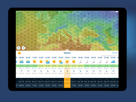
1) Included pressure data in both hourly and daily graphs
2) Provided wave information in hourly graphs
3) Added wind direction information to hourly graphs
4) Bug fixes and minor improvements
The update incorporates enhancements to various indicators, reflecting the valuable feedback we have received from you.
1) Included pressure data in both hourly and daily graphs
2) Provided wave information in hourly graphs
3) Added wind direction information to hourly graphs
4) Bug fixes and minor improvements
1) We are now displaying the cloud base. This way, you can easily see at what height the cloud cover starts.
2) Bug fixes
1) New button for quick return to current location
2) Location search improvements
3) Bug fixes
Explore our new hourly weather charts, combining temperature, rainfall, wind, snow or precipitation probability charts together with our cutting-edge visualization tool. These charts provide a clear and visual guide to meteorological data, offering a unique perspective on its interconnectedness.
1) Weather charts (hourly on 14 days)
2) Higher zoom with more details in maps
3) Bug fixes
We're thrilled to announce a minor but meaningful update to our app's interface. With subtle changes, we've enhanced experience, making things clearer and design nicer.
1) New graphical interface
2) Bug fixes and minor improvements
We're thrilled to announce a minor but meaningful update to our app's interface. With subtle changes, we've enhanced experience, making things clearer and design nicer.
1) New graphical interface
2) Bug fixes and minor improvements
A major update is here. Ventusky can now send notifications with extensive customization options.
- Notifications with weather forecasts, precipitation probabilities, wind or lightning alerts
- Increased resolution of European radar
- Option to set 12 or 24 hour time format
- Bug fixes and minor improvements
Webcam map - you can display the positions of more than 20 000 webcams around the world directly on the map
Improved display of cities on maps
Bug fixes
New map tiles for the highest zoom (in retina resolution).
Improved display of cities on maps
Bug fixes
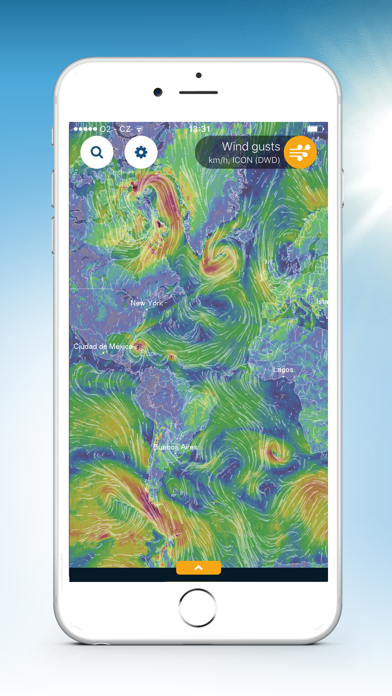
Radar now includes real-time lightning detection. You can easily see where the lightning has struck. The lightning detection coverage is worldwide with the greatest accuracy in North America and Europe.
- Great news for all sailors and fishermen in Northern Europe. We have just added a very high resolution (4km) wave model called WAVEWATCH (NO) covering Scandinavia and the surrounding area. This model is important for overall security on the sea. This model is provided to us by Norwegian Meteorological Institute (MET.no).
- Bug fixes and small improvements
- We have added a new high resolution model MEPS for Scandinavia and Northern Europe. It is crucial in this very rough terrain with fjords to follow high resolution model. Model has resolution 2.5 km and it is updated every 3 hours. This model is provided to us by Norwegian Meteorological Institute (MET.no).
- Bug fixes
- New option for Automatic model configuration. Now you can choose what models do you prefer and should be used for the forecast map. You no longer have to constantly switch between models, but you can use the configuration that suits you best.
- More weather layers from high resolution UKMO-UK model (model covers United Kingdom)
- Displaying snow and lightning strikes on the radar layer. Current lightning strikes are updated every 10 minutes including prediction. Snow information is determined based on the model predictions.
- Significantly improved location list. Location name can be edited. You can view a summary forecast for all locations in the list page.
- Bug fixes
- Webcams (for selected locations, not yet available as a map layer). We process images from up to 20 000 webcams around the world, offering one of the largest camera networks on the Internet. Especially in mountainous areas, you can monitor real conditions (fog, snow, etc.). Wide coverage is enabled by cooperation with partners such as Panomax.com, Feratel, NOAA or Foto-webcam.eu. Enjoy the view.
- Bug fixes