iMariner Offshore

iMariner Offshore


$13.99

4.1for iPhone, iPad and more
1.9
1 Ratings
DFR Editions
Developer
310.1 MB
Size
Jul 21, 2021
Update Date
Navigation
Category
4+
Age Rating
Age Rating
4+
Apps in this category do not contain restricted content.
9+
Apps in this category may contain mild or occasional cartoon, fantasy or real-life violence, as well as occasional or mild adult, sexually suggestive or horrifying content and may not be suitable for children under 9 years of age.
12+
Apps in this category may contain occasional mild indecent language, frequent or intense cartoon or real-life violence, minor or occasional adult or sexually suggestive material, and simulated gambling, and may be for children under 12 years of age.
17+
You must be at least 17 years old to access this App.
Apps in this category may contain frequent and intense offensive language; Frequent and intense cartoon, fantasy or realistic violence: frequent and intense adult, scary and sexually suggestive subjects: as well as sexual content, nudity, tobacco, alcohol and drugs, may not be suitable for children under 17 years of age.
iMariner Offshore Screenshots
iMariner Offshore posteriMariner Offshore posteriMariner Offshore posteriMariner Offshore poster

About iMariner Offshore

Prepare your navigation and your landings : includes GSHHS shore lines, major lighthouses, GPS, AIS, magnetic variation, position of Sun and Moon, logbook.
Note : AIS display requires an AIS/Wifi gateway
-------
AIS : AtoN, MOB, ships
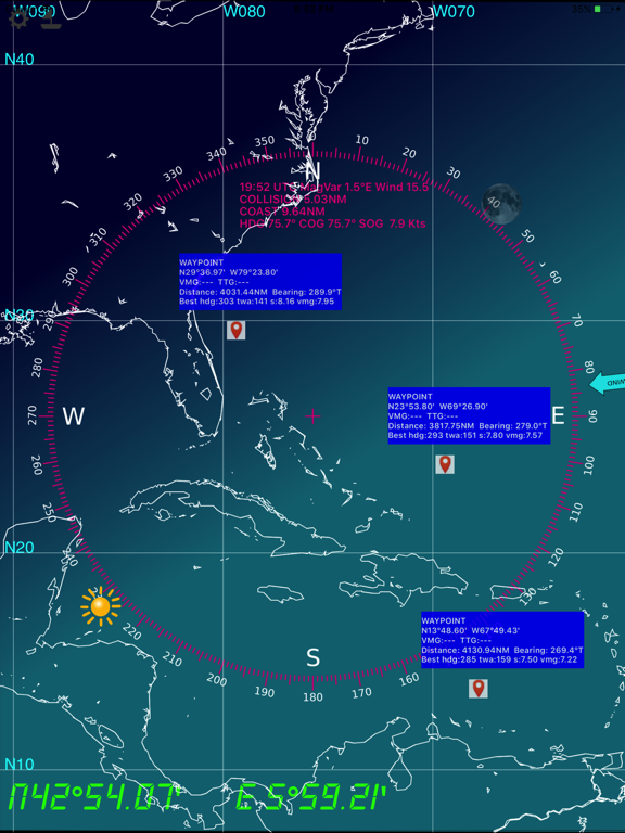
-------
WayPoints
-------
Also embedded are the USCG database and NGA database of all marine lights around the world, that have a nominal range of 10 or more Nautical Miles.
IMPORTANTE NOTICE : Mariners should consult all sources of information they have before engaging their vessel to an unkwnow area, in particular notices to mariners.
NOTICE : NGA and USCG lights databases have been extracted in Feb 2013. This application will be updated in a regular basis.
-------
All major ligthhouses (landing) that have a distance at least 15 NM for the following countries :
Full world coverage.
--------
- based on the NOAA's GSHHS Shoreline Database Version 2.2.0
- world coverage from 75°S to 75°N (poles excluded)
- zoom in and zoom out : automatically selects between the 5 GSHHS databases : full, high, intermediate, low, crude
- mercator projection
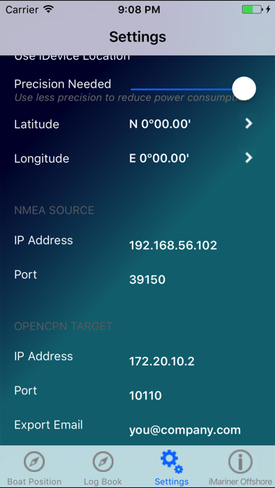
- Precise positioning of your boat and other vessels (NMEA GPS and AIS frames)
- you need a NMEA Wifi connection (TCP or UDP) with a NMEA repeater like Digital Yacht's iAIS
- log book (date,time,latitude,longitude,COG,SOG,Heading,Log,Water Depth,
TWA,TWS,Leeway,Stream Set, Stream Drift and your comments
- log book organized in passages
- log book export via email (csv format)
- NMEA protocol debug window
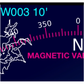
- magnetic variation computed with the algorithms from the NOAA's World Magnetic Model
- distance to coast
- distance to others vessels
- 'goto boat' function
- double tap for full screen display
- integrated solar compass : the rose displays the sun and moon positions in real time
Show More

What's New in the Latest Version 4.1

Last updated on Jul 21, 2021
Old Versions
- fix some display issues when in landscape
- SOG much more visible
- Text in white
- Don't display wind if info is not available
- Udp broadcast support (without ip address)
Show More
Version History
4.1
Jul 21, 2021
- fix some display issues when in landscape
- SOG much more visible
- Text in white
- Don't display wind if info is not available
- Udp broadcast support (without ip address)
4.0
Jun 12, 2021
Rework for new AppStore standards.
3.4
Oct 2, 2017
Corrects an issue with GPS notifications in iOS11
Tested with Vesper Marine XB-8000
Tested with ShipModule Miniplex-3
3.3
Feb 21, 2017
Compatibility with VesperMarine XB-8000 AIS/Wifi gateway
Output $--RMB messages to an autopilot
3.2
May 13, 2016
- double finger press to display AIS targets information
- single finger press to add/remove WP
- AIS age
- MOB, EPIRB, SART
- Wind speed
- WP, bearing, distance, VMG, TTG
- AtoN (AIS type 21)
3.1
Dec 15, 2015
64-bits version for iOS9
3.0
Sep 11, 2014
* Rotate the WIND image as an indicator of the wind angle (unless this information is retreived by NMEA).
* A line indicates the true heading
* A line indicates the COG
* A scale indicates where your ship will be in 1,2,3,4 and 5 hours
1.5
Dec 12, 2013
Complete world coverage of major nautical lights (all areas).
iOS7 and iOS6.1 support
1.4
Nov 5, 2013
Fixes display issues with ios7 and iPhone 5.
Adds COG and SOG.
1.3
Feb 14, 2013
NGA and USCG lights worldwide database for lights >= 10NM
1.2
Jan 25, 2013
All major ligthhouses (landing) that have a distance at least 15 NM for the following countries :
US east coasts (thanks to NOAA S-57 data) and Cuba,
France Atlantic and Mediteranean coast, Corse, Portugal includiong Gibraltar, North Atlantic Islands (Acores, Canarias, Madera),
Caraibans, Panama (Atlantic and Pacific Coasts), Colombia to French Guiana
South Pacific Islands (thanks to msi.nga.mil-List of Lights)
Work is in progress for a world coverage : updates are of course free for you !

iOS5 and iOS6 compatible
1.1
Jun 8, 2012
We have fixed this issue in the iPad display.
We have rewrite the code handling the Passages. This version is in testing phase.
Added export in KML format, for displaying your passages in Google Earth.
Added internal GPS accuracy (Settings).
1.0
Apr 29, 2012

iMariner Offshore FAQ

Click here to learn how to download iMariner Offshore in restricted country or region.
Check the following list to see the minimum requirements of iMariner Offshore.
iPhone
Requires iOS 9.0 or later.
iPad
Requires iPadOS 9.0 or later.
iPod touch
Requires iOS 9.0 or later.
iMariner Offshore supports English

iMariner Offshore Alternative

You May Also Like

Get more from DFR Editions