ArcGIS Responder 10.9
無料
21.1.2for iPhone, iPod touch
Age Rating
ArcGIS Responder 10.9 スクリーンショット
About ArcGIS Responder 10.9
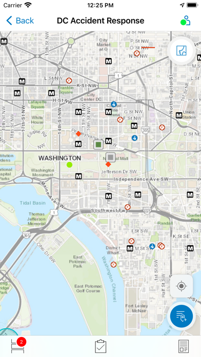
ArcGIS Mission Responder is the mobile app that enables users in the field to participate in active missions as part of Esri’s ArcGIS Mission product.
ArcGIS Mission is a focused, tactical situational awareness solution that is fully integrated with Esri’s market leading ArcGIS Enterprise product. ArcGIS Mission allows organizations to create, share, and operate in missions using integrated maps, teams, and other mission related materials like photographs, documents, map products, and other information types. ArcGIS Mission is designed to provide organizations with a real-time view of their common operating picture and provides remote, mobile users with situational understanding to be able to answer the question, “What’s going on around me right now?”.
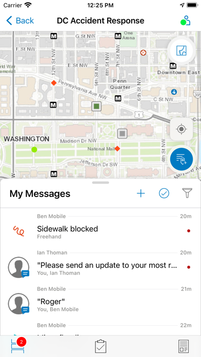
As the mobile component of ArcGIS Mission, Responder is the mobile app that enables operators to maintain communications and collaboration with their teammates as well as others in support of, and participating in, the mission through real time messaging and reporting.
Key Features:
- Secure, protected connection to ArcGIS Enterprise
- View and participate in active missions of ArcGIS Enterprise
- View, interact and explore mission maps, layers and other resources
- Send instant messages to other users, teams and all mission participants
- Receive, view, and respond to user-specific tasks
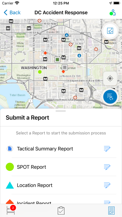
- Use an optimized report form to create and view reports from the field
- Create simple map sketches to communicate and collaborate with other mission participants
- Attach photos and other file based resources for sharing as GeoMessages
Note: Continued use of GPS running in the background can dramatically decrease battery life.
Show More
最新バージョン 21.1.2 の更新情報
Last updated on 2021年11月17日
旧バージョン
-Updated for compatibility with iOS 15
-New naming convention
-New app icon
-New splash screen
-New naming convention
-New app icon
-New splash screen
Show More
Version History
21.1.2
2021年11月17日
-Updated for compatibility with iOS 15
-New naming convention
-New app icon
-New splash screen
-New naming convention
-New app icon
-New splash screen
21.1.1
2021年05月24日
- Expanded and enhanced capabilities for offline work, including store-and-forward for all major workflows
- Support for map popups and layers
- Support for secure and authenticated environments
- Use of customized reports, created by managers for specific missions
- Version compatibility check
- Support for map popups and layers
- Support for secure and authenticated environments
- Use of customized reports, created by managers for specific missions
- Version compatibility check
21.1.0
2021年05月06日
- Expanded and enhanced capabilities for offline work, including store-and-forward for all major workflows
- Support for map popups and layers
- Support for secure and authenticated environments
- Use of customized reports, created by managers for specific missions
- Support for map popups and layers
- Support for secure and authenticated environments
- Use of customized reports, created by managers for specific missions
20.3.0
2020年09月29日
- New User Interface
The bottom navigation bar now only has three tools, as the Start New Chat tool has been moved onto the My Messages panel.
- Unread Indicator
The Unread Indicator now has expanded functionality, including numbering and a Mark All As Read button.
The bottom navigation bar now only has three tools, as the Start New Chat tool has been moved onto the My Messages panel.
- Unread Indicator
The Unread Indicator now has expanded functionality, including numbering and a Mark All As Read button.
20.2.0 (6)
2020年07月28日
ArcGIS Responder 10.9 FAQ
ここをクリック!地理的に制限されているアプリのダウンロード方法をご参考ください。
次のリストをチェックして、ArcGIS Responder 10.9の最低システム要件をご確認ください。
iPhone
iOS 12.0以降が必要です。
iPod touch
iOS 12.0以降が必要です。
ArcGIS Responder 10.9は次の言語がサポートされています。 日本語, アラビア語, イタリア語, インドネシア語, ウクライナ語, オランダ語, カタロニア語, ギリシャ語, クロアチア語, スウェーデン語, スペイン語, スロバキア語, タイ語, チェコ語, デンマーク語, トルコ語, ドイツ語, ノルウェー語 (ブークモール), ハンガリー語, フィンランド語, フランス語, ヘブライ, ベトナム語, ポルトガル語, ポーランド語, ルーマニア語, ロシア語, 簡体字中国語, 繁体字中国語, 英語, 韓国語


