Strat Mobile

Strat Mobile


Stratigraphy on your phone


Free

2.2.0for iPhone, iPad and more
1.9
1 Ratings
Richard Allmendinger
Developer
8.8 MB
Size
Nov 13, 2019
Update Date
Education
Category
4+
Age Rating
Age Rating
4+
Apps in this category do not contain restricted content.
9+
Apps in this category may contain mild or occasional cartoon, fantasy or real-life violence, as well as occasional or mild adult, sexually suggestive or horrifying content and may not be suitable for children under 9 years of age.
12+
Apps in this category may contain occasional mild indecent language, frequent or intense cartoon or real-life violence, minor or occasional adult or sexually suggestive material, and simulated gambling, and may be for children under 12 years of age.
17+
You must be at least 17 years old to access this App.
Apps in this category may contain frequent and intense offensive language; Frequent and intense cartoon, fantasy or realistic violence: frequent and intense adult, scary and sexually suggestive subjects: as well as sexual content, nudity, tobacco, alcohol and drugs, may not be suitable for children under 17 years of age.
Strat Mobile Screenshots
Strat Mobile posterStrat Mobile posterStrat Mobile poster
Strat Mobile posterStrat Mobile posterStrat Mobile posterStrat Mobile posterStrat Mobile poster

About Strat Mobile

Strat Mobile is a program for iOS devices that enables you to measure and record stratigraphic sections right on your iPhone or iPad. Some of the basic tasks that one can perform with the app include:

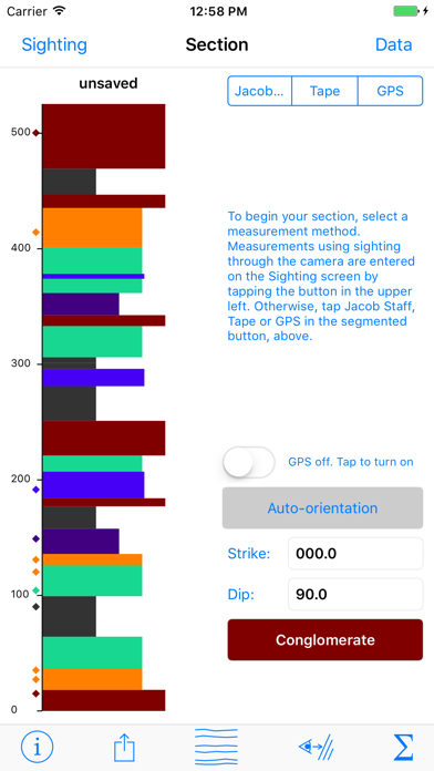
• Real time plotting of the stratigraphic section as it is being measured.

• Measure sections using your know eye height as the “Jacob Staff” by sighting down dip through the device camera. The thickness of the measured interval, of course, depends directly on the dip (as well as your eye height).

• Measure sections using a traditional Jacob Staff. The device can determine the strike and dip of the bedding for you with the tap of a button

• Measure sections using a tape measure. You enter the tape azimuth, slope, start and end point, as well as the strike and dip of bedding, and the device will calculate the correct thickness automatically.

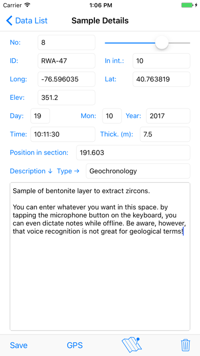
• Automatically record, latitude, longitude, time and date for every interval measured

• You can define an unlimited number of lithology types (with corresponding colors and widths) to draw your section and tag your observations

• Provide basic statistics on the section measured, including the thicknesses and percentages of each lithology

• See the locations of entire sections, measured intervals, and samples on a satellite image or road map.

• Provide basic input and output of data using standard iOS conventions

Will work on iPhones or iPads. The program will work on iPads lacking a cellular data connection but those devices have fewer sensors and thus cannot be used in automatic data collection mode.
Show More

What's New in the Latest Version 2.2.0

Last updated on Nov 13, 2019
Old Versions
v. 2.2.0 -- 13 November 2019

This new version brings enhanced iOS 13 compatibility as well as a few important bug fixes. The iOS 13 sharing panel will no longer freeze the app, maps have been improved, and a bug in the GPS thickness calculation routine that would trigger under certain conditions has been fixed. Also, this version can now import Strat Desktop data on the clipboard, which was broken in recent versions, and you can now add formation names to your data. Though there is no significant new functionality in this version, you should definitely update if you are using recent versions of iOS on your device.
Show More
Version History
2.2.0
Nov 13, 2019
v. 2.2.0 -- 13 November 2019

This new version brings enhanced iOS 13 compatibility as well as a few important bug fixes. The iOS 13 sharing panel will no longer freeze the app, maps have been improved, and a bug in the GPS thickness calculation routine that would trigger under certain conditions has been fixed. Also, this version can now import Strat Desktop data on the clipboard, which was broken in recent versions, and you can now add formation names to your data. Though there is no significant new functionality in this version, you should definitely update if you are using recent versions of iOS on your device.
2.0.1
Apr 30, 2018
v. 2.0.1 — 2018.04.29

• Bug fix for case of incorrectly formatted clipboard text when importing lithology types.

v. 2.0.0 — 2018.04.16
• A new view allows you to enter the grain size at the base and top of a unit and select a description of the basal contact (e.g., erosional, gradational, etc.). Specifying a different top and base grain size will cause the right hand boundary of the unit in the column to be drawn on a diagonal to reflect fining or coarsening upwards. Clastics use a different classification than carbonates. You access this view from the "More" button in the upper right corner of the Interval Details screen.

• Use a two fingered pinch gesture to shrink or expand the scale of the column shown on the section page. Once shrunk or expanded, you can use a one fingered drag in the column to scroll to the part that you want to see. Double tapping a unit will still take you to the interval details view. To return to the default view with the entire column on the screen, simply go to any other view and then return to the section view.

• Incorporation of macrostrat.org lithology types, groups and names as well as official colors. To access these terms, tap the strat column icon on the bottom of the section view and then tap the new button to bring up the lithology definition screen. You will see three spinner controls. In the top two side by side controls, you can select the macrostrat type and group designations and in the bottom one select the lithology name. Alternatively, you can just start typing the lithology name and Strat Mobile will select any matching entries in the macrostrat listing. The color bar sliders are selected automatically to yield the color for the lithology type defined in the macrostrat database, although you can override those after setting the lithology. Any existing lithologies that you have defined will be searched for to see if they match the macrostrat sedimentary rock type listing and will assign the type and group characteristics, but will not override your color selection. Note that you can define the lithologies that you want and save them as default lithologies for a new section. You may also want to define a lithology type called "gap" or some such thing and assigned a white color for covered intervals.

• You can now use the system clipboard to import lithology definitions to suit your project or desktop software by clicking the the Import Clipboard button in the lithology type view (reached by tapping the column icon on the Section view). Thus you can store different sets of lithology definitions for different projects or classes in, say, Notepad and then copy and paste them into Strat Mobile as needed. Pasting new lithologies in does not replace any lithologies that already have intervals assigned to them, nor will it duplicate any existing lithology types, but it will erase any unused lithology types. Lithology definitions may be exported from the same view using the new "Share" button at the bottom of the screen.

• This version of Strat Mobile has a new output file format to accommodate the new data functionality. It will read your old data files but any file saved with this version will not be readable by older versions of the program. The name of the section is now included in the first line of the data file and is automatically displayed when restored from the RecoveryFile. Strat Desktop, available at http://www.geo.cornell.edu/geology/faculty/RWA/programs/strat-desktop.html has been updated for compatibility.

• New organization, much faster operation, and more stable, less memory intensive design of the Data List View, espcially with there are a large number of intervals/samples.

• Moved the Section Name text field to the top of the screen so it will not be covered by the keyboard.

• The GPS is off reminder message in the Section.Jacob staff view can be dismissed permanently for the session by tapping the "Stop Prompting Me" button the first time it appears.
2.0.0
Apr 17, 2018
v. 2.0.0 — 2018.04.16

• A new view allows you to enter the grain size at the base and top of a unit and select a description of the basal contact (e.g., erosional, gradational, etc.). Specifying a different top and base grain size will cause the right hand boundary of the unit in the column to be drawn on a diagonal to reflect fining or coarsening upwards. Clastics use a different classification than carbonates. You access this view from the "More" button in the upper right corner of the Interval Details screen.

• Use a two fingered pinch gesture to shrink or expand the scale of the column shown on the section page. Once shrunk or expanded, you can use a one fingered drag in the column to scroll to the part that you want to see. Double tapping a unit will still take you to the interval details view. To return to the default view with the entire column on the screen, simply go to any other view and then return to the section view.

• Incorporation of macrostrat.org lithology types, groups and names as well as official colors. To access these terms, tap the strat column icon on the bottom of the section view and then tap the new button to bring up the lithology definition screen. You will see three spinner controls. In the top two side by side controls, you can select the macrostrat type and group designations and in the bottom one select the lithology name. Alternatively, you can just start typing the lithology name and Strat Mobile will select any matching entries in the macrostrat listing. The color bar sliders are selected automatically to yield the color for the lithology type defined in the macrostrat database, although you can override those after setting the lithology. Any existing lithologies that you have defined will be searched for to see if they match the macrostrat sedimentary rock type listing and will assign the type and group characteristics, but will not override your color selection. Note that you can define the lithologies that you want and save them as default lithologies for a new section. You may also want to define a lithology type called "gap" or some such thing and assigned a white color for covered intervals.

• You can now use the system clipboard to import lithology definitions to suit your project or desktop software by clicking the the Import Clipboard button in the lithology type view (reached by tapping the column icon on the Section view). Thus you can store different sets of lithology definitions for different projects or classes in, say, Notepad and then copy and paste them into Strat Mobile as needed. Pasting new lithologies in does not replace any lithologies that already have intervals assigned to them, nor will it duplicate any existing lithology types, but it will erase any unused lithology types. Lithology definitions may be exported from the same view using the new "Share" button at the bottom of the screen.

• This version of Strat Mobile has a new output file format to accommodate the new data functionality. It will read your old data files but any file saved with this version will not be readable by older versions of the program. The name of the section is now included in the first line of the data file and is automatically displayed when restored from the RecoveryFile. Strat Desktop, available at http://www.geo.cornell.edu/geology/faculty/RWA/programs/strat-desktop.html has been updated for compatibility.

• New organization, much faster operation, and more stable, less memory intensive design of the Data List View, espcially with there are a large number of intervals/samples.

• Moved the Section Name text field to the top of the screen so it will not be covered by the keyboard.

• The GPS is off reminder message in the Section.Jacob staff view can be dismissed permanently for the session by tapping the "Stop Prompting Me" button the first time it appears.

• Fixed a bug related to samples when appending one file to another as well as other bug fixes.
1.0.2
Mar 22, 2018
v. 1.0.1/1.0.2 - 21 March 2018

• (v. 1.0.2 fixes a crashing bug entering samples while making a tape measurement that was introduced in v. 1.0.1)

• Shares the same file format with the new desktop companion app at http://www.geo.cornell.edu/geology/faculty/RWA/programs/strat-desktop.html

• The trash can icon on the Data List view is now called "New" because you typically use this button to clear the app of old measurements so you can enter a new section.

• Minor change to the data file format to work around an issue when mailing data whereby the mail program would strip out consecutive tab characters. Blank columns are now indicated by an underscore character. Old data files should continue to work just fine.

• Fixed a bug where changing units would not change the units on the samples. This should now work just fine.
1.0.1
Mar 20, 2018
v. 1.0.1 - 19 March 2018

• Shares the same file format with the new desktop companion app at http://www.geo.cornell.edu/geology/faculty/RWA/programs/strat-desktop.html

• The trash can icon on the Data List view is now called "New" because you typically use this button to clear the app of old measurements so you can enter a new section.

• Minor change to the data file format to work around an issue when mailing data whereby the mail program would strip out consecutive tab characters. Blank columns are now indicated by an underscore character. Old data files should continue to work just fine.

• Fixed a bug where changing units would not change the units on the samples. This should now work just fine.
1.0
Dec 20, 2017

Strat Mobile FAQ

Click here to learn how to download Strat Mobile in restricted country or region.
Check the following list to see the minimum requirements of Strat Mobile.
iPhone
Requires iOS 10.0 or later.
iPad
Requires iPadOS 10.0 or later.
iPod touch
Requires iOS 10.0 or later.
Strat Mobile supports English

Strat Mobile Alternative

You May Also Like

Get more from Richard Allmendinger