ArcGIS Earth

ArcGIS Earth


免費

2.0for iPhone, iPad and more
ESRI
Developer
102.4 MB
Size
2023年12月14日
Update Date
Productivity
Category
Age Rating
4+
Apps in this category do not contain restricted content.
9+
Apps in this category may contain mild or occasional cartoon, fantasy or real-life violence, as well as occasional or mild adult, sexually suggestive or horrifying content and may not be suitable for children under 9 years of age.
12+
Apps in this category may contain occasional mild indecent language, frequent or intense cartoon or real-life violence, minor or occasional adult or sexually suggestive material, and simulated gambling, and may be for children under 12 years of age.
17+
You must be at least 17 years old to access this App.
Apps in this category may contain frequent and intense offensive language; Frequent and intense cartoon, fantasy or realistic violence: frequent and intense adult, scary and sexually suggestive subjects: as well as sexual content, nudity, tobacco, alcohol and drugs, may not be suitable for children under 17 years of age.
ArcGIS Earth 螢幕截圖
ArcGIS Earth 海報ArcGIS Earth 海報ArcGIS Earth 海報ArcGIS Earth 海報ArcGIS Earth 海報ArcGIS Earth 海報ArcGIS Earth 海報ArcGIS Earth 海報

About ArcGIS Earth

ArcGIS Earth is designed for everyone and provides user-friendly 3D experiences.

Data support
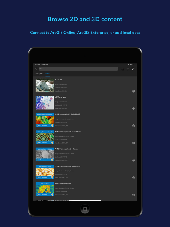
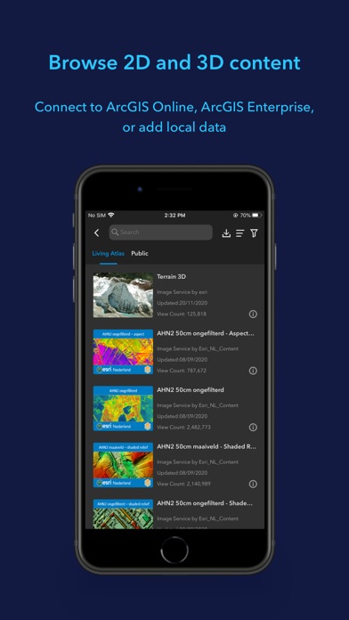
ArcGIS Earth allows you to use a variety of items from ArcGIS Online, ArcGIS Enterprise, local data, and web services:
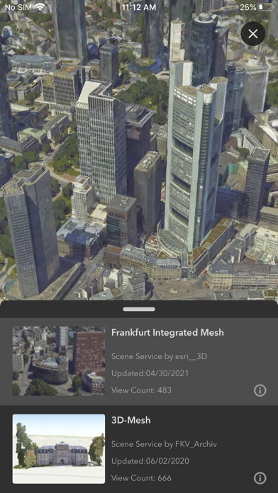
• Browse web scenes, map services, image services, scene services, and feature services.
• Browse local files including mobile scene packages (MSPK), KML, KMZ, tile packages, and scene layer packages (SLPK).
• Support has been added for Living Atlas of the World.

Key features
• Connect to ArcGIS Online or ArcGIS Enterprise.
• Tap to identify features.
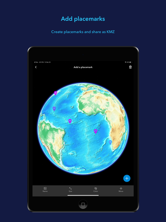
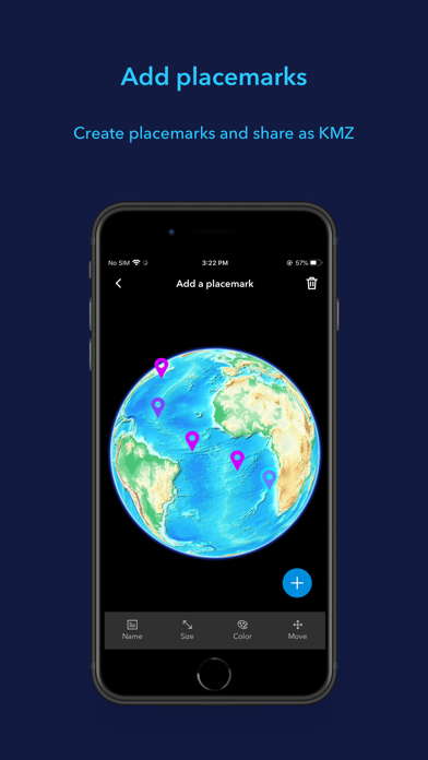
• Support has been added for collecting, editing, and sharing placemarks.
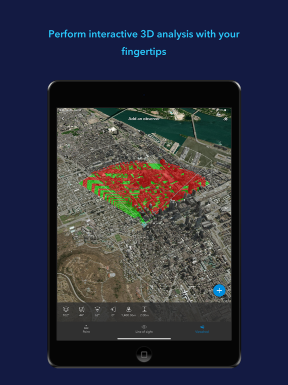
• Interactive analysis tools include Measure, Line of Sight, and Viewshed.
• Create and share tours with geotagged photos.
• Search for places and switch locators.
• Start-up tips and guidance for hand gestures are included.
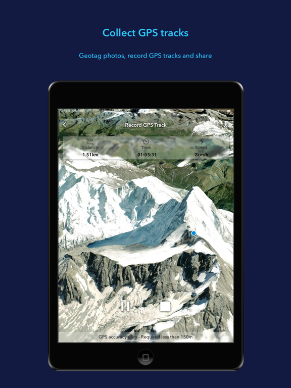
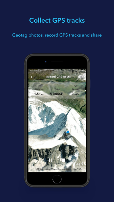
• Record and preview GPS tracks, and share with your organization.
Show More

最新版本2.0更新日誌

Last updated on 2023年12月14日
歷史版本
• Support for viewing underground data and setting ground transparency
• Support for drawing points, lines, and polygons, and sharing as a .kmz file. Drawings will be saved and managed in the Table of Contents Drawings tab
• Enhanced the tour experience. You can add placemarks (points) and geotagged pictures to the tour, customize views, and add text to waypoints
• Improved the geosearch experience and supported viewing and copying the result coordinates
Show More
Version History
2.0
2023年12月14日
• Support for viewing underground data and setting ground transparency
• Support for drawing points, lines, and polygons, and sharing as a .kmz file. Drawings will be saved and managed in the Table of Contents Drawings tab
• Enhanced the tour experience. You can add placemarks (points) and geotagged pictures to the tour, customize views, and add text to waypoints
• Improved the geosearch experience and supported viewing and copying the result coordinates
1.7.2
2023年04月29日
Fixed some bugs.
1.7.1
2023年01月18日
Fixed some bugs
1.7
2022年11月22日
1.7
- Support for adding web maps to a 3D scene
- Support for the location unit setting in UTM and MGRS
- Support for recording and sharing video in AR mode
1.6
2022年07月08日
- Support for measuring distance and area on the ground surface
- Support for measuring direct, vertical, and horizontal distances between two points in 3D scene
- Ability to view temporal data changing over time and control the time animation
1.5.1
2022年04月21日
Fixed some bugs
1.5
2022年03月03日
- Support for vector tile layer data type.
- Display data on a flat surface in the AR mode
- View details of Track statistics including speed and elevation profiles.
- Support for recording and visualizing GPS Tracks in 3D with z-value.
1.4.2
2021年10月29日
• Fixed some bugs
1.4.1
2021年09月24日
- Fixed an issue in displaying pictures in KML pop-up contents.
- Fixed a bug that the app prompts for an additional certificate when adding data from a PKI signed-in portal in iOS.
1.4
2021年08月19日
Version 1.4
• GPS—Add styled symbols in displaying GPS tracks, provide two angles for viewing, and support generating a card for easier sharing.
• Add data—Remember the search history, simplify the add data process, and enable adding to My Favorites.
• Recommend data for users.
• Search a place by coordinates.
• Record a tour in landscape mode.
• Support has been added for uploading all placemarks to a user's account.
• Fixed some bugs.
1.3.2
2021年06月17日
Fixed some bugs
1.3.1
2021年04月14日
- Support MDM with App Managed Config
- Improved the layout of my contents in left panel menu
- Supported displaying the points in GPS tracks with direction properties
- Optimized the UI and workflow of “Download MSPK from portal item”
- Improved the UX of viewshed analysis tool editor
- Fixed the bug for PKI Portal connection
1.3
2021年01月08日
V1.3

Features
• Users now can easily record their tracks from GPS location of a mobile device, and export the result as a KMZ file or upload to their organization's portal.
• With a native screenshot tool, taking and sharing a snapshot of the screen and data in full screen can be easily achieved.
• ArcGIS Earth for mobile now supports routing to a searched place or a predefined placemark via navigation apps.
• Connecting to Portal is made easier by simply scanning a QR code of the URL, saving time and effort.
• The default Terrain can be switched off from the Basemap list when needed.

Enhancements
• Enhanced layer management by supporting the deletion of multiple layers.
• Improved the layout of Add Data.
• Supported to display layer full name by long pressing the layer in Table of Contents.
• Improved support for connecting to Enterprise Portal using PKI.
V1.2
2020年09月01日
- Well adapted iPad (vertical screen mode)
- Provided a default basemap “Imagery” to Basemap List, if not signed into ArcGIS Online or ArcGIS Enterprise
- Enhanced 2D Maps and 3D Scenes rendering in iOS with Apple's Metal framework
- Fixed some bugs
V1.1.1
2020年04月30日
- Supported to download mobile scene package data from Portal, and added a new page “My Downloads” to monitor the download status
- Supported to generate QR Code and save to Album for Image service, Map service, Scene service, Feature service
- Supported to filter portal content by “Item Type”, ”Date Modified” and “Status”
V1.1
2020年01月16日
Add data from the QR code generated from ArcGIS Earth for desktop. Supported data types are as follows:
- ArcGIS services
- Portal items
- Web scenes


Adapted the icon size to iOS 13

Enhanced the zoom to algorithm

When sharing My Placemarks, if the account is not set up, ArcGIS Earth supports to open and configure the Mail App
1.0.1
2019年11月29日
New Features in v1.0.1 release
- Support for adding portal items with Enter a URL.
- More options to open and share local data with ArcGIS Earth on mobile. You can share data via AirDrop, download and add data from browsers, email attachments or instant message apps such as Messenger.
- Support and adapt to iOS 13.
- Support for signing in to a portal with SAML authentication of version 10.7 and later.
- Numerous enhancements and bug fixing.
1.0.0
2019年09月17日

ArcGIS Earth FAQ

點擊此處瞭解如何在受限國家或地區下載ArcGIS Earth。
以下為ArcGIS Earth的最低配置要求。
iPhone
須使用 iOS 15.0 或以上版本。
iPad
須使用 iPadOS 15.0 或以上版本。
iPod touch
須使用 iOS 15.0 或以上版本。
ArcGIS Earth支持俄文, 德文, 日文, 法文, 波蘭文, 英文, 西班牙文

ArcGIS Earth相關應用

你可能還喜歡

ESRI 開發者的更多應用