Fixes a very rare crash when setting/editing tags.
- There's a new widget for the Homescreen available which shows the steps of the currently active step counter as bar chart
- Fixes an issue where the recording view on the iPhone did not update itself when the recording was started/stopped remotely on the Apple Watch.
- Fixes the duration that was shown on the Apple Watch in the alternative recording view.
- Fixes an issue where the main menu on the iPad did not show up when it was hidden
- Fixes an issue where displaying the speed/altitude charts for long long-term tracks was too slow.
- When defining a geo-based action to start a recording it is now possible to directly define the track color for the tracks which are created by this action.
- The Tracks view has now an option to animate the travel route of the track on the Map and the chart. The "play/stop" button can be found in the charts view for the track and when tapped will show an animation of the whole travel route on the Map (a Pin which moves on the track based on the recorded speed) and the information window on the chart will show the details as well. Long-pressing the play/stop button lets you play the animation in different speeds.
- When importing GPX or KML files the new release will now show a list of all tracks, routes and places that are found in these files (if there're more than one), so you can select only those items you actually want to import.
- The Watch App has now alternative Dashboards for the recording view as well (simply tap into the dashboard to toggle between the two options)
- The App provides a larger collection of unique colors for the charts to avoid reusing existing colors when a larger number of data values have to be displayed.
- Bugfix: When using the "remote control" feature on the watch for the step counter running on the iPhone, stopping the step counter did actually work, but did not show the new status on the watch.
- Bugfix: Importing GPX tracks from other Apps via ShareSheet did not work if the App was terminated before from within the task switcher
- Bugfix: The charts for the Timetracking feature could crash in case the time/duration unit settings were configured to the extra long time option.
- Bugfix: Pasting a UUID value into the text field when defining a Bluetooth beacon did not work
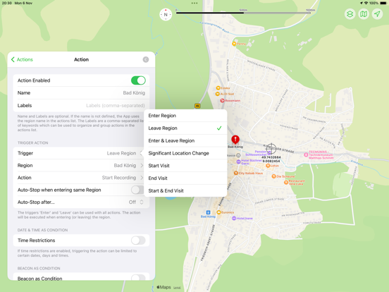
Bugfix: When defining time/date restrictions for location-based action the configuring the allowed start and end time did not work.
- The filter function for saved tracks has been optimized and no longer blocks when filtering locations (when there are thousands of tracks). Filtering by location can still take longer if there are thousands of tracks, but now runs in the background
- The filter function can now also filter by date and time
- When restoring data, the backup function now only offers data that can actually be found in the backup.
- There is a new setting to display the status of the step counter and track recording in the navigation bar of the main menu (so the status remains visible even when the menu is minimized).
- You can now also assign tags to saved tracks, which can then be used to group the tracks list.
- It is now easier to specify the tags (tracks & actions) via a selection list
- The input dialog for numerical values now has a "Undo" button with which you can undo changes again
- There is a new option in the navigation bar: the button at the top right can not only switch between two sizes when tapped, but can now also be long-pressed and then opens a menu that can be used to switch between several sizes. On the iPad, the entire view on the left-hand side can also be completely hidden in order to see the map in full screen.
- The Watch App now also has an alternative dashboard layout; you can switch between the two layouts with a single tap.
- On the Apple Watch, entries in the steps and tracks list that have not yet been synchronized to the iPhone are now marked with a dot.
- Bugfix: Under certain circumstances, the calculation of the duration of breaks did not work
- Bugfix: On the Apple Watch, the view was not updated immediately when manually transferring the data to the iPhone.
- Bugfix: Loading saved locations could fail if the locations date back to iOS 5/6 and have never been changed and no locations have been added or deleted since then
- Fixes a few issues which potentially could result in a crash under very special circumstances
- It turns out that HealthKit has issues with tracks (exported to HealthKit) if these have "gaps" of more than 5 seconds (for example in areas with bad or no GPS reception, like in tunnels, buildings etc). In this case HealthKit simply doesn't save the track or at least the Fitness App doesn't show them. The new Pado release will now fill these gaps with "dummy" data to work around this issue.
- New WebHook feature: Time Tracking (check-in/check-out) and Track Recording (start/stop) can be now also reported to the WebHook server. For time tracking this can be enabled individually for each time tracking entry. For track recordings you can enable this is the settings. If enabled Pado will send information about the current region or location to the webhook server whenever the status changes. There will be a new "source" parameter sent to the webhook server which can be used to find out from which source the information is coming, possible values are "action", "recording", "longtermrecording" and "timetracking". For time tracking the enter/exit parameters will be used to tell the server whether Pado has entered or exited the region. For recordings the parameters "start" and "stop" are used to indicate wether the recording was started or stopped.
There were a few issues in the new App version which are addressed with this update:
- Bugfix: Importing GPX files could fail
- When importing GPX files without speed information, Pado will now calculate the speed information itself
- Bugfix: Opening the Stepcounter could freeze the App in case the Stepcounter is still running and was running for an extremely long time (years). The new release will show the progress in a chart and putting years of data in one chart is actually far more than the iOS charts framework can handle. So the step counter will now limit the data that is shown in the chart.
- Bugfix: When using the WebHook feature to be notified about significant location changes, not all of the data that was sent before was sent with the new version.
- There's a new switch for the WebHook feature where you can decide wether the message information is only sent to the webhook server or also posted as local notification to be notified on the phone about these webhook actions.
- When sharing coordinates (tap or long-press on coordinates) will now also provide options to explicitly share these to Apple, Google and Bing Maps.
GENERAL INFO
Pado will soon be 10 years old and therefore has a long history. So it was time to put Pado on a new, modern technical footing. Version 3 of Pado has therefore been reprogrammed and redesigned from scratch. All the old familiar features have of course been retained, but are now technically up to date and modernized. I hope you like the result. I look forward to any feedback, comments, suggestions for improvement and also bug reports are welcome.
NEW FEATURES
- The new user interface can be customized in the settings
- The map view now also supports the "look around" feature
- In the new version, the map is now always visible in the background, the menu can be freely positioned above the map on the iPhone. At any time you can now decide how large the proportion of the map and the other app functions should be.
- NFC tags (including Apple's AirTags) can now also be used as triggers for location-based actions.
- Access to the app's stored data can now be secured via FaceID/TouchID.
- Tracks can now also be exported to the Health app
- New interactive widgets (for iOS 17) allow you to control the app (track recording, pedometer, time tracking) from the home screen or lock screen without having to start the app
- Extended support for Live Activities/Dynamic Island shows data from an active pedometer, an active track recording and time tracking via the Lock Screen or Dynamic Island.
- Many other major and minor enhancements in most areas of the app
- The built-in help should describe all the features.
PAYMENT MODEL
With Pado 3, the payment model has changed. The previously paid app is now offered free of charge and can therefore be fully tested without any payments. There are now three app levels:
- Free:
A maximum of 3 locations, 3 actions and 3 entries for time tracking can be created
- Standard (one-time purchase):
A maximum of 25 locations, 25 actions and 25 entries for time tracking can be created.
- Pro (one-time purchase):
Any number of locations, actions and entries for time tracking can be created.
Everything else is available in all three levels without restrictions
Users who have already purchased earlier versions of the app will automatically receive the Standard level free of charge. If restrictions have already been reached, existing actions/locations are not restricted, i.e. the app remains fully usable. By purchasing the update, however, you can upgrade to the Pro version at a reasonable price.
New users can now react more flexibly to their own needs and use one of the three options as required. An inexpensive update from the Standard to the Pro version is also available at any time, in case you need more than you initially thought.
There is still no subscription and no ongoing payments. But there is now also a tipping option for all those who value the app more than the small one-time payments and want to do something good for the developer.
- There's a new trigger for geo-based actions available which can trigger the action whenever the device has significantly changed its location. This trigger is not based on a certain region, it always triggers when the device has moved significantly. The iOS itself defines what is considered as a "significant location change" (which is approx 500 m, max every 5 min) and can do this with almost no impact to the battery life. This trigger is most useful if you want to track your movement permanently and use the Web-Hook feature to store all the data.
- There're new geo-based actions which can be used to start or stop long-term recordings.
- For all actions which are defined to start a track recording, there's an option to automatically stop the recording again after a certain time or when the region where the recording has started was reached again. Using this option you often don't need to explicitly define another action to stop the recording again. Even though a second action to stop the recording can be much more flexible, because a dedicated action for stopping the recording can also stop manually started recordings or recordings started by other actions.
- There're now new export options. It is possible to export tracks with a reduced data set as "Routes". These "route" export options don't keep all coordinates of a track (approx. 1 coordinate per second), instead only the minimum amount of coordinates are kept, which are necessary to reproduce the path (for example when traveling a straight section of a street, only 1 coordinate at the beginning and one at the and of this section will be kept, within curves some more coordinates are kept). The export of Routes can be done as CSV and as GPX file.
- There's a new option for Web-Hook which can repeat sending data to the Web-Hook server whenever this has failed. Please note, the App only tries for about 5 days to send the data and only for temporary errors (for example if there's no internet connection, or the server is down/unreachable).
- There are some new commands available for controlling the App via „pado“ URL (pado://cmd). The following commands (cmd) are available: startRecording, stopRecording, startLongTermRecording, stopLongTermRecording, startStepCounter, stopStepCounter, stepCounter, Tracks, Actions, timeTracking, monitoredRegions, allRegions
- There's a new red color scheme available (in light and dark).
- Bugfix: On the iPad the option "Vibrate" for the actions is no longer available (because the iPad can't vibrate)
- Bugfix: The calendar view is now evaluating the first day of the week option from the system settings and sorts the weekdays accordingly.
- Bugfix: When selecting music within the "actions" the OK/Cancel buttons where not always visible.
- Bugfix: When selecting a region within the actions, the currently selected region will be now automatically shown on the map and the list of regions.
- Fixes an issue when transmitting recorded tracks from the Apple Watch to the iPhone again (they were transmitted already before) could override changes made on the iPhone for these tracks.
- When running on a Mac the App could crash because the Apple-provided way to check for the availability of "live activities" doesn't work on a Mac. This version includes a check for a Mac (Apple silicon), so when running on a Mac it doesn't check if Live Activities are available anymore.
- Solves a few minor issues
In iOS 16.1 the App supports "Live Activities" on the iPhone.
When a track recording is started within the App and you leave the App, you can now find information about the ongoing recording (current speed, distance, compass, etc) in the dynamic island (iPhone 14 Pro) and on the lockscreen (all iPhones).
iOS 16 has an issue when displaying custom maps (raster tiles). These maps are drawn above the track overlay layer instead of below this layer (as this was the case in previous iOS releases), therefore the tracks were no longer visible when using the OpenTopoMap or other custom maps (added via Tile server). This update solves the issue.
- Under iOS 16 it is no longer possible for an App to get the user-defined name of the device from the system settings. Pado uses this name to identify the device when using the WebHook feature. So if you use WebHook and need a way to identify the device, the new version of Pado provides an option its settings to define a device name or identifier there as well.
- Fixes a crash in the "Groups" view for saved tracks when deleting the very last track of a group.
- When splitting a track at a location where GPX coordinates are missing (due to reception failures etc), the new version is much better to deal with this situation.
- When splitting a track at a location which was crossed multiple times, the previous version could have picked the wrong location for the split
- A new "tile server" feature allows to use any number of third-party maps in addition to the default Apple maps. In the settings of the app there's a new option to configure tile servers for maps. You can add any number of tile servers, the App supports standard tile servers for "raster maps" which provide full maps or only overlays which add special information (like railway tracks, hiking routes, etc) to existing maps. The additional maps will be listed in the "maps" list on the map and can be selected here. If overlays are configured, another button on the Map lets you pick one of the overlays which is shown on top of the selected map.
Please note: Pado does not come with new maps, but this new feature allows you to add new maps yourself. There are several providers of tile servers available in the internet, some are free, some are commercial (but often also with a free plan).
- A new "Notes" features lets you add notes which are linked to a geo locations within tracks. While recording a track you can use the "speech bubble" icon to add a note which will then be linked to the current geo locations and saved with the track. You can also add notes later to saved tracks by tapping on a track that is shown on the map to mark the location and then tap the "speech bubble" icon to add a note at that geo location. Notes are marked with blue pins on the track, tapping these pins will display the note.
Creating notes is also possible on the AppleWatch while recording a track.
- New "filter options" (to find tracks from your saved tracks list) lets you add a filter by age and a filter which distinguishes normal and long-time recordings.
- Fixes a few minor issues.
- In the location-based actions it is now possible to set a concrete end time for the action "start recording".
- Since iOS 13 it is possible to configure in detail, which types of point of interest are shown on the map.
- Since iOS 13 it is possible to search a location on the map (via "magnifier" icon)
- Since iOS 13 it is possible to compress the data that is saved to the iCloud. Please enable this option only if all of your devices have already iOS 13 or newer installed. This option does not affect existing data unless it is changed.
- Since iOS 14 it is possible to tap on a point of interest to get more information about it.
- Since iOS 14 it is possible to configure the color for each location for the time tracking feature, which will be used in the graphical representation instead of the default colors.
- Bugfix: The energy data (from HealthKit) was not shown when activated in the settings.
- Fixes a crash when deleting a track in "calendar" view
- The new version adds a new map as alternative to the default Apple Maps: You can now also pick a topographic map (OpenTopoMap - based on OpenStreetMap data). In the Maps view tap the button at the top right to switch between the different map types (standard, satellite, hybrid Apple Map or the new topographic map).
- Fixes a few smaller issues.
- In the speed, pace and altitude graphs you can now move the marker live without scrolling the graph (move the "circle" at the bottom of the marker in the graph) to mark the location on the map
- The tracks statistics has a new "calendar" icon in the toolbar which can be used to directly jump to a certain date within the graph
- Bugfix: Tapping on photo pins did not always open the corresponding photo
- Bugfix: When opening a photo the photo was sometimes displayed too small
- Bugfix: clustered pins on a map where not always separated even on the highest zoom level if the distance between these pins was too low.
- Bugfix: The formatting for coordinates that is configured in the iPhone App will be now used in the watch App as well
- Pado is now also able to import TCX files if they contain track data. These files are created by devices (fitness trackers) and software from Garmin.
- Fixes small graphical glitches under iOS 14
- Fixes a rare crash when changing the settings for the default activities
- The step counter statistics did not always scroll to the current data when opened
- Fixes an issue selecting an iBeacon for an action. Even if the right beacon was internally selected and used, the wrong one was actually shown as being selected.
- Fixes a crash when deleting the very last entry of a month in the time tracking section
- Fixes a crash when deleting the very last track of a month in the tracks list
- Fixes an issue when displaying photos. The initial zoom factor was too low.
- Added a new option for the distance/speed units: distances and speed can be now displayed in nautical miles and knots
There's an issue within watchOS 6 which can cause a crash of the watch App when recording a track on the watch. This update solves this problem.
- Support for the dark mode of iOS 13 added
- The markers for photos which where made while recording a track are not cluster on the Map if they are nearby
- Fixes a bug when exporting time tracking data as CSV
- Bugfix: If a paused recording was resumed later and iCloud sync was enabled for tracks, the resumed track data was not synced correctly.
- Bugfix: For new bar chars options of the time tracking feature the time scale was not labeled correctly
- Bugfix: The option "Don't check SSL certificates" for the webhook feature did not work anymore.